
NEW
Font size
 Worksheets
Geography Quiz part 1 - Yr 7
Total questions: 65
Worksheet time: 33mins

Which of the following best describes the study of Geography?
Study of the earth’s features including natural, human, environment, social (people), and places.
Study of only the physical features of the earth.
Study of mathematics and statistics.
Study of ancient civilizations only.
How does Geography help us in our daily lives?
It helps us understand our world better and make it a better place for us and future generations.
It teaches us how to cook different foods.
It helps us learn new languages.
It helps us design computer programs.
Which of the following is NOT a feature studied in Geography?
Human
Environment
Social (people)
Cooking techniques
The interaction of different features and topics in Geography can contribute to sustainable development by:
By studying how natural, human, and social features interact, Geography helps us plan for a better future and sustainable development.
By teaching us how to play sports, Geography contributes to development.
By focusing only on physical features, Geography does not help with development.
By ignoring environmental issues, Geography focuses only on history.
Which of the following best describes an Atlas?
A dictionary of maps and countries
A book of poems
A science textbook
A novel about geography
Which of the following is NOT one of the three main parts of an Atlas?
Contents
Maps
Index
Glossary
What information is typically found in the 'Contents' section of an Atlas?
Titles of maps and page numbers
Population statistics
Economic data
Political boundaries
Who are cartographers?
People who make maps
People who study weather
People who write books
People who build roads
Which type of map shows the depth of water, mountains, rivers, and lakes?
Political map
Physical map
Economic map
Climatic map
If you wanted to learn about the distribution of people in a country, which map would you use?
Population density map
Economic map
Climatic map
Political map
Which type of map would you consult to find information about agriculture, industries, and mining?
Economic map
Physical map
Political map
Climatic map
A student wants to compare the climates of different regions in the world. Which map should they use?
Climatic map
Political map
Population density map
Economic map
Imagine you are planning a trip and want to know which countries you will pass through. Which type of map in an Atlas would be most useful?
Political map
Physical map
Economic map
Climatic map
You are tasked with creating an A4 fact file about a place you visited. Which section of the Atlas would help you find the page number for maps of that place?
Contents
Maps
Index
Preface
Which continent is Malta located in?
Europe
Asia
Africa
South America
What is the capital city of Malta?
Valletta
Rome
Madrid
Athens
Malta is known for which famous landmark?
St. John's Co-Cathedral
Eiffel Tower
Colosseum
Big Ben
Which of the following countries border Malta?
None
Italy
France
Spain
Why is it important to include the source when researching information about a country?
To verify accuracy and reliability
To make the report longer
To avoid using images
To impress the teacher
Which mountain chain in Africa goes through several countries and is known for its high peaks?
Andes
Alps
Atlas Mountains
Himalayas
Which river is the longest in Africa?
Amazon
Nile
Yangtze
Danube
What is the capital city of Finland?
Oslo
Helsinki
Stockholm
Copenhagen
Which country is Kilimanjaro found in?
Kenya
Tanzania
Ethiopia
Uganda
What is the 0° latitude line commonly called?
Prime Meridian
Tropic of Cancer
Equator
Arctic Circle
Which is the smallest independent state in the world, found in Italy?
Monaco
Vatican City
San Marino
Liechtenstein
Which capital city is located in the Republic of Croatia?
Zagreb
Belgrade
Ljubljana
Sarajevo
Which mountain chain forms the Europe-Asia boundary?
Andes
Ural Mountains
Rockies
Alps
Which archipelago of volcanic islands is located west of Ecuador?
Galápagos Islands
Canary Islands
Hawaiian Islands
Maldives
Which is the capital city of New Zealand?
Auckland
Wellington
Christchurch
Hamilton
Which is the capital city of Alaska?
Anchorage
Juneau
Fairbanks
Sitka
Which is the capital of Iceland?
Oslo
Reykjavik
Helsinki
Copenhagen
Which line is at 0° longitude?
Equator
Tropic of Capricorn
Prime Meridian
International Date Line
Which of the following is the principal line of longitude?
Equator
Tropic of Cancer
Prime Meridian or Greenwich Meridian
Arctic Circle
Lines of latitude run parallel to which line on the Earth?
Prime Meridian
Equator
Antarctic Circle
Tropic of Capricorn
Which of the following statements is true about lines of longitude?
They run from West to East parallel to the Equator.
They are marked in degrees and minutes and meet at the two Poles.
They become smaller as they approach the North and South Pole.
They are also known as parallels.
What is the latitude and longitude of the Maltese Islands as mentioned in the text?
Latitude 23° 30' N, Longitude 66° 30' E
Latitude 36° N, Longitude 14° 50' E
Latitude 0°, Longitude 180° E
Latitude 66° 30' S, Longitude 23° 30' W
Which line of latitude divides the Earth into two halves called hemispheres?
Tropic of Cancer
Prime Meridian
Equator
Arctic Circle
Why do lines of latitude become smaller as they approach the North and South Pole?
Because the Earth is flat at the poles
Because they are half circles
Because the circumference of the Earth decreases towards the poles
Because longitude lines intersect them
How many lines of longitude are there west and east of the Greenwich Meridian?
90 west and 90 east
180 west and 180 east
45 west and 45 east
360 west and 360 east
What is the main purpose of drawing imaginary lines of latitude and longitude on maps and globes?
To decorate the globe
To help find the exact location of places on the earth's surface
To show the rotation of the Earth
To divide countries
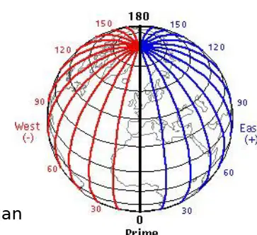
Which feature is illustrated by the lines meeting at the poles in the diagram?
Lines of latitude
Lines of longitude
Tropic of Cancer
Equator
Longitude lines run in which direction?
North to South
East to West
Diagonally
In circles
What are longitude lines also called?
Meridians
Parallels
Equators
Tropics
The distance between lines of latitude and longitude is measured in what unit?
Degrees
Kilometers
Miles
Hours
Why are latitude and longitude important for describing places on Earth?
They help identify the location of different places.
They measure the temperature of places.
They show the population of places.
They indicate the climate of places.
If a place is south of the equator, which hemisphere is it in?
Southern hemisphere
Northern hemisphere
Eastern hemisphere
Western hemisphere
Which of the following is NOT one of the five fundamental things you need to be familiar with to read a map successfully?
Compass directions
Grid references
Map's key
Longitude
Which term describes how much smaller a map is than real life?
Distance
Scale
Title
Compass
What is the easiest way to measure the distance between two places on a map according to the material?
Using a ruler directly on the map
Using a piece of paper to mark the distance and then reading off the scale
Estimating by eye
Using a calculator
Why should directions always be asked when describing a location?
To make the map look more colorful
To ensure accurate communication of where places are
To make the map easier to fold
To avoid using the scale
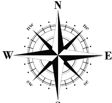
Which point on the compass is always at the top of a map?
South
East
North
West
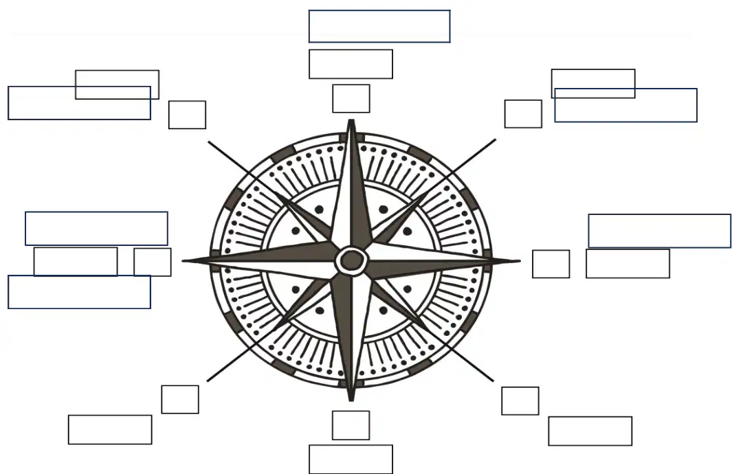
Why are maps considered very useful?
Because they give information and show where places and sites are situated
Because they are colorful and decorative
Because they are used only for navigation at sea
Because they are written in different languages
What is the purpose of a key on a map?
To show the scale of the map
To unlock the information stored in the colours and symbols on a map
To indicate the direction of north
To display the names of countries
What are grid references used for on Ordnance Survey Maps?
To pinpoint locations on the map
To measure distances between cities
To show weather patterns
To indicate population density
On an OS map, what are the horizontal lines called that cross the map from one side to the other?
Eastings
Northings
Bearings
Contours
If a red square is located at the intersection of easting 22 and northing 36, what is its four-figure grid reference?
3622
2236
2263
3326
Which of the following best describes the process of reading a grid reference on an OS map?
Numbers along the bottom come first, then numbers up the side
Numbers up the side come first, then numbers along the bottom
Only the numbers in the center are used
The largest numbers are always used first
Why might a grid of squares be drawn on a map?
To make it easier to find a particular site
To decorate the map
To show elevation
To indicate climate zones
Which of the following is the clearest way of showing relief on a map?
Using symbols
Using contour lines
Using photographs
Using written descriptions
What do numbers written along contour lines on a map indicate?
The distance between places
The height in meters
The type of vegetation
The population density
Which method uses different colours for different heights on a map?
Spot heights
Layer colouring
Contour lines
Triangulation points
Relief on a map can be shown by spot heights and triangulation points. What is another term for triangulation points?
Pillars
Valleys
Rivers
Forests
Contour lines are useful for showing relief on a map because:
They display population density.
They join places at the same height above sea level, making it easy to see elevation changes.
They indicate the direction of rivers.
They show the type of soil present.
Which statement best describes how contour lines indicate a steep slope?
Contour lines are far apart.
Contour lines are close together.
Contour lines form a circle.
Contour lines are straight.
What does a gentle slope look like on a contour map?
Contour lines are close together.
Contour lines are far apart.
Contour lines form a v-shape.
Contour lines are zigzagged.

