
Font size
S
M
L
XL
 Worksheets
Semester Exam Review
Total questions: 60
Worksheet time: 30mins
Name
Class
Date
1.
Japan is an Example of an
a)
Nation-State
b)
Empire
c)
Stateless Nation
d)
Multi-National State
e)
Multistate nation
2.
The former international border between East Germany and West Germany is best described as
a)
an open border
b)
a demilitarized zone
c)
a relict boundary
d)
an antecedent boundary
e)
a geometric boundary
3.
Which of the following describes typical characteristics of federal states?
a)
A centralized government and strong centripetal forces
b)
A fragmented land area and a single ethnic group
c)
A small land area and high population density
d)
A compact shape and a primate city
e)
A large land area and multiple ethnic groups
4.
Which of the following describes a federal form of governance?
a)
A centralized government creates a barrier to local participation in the political process.
b)
Autonomous regions act outside the authority of a central government.
c)
Federal states encourage devolutionary movements and break apart quickly.
d)
Laws are enacted in a single language to promote cultural unity.
e)
Multiple substates have local control and are unified to pursue common goals at the national level.
5.
Which of the following describes a unitary form of governance?
a)
Stronger states and transnational corporations indirectly control weaker states.
b)
A state has a strong central government with no power given to regions.
c)
A collection of independent communities shares government services.
d)
A state’s more powerful central government shares power with its regions.
e)
A sense of unity, often derived from ethnic or cultural traits, binds a country together.
6.
Which of the following best describes the role of the federal state in a country’s political organization?
a)
To act as a system of defense that protects subnational states from threats emerging outside of the country’s international borders
b)
To act as a single centralized economy for a collection of subnational states allied for a common purpose
c)
To act as an overarching government for a collection of subnational states allied for a common purpose
d)
To act as a strong centralized administration that eliminates the need for self-governing subnational or local governments
e)
To act as a virtual public-service provider that eliminates the need for self-governing subnational or local governments
7.

What do the states represented above have in common?
a)
They are all federal states.
b)
They are all formerly communist states.
c)
They are all mega states.
d)
They are all unitary states.
e)
They are all ethnic states.
8.
Which of the following is an accurate comparison of devolutionary movements in Spain and Canada?
a)
There is an economic aspect to the Quebecois independence movement, while the Catalans focus mainly on culture.
b)
Both independence movements utilize cultural distinctiveness as their only reason for seeking independence.
c)
Both independence movements focus on religious differences with the nations they currently belong to.
d)
There is an economic aspect to the Catalan independence movement, while the Quebecois focus mainly on cultural differences.
e)
Both independence movements utilize economic power as their main reason for seeking independence.
9.
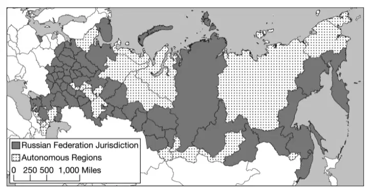
Compare the centralized power of the Soviet Union with the contemporary Russian Federation, in terms of the control of territory. Which of the following statements does the information in the map best support?
a)
Russia is a global power with concentrated power in East Asia.
b)
Russia is a multistate nation made up of numerous sovereign independent entities.
c)
Russia’s autonomous regions illustrate a strategy to counter the difficulty in governing such a large area from a single centralized location.
d)
Russia is an ethnically diverse region with many subnational units.
e)
Russia used to control fifteen additional republics that regained their independence in 1990.
10.
Which of the following events could be a threat to a state’s sovereignty at the national scale, while holding a region together at the global scale?
a)
A natural disaster such as an earthquake or tsunami occurring within the country
b)
A member of the state’s minority political party being elected to lead the country
c)
Admittance into a supranational organization such as the European Union
d)
Decommitment to environmental resolutions established by the United Nations
e)
A shift from a federal system to a unitary system of governance within the state
11.
Which of the following correctly compares the impact of centripetal forces at the local scale with the impact of centripetal forces at the national scale?
a)
Centripetal forces may cause uneven development at the local scale but not at the national scale.
b)
Centripetal forces at both the local scale and the national scale may lead to increased cultural cohesion.
c)
Centripetal forces may lead to stateless nations at the national scale but not the local scale.
d)
Centripetal forces may result in nationalism at the local scale but not at the national scale.
e)
Centripetal forces at both the local scale and the national scale may lead to failed states.
12.
Which of the following compares the impact of increased global communications technology to the impact of state-controlled media?
a)
Both global communication technology and state-controlled media act as centripetal forces that present a common message, which is utilized by the government to bind citizens together.
b)
Neither global communications technology nor state-controlled media have any impact on the viability of a state when it comes to centripetal or centrifugal forces.
c)
Global communications technology is utilized as a centripetal force to present a common message, whereas state-controlled media may bring in new ideas that act as centrifugal forces.
d)
Both global communications technology and state-controlled media act as centrifugal forces because they give citizens access to concepts or ideas that may inspire dissent.
e)
Global communications technology may bring in new ideas that act as centrifugal forces, whereas state-controlled media is utilized as a centripetal force to present a common message.
13.
Which of the following describes an example of a consequent boundary?
a)
The Berlin Wall between East and West Germany no longer exists, but the location is still evident.
b)
European powers divided Africa at the Berlin Conference and drew boundaries across the continent.
c)
The United States–Canadian boundary was set at the 49th parallel by a treaty before the area was settled.
d)
Canada created the province of Nunavut to provide greater autonomy for the First Nations.
e)
The Andes Mountains are used as a political boundary to divide Chile and Argentina.
14.
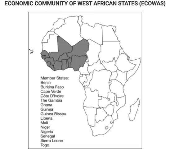
Which of the following is the correct organizational scale for the Economic Community of West African States (ECOWAS)?
a)
Global
b)
Supranational
c)
National
d)
State
e)
Local
15.

In the United States House of Representatives there are a fixed number of 435 seats divided among the states based upon each state’s relative population size. Changes in the number of representatives, as shown on the map, affect politics at which of the following scales?
a)
City
b)
County
c)
State
d)
Regional
e)
National
16.
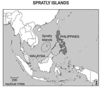
The Philippines and Malaysia lay claim to resources under and around the Spratly Islands. Which of the following best explains how the United Nations Convention on the Law of the Sea (UNCLOS) influences claims to the islands by both countries?
a)
The claims to the Spratly Islands by both the Philippines and Malaysia overlap due to exclusive economic zones up to 200 nautical miles from their coasts.
b)
The Philippines and Malaysia both claim the islands lie within their territorial seas up to 12 nautical miles from their coasts.
c)
The claims to the islands by the Philippines and Malaysia overlap due to the median line principle.
d)
The Philippines and Malaysia both claim ownership to the resources based on a historic possession of the islands.
e)
The Philippines and Malaysia both claim the islands lie within their contiguous zones between 12 and 24 nautical miles from their coasts.
17.
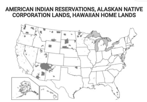
Which of the following best explains the governance of the shaded areas shown on the map?
a)
These areas are established as nation-states for indigenous peoples at the local scale.
b)
These areas show territory occupied by indigenous peoples as stateless nations at a local scale.
c)
These areas show territory controlled by indigenous peoples as a single multistate nation.
d)
These areas show where indigenous peoples have a limited amount of self-government at a national scale.
e)
These areas are lands of indigenous peoples that are sovereign independent states at an international scale.
18.

Using the data in the table and the description, which of the following identifies the scales of analysis that are reflected in this redistricting?
a)
Member state representation in a supranational legislature
b)
Local representation in the state legislature
c)
State representation in the regional legislature
d)
Local representation in the national legislature
e)
Local representation in the regional legislature
19.
Jammu and Kashmir is a region claimed by India, China, and Pakistan. Each side lays claim to the area because of its history and people. This is an example of which type of boundary
a)
Allocational/ resource
b)
Definitional/Positional
c)
Locational/Territorial
d)
Operational/Functional
e)
Military/Treaty
20.
The Berlin Conference established the borders of North African countries including Egypt, Libya, and Sudan. The landscape of these countries influenced the types of boundaries imposed by the European colonial powers. Which of the following boundary types best explains the influence of landscape on the political borders of the North African region?
a)
Antecedent, based on tribal cultural boundaries that existed before European colonization
b)
Subsequent, with smaller buffer states placed between larger states to prevent political conflicts
c)
Consequent, accounting for local differences in language and religion during European colonization
d)
Natural, with irregular lines, accounting for regional physical features such as mountains or water bodies
e)
Geometric, with straight lines, disregarding physical features or tribal cultural differences of the areas
21.
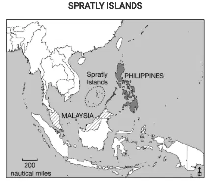
The Philippines and Malaysia lay claim to resources under and around the Spratly Islands. Which of the following best explains how the United Nations Convention on the Law of the Sea (UNCLOS) influences claims to the islands by both countries?
a)
The claims to the Spratly Islands by both the Philippines and Malaysia overlap due to exclusive economic zones up to 200 nautical miles from their coasts.
b)
The Philippines and Malaysia both claim the islands lie within their territorial seas up to 12 nautical miles from their coasts.
c)
The claims to the islands by the Philippines and Malaysia overlap due to the median line principle.
d)
The Philippines and Malaysia both claim ownership to the resources based on a historic possession of the islands.
e)
The Philippines and Malaysia both claim the islands lie within their contiguous zones between 12 and 24 nautical miles from their coasts.
22.
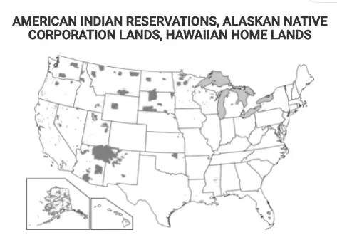
Which of the following best explains the governance of the shaded areas shown on the map?
a)
These areas are established as nation-states for indigenous peoples at the local scale.
b)
These areas show territory occupied by indigenous peoples as stateless nations at a local scale.
c)
These areas show territory controlled by indigenous peoples as a single multistate nation.
d)
These areas show where indigenous peoples have a limited amount of self-government at a national scale.
e)
These areas are lands of indigenous peoples that are sovereign independent states at an international scale.
23.
Country A and B are divided by a large river. Over time the river shifted causing some residents of country A to now be located in country B. This could cause a
a)
Definitional boundary dispute
b)
Locational boundary Dispute
c)
Operational Boundary dispute
d)
Allocational boundary dispute
e)
24.
Which of the following is an example of a superimposed boundary?
a)
The geometric boundary between the United States and Canada
b)
The border of the European Union
c)
The Pyrenees Mountains between France and Spain
d)
The geometric boundary between Iraq and Saudi Arabia
e)
The Great Wall of China
25.
The 49th parallel, the line of latitude used to delimit the boundary that separates the western United States from Canada, is an example of what type of boundary?
a)
Subsequent boundary
b)
Anticedent
c)
relic boundary
d)
consequent boundary
e)
Satellite State
26.
Which of the following describes the primary type of boundary imposed in Africa as a result of the Berlin Conference
a)
Antecedent
b)
Relic
c)
Superimposed
d)
Subsequent
e)
Consequent
27.
Some territories within the Russian Federation are characterized by concentrated populations of ethnic groups and these areas function as autonomous republics. Which of the following best explains the political relationship between the autonomous republics and the central government of Russia?
a)
The central government of Russia exerts complete control over the autonomous republics to counteract devolutionary pressures.
b)
The autonomous republics are able to function independently from the central government because of an abundance of natural resources.
c)
Russia is a multistate nation characterized by contested regional boundaries.
d)
The autonomous republics provide ethnic groups with some political control over their homelands while preserving Russia’s territorial integrity.
e)
Russia is a unitary state characterized by many ethnic groups united within a single country.
28.
Which of the following best explains the effect of French language and culture on the federal state of Canada’s political power?
a)
French language and culture act as a centripetal force throughout Canada as the majority of Canadians have English as a first language and the government uses both languages in official communications.
b)
As an expression of political power, the Canadian federal government restricts French language and culture from media and government proceedings.
c)
French language and culture act as centripetal forces and unify all of Canada’s people and government into a single nation.
d)
French language and culture act as a centrifugal force in Canada because independence movements in Quebec have attempted to secede the province from Canada.
e)
Because French Canadians are spread across the country’s provinces, the Canadian government implemented federal laws to create a common culture and language for all Canadians.
29.
Which of the following explains why Korea and Vietnam were viewed as shatterbelts during the Cold War?
a)
Korea and Vietnam were politically controlled by regional powers.
b)
Korea and Vietnam kept two political adversaries geographically separated.
c)
Korea and Vietnam fragmented into new states due to internal tensions.
d)
Korea and Vietnam tried to control land and sea areas around their states.
e)
Korea and Vietnam experienced conflict due to a dispute between global powers.
30.
Which of the following explains why the India-Pakistan region is considered a shaterbelt?
a)
Both countries were once colonies of different European Countries
b)
The Area is a buffer zone between Muslims and Hindus
c)
India and Pakistan experience conflict due to disputes between religion
d)
India and Pakistan fragmented into new states due to internal tensions
e)
India and Pakistan both claim resources found in the region
31.
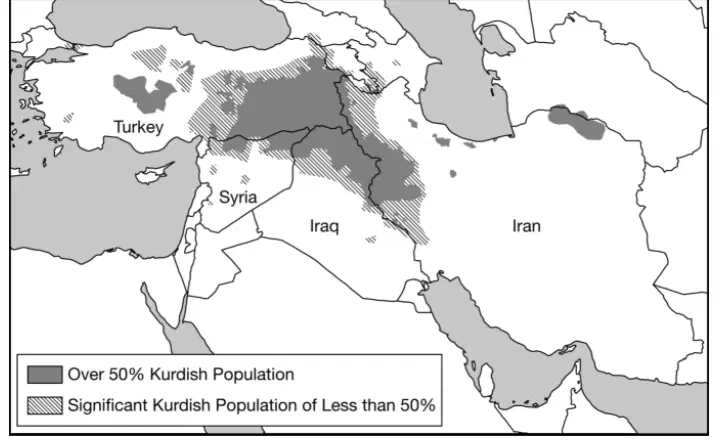
Based on the information in the map, what is the most likely outcome of the possible establishment of an independent Kurdistan for the Kurdish people?
a)
The state of Turkey, seeking to connect areas with a substantial Kurdish population into an independent state, might take action against neighboring states.
b)
The Kurdish people, seeking a state of their own with a majority Kurdish population, might secede from or rebel against the states labeled on the map.
c)
The Kurdish people would have to migrate into a single country to gain a population majority and would struggle for control of the government.
d)
In areas with a Kurdish majority population, Kurdish people are politically active among Turks, Iranians, Iraqis, and Syrians and would be able to win an election on a national vote to secede.
e)
The countries shown on the map will cooperate and work together to address the political situation and needs of people in areas with a substantial Kurdish population
32.
France expanded from a small area around the Present capital city of Paris to its current much larger territory. The place where France Expanded from is an example of a
a)
nome
b)
Core area
c)
Escarpment
d)
Sovereign area
e)
Self determination
33.
A nation's ability to determine its own statehood and form its own allegiance is and government: the Freedom of culturally distinct groups to govern themselves in their own territories and form their own states is called?
a)
Self-determination
b)
Self Respect
c)
Stateless nation
d)
escarpments
e)
Core area
34.

Which of the following best explains why the region of Catalonia in Spain could be a viable country?
a)
Catalonia is linguistically distinct compared to other regions in Spain.
b)
Catalonia is well developed economically compared to other regions in Spain.
c)
Catalonia has a large population compared to other regions in Spain.
d)
Catalonia's population is ethnically distinct compared to other regions in Spain.
e)
Catalonia has a major city, Barcelona, which has a notoriety comparable to that of the Spanish capital, Madrid.
35.

Which of the Following Terms correctly identifies the Political entity shaded on the map of North America?
a)
Nation-State
b)
Multination Stae
c)
Empire
d)
Nation
e)
Kingdom
36.
The Process in which a state breaks down do to conflicts among its ethnicities is known as
a)
Devolution
b)
Self-determination
c)
Sovereignty
d)
Balkanization
e)
Colonialism
37.
Which of the following describes typical characteristics of federal states?
a)
A centralized government and strong centripetal forces
b)
A fragmented land area and a single ethnic group
c)
A small land area and high population density
d)
A compact shape and a primate city
e)
A large land area and multiple ethnic groups
38.
Which of the following describes a federal form of governance?
a)
A centralized government creates a barrier to local participation in the political process.
b)
Autonomous regions act outside the authority of a central government.
c)
Federal states encourage devolutionary movements and break apart quickly.
d)
Laws are enacted in a single language to promote cultural unity.
e)
Multiple substates have local control and are unified to pursue common goals at the national level.
39.
Which of the following describes a unitary form of governance?
a)
Stronger states and transnational corporations indirectly control weaker states.
b)
A state has a strong central government with no power given to regions.
c)
A collection of independent communities shares government services.
d)
A state’s more powerful central government shares power with its regions.
e)
A sense of unity, often derived from ethnic or cultural traits, binds a country together.
40.
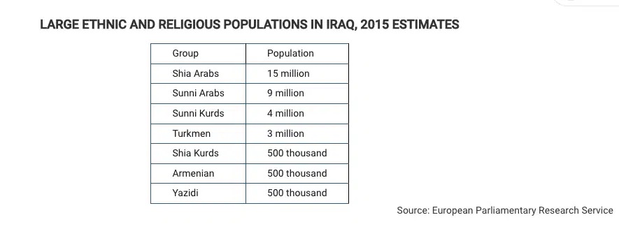
Based on the data in the table, which of the following is a possible impact of ethnic and religious diversity in Iraq?
a)
Ethnicity and religion act as centripetal forces in the country by creating a common Iraqi identity among the population.
b)
Ethnicity and religion facilitate democratization in the country by motivating participation in elections.
c)
Ethnicity and religion promote economic development in the country by generating national pride in the country’s accomplishments.
d)
Ethnicity and religion lead to devolutionary pressures in the country by politically dividing regions.
e)
Ethnicity and religion increase cultural cohesion in the country by promoting shared political ideology.
41.

Based on the map, which of the following best explains the implications of physical geography as the Kurds continue to struggle for an independent state in their ethnic homeland?
a)
Israel, Turkey, and Russia have voiced their support for an independent Kurdistan in areas with a majority Kurdish population, showing potential validation for Kurdistan.
b)
In September 2017 a public referendum was carried out that demonstrated that a majority of Kurds overwhelmingly support independence.
c)
Most areas with a Kurdish majority population are landlocked and therefore dependent on good relationships with their neighbors in order to access trade and prosper economically.
d)
Even in areas with a Kurdish minority population, Kurdish people have their own unique culture and identity separately from the states in which their nation is located.
e)
Unstable oil prices have created economic problems both in parts of the region with a Kurdish majority population and in parts with a Kurdish minority, leaving the Kurdistan Regional Government weakened and struggling to pay off debt.
42.
The movement of Power from the central government to regional governments within the state
a)
Sovereign area
b)
Self Determination
c)
Devolution
d)
escarpments
e)
core area
43.
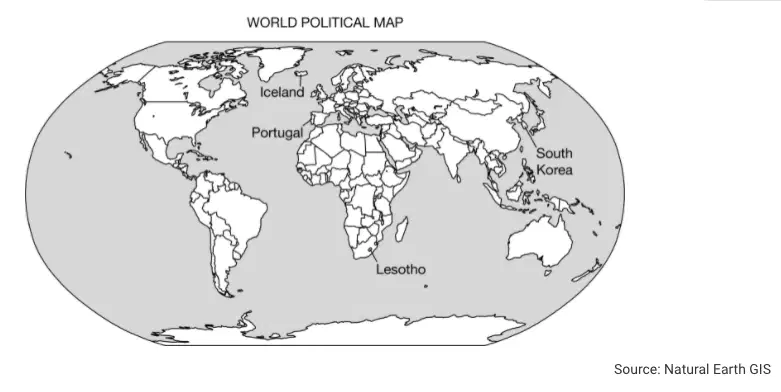
Owing to their localized geography or their locations on islands or peninsulas, many small political entities such as those labeled on the political map of the world can be identified as
a)
federal states
b)
autonomous republics
c)
multistate nations
d)
nation-states
e)
colonial territories
44.
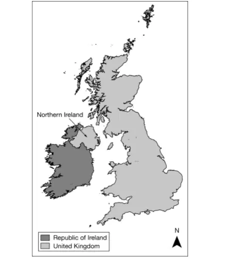
Based on the map, which of the following can be identified as a true statement about Northern Ireland?
a)
It is united with the rest of the island to form a sovereign nation-state.
b)
It forms its own sovereign nation-state predominately made up of the Irish ethnic group.
c)
It is a frontier that is not formally part of a state, but the United Kingdom claims the area.
d)
It is physically separate from the rest of the United Kingdom, a multinational state.
e)
It is a stateless nation, as the entire island of Ireland is under the control of the United Kingdom.
45.
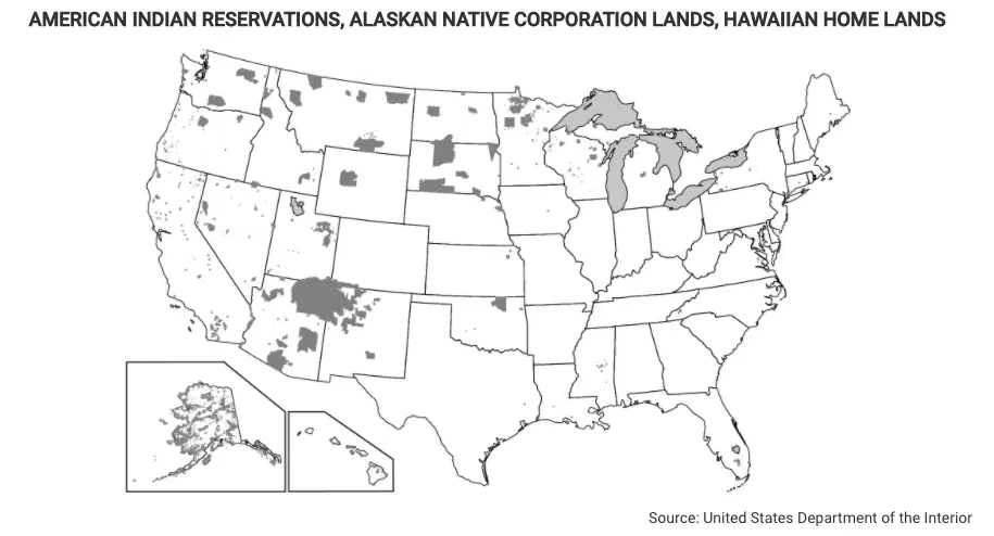
Which of the following terms identifies the type of regions shown in the dark gray-shaded areas on the map?
a)
Functional regions
b)
Urban regions
c)
Physical regions
d)
Vernacular regions
e)
Semiautonomous regions
46.
Which statement best describes the most common reason groups wish to preserve their traditional languages?
(Unit 3)
a)
Language is central to cultural identity, so preserving a language helps preserve a culture.
b)
Language is used in religious services, so preserving a language is primarily a religious obligation.
c)
Language is used for trade, so preserving language is one way to keep a group economically prosperous.
d)
Language change is a politically disruptive force, so preserving a language is one way to keep stability.
e)
Language preservation passes on a group's history, so preserving a language is the only way to record history accurately.
47.
The Arabic language spread from its hearth and became one of the major global languages mainly through
(Unit 3)
a)
increased use of communication technology in Arab nations
b)
spread of Middle Eastern multinational oil corporations
c)
worldwide colonization beginning around 600 C.E.
d)
conquest and its use as a standard religious language
e)
resisting colonization by European nations and the United States
48.
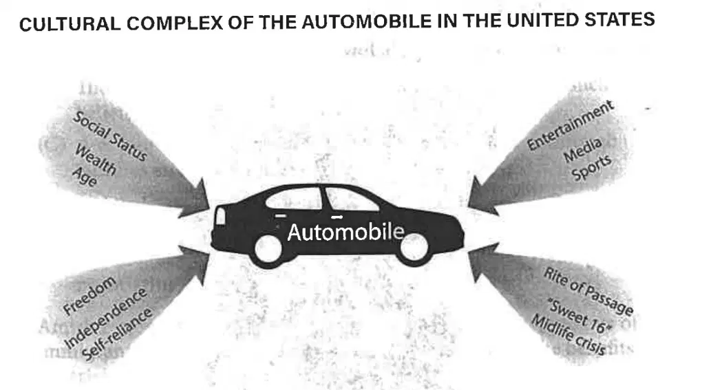
According to the cultural complex described in the diagram, auto ownership provides transportation but also
(Unit 3)
a)
represents a set of American cultural traits, such as self-reliance and independence
b)
provides greater likelihood that its owner will attain American values such as wealth
c)
represents one American cultural trait, depending on the values of the auto's owner
d)
comes about as a result of possession of a particular American trait, such as wealth
e)
helps identify the owner's cultural landscape, region, realm, and level of freedom
49.
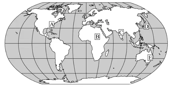
On the map above, which one of the following boxes is in an area where the population density is high and the level of economic development is low?
(Unit 2)
a)
a
b)
B
c)
C
d)
D
e)
E
50.
Which of the following explains the major effect of migration flow to Southwest Asia from other regions in Asia?
(Unit 2)
a)
Students migrate to attend school in the region, increasing the technology labor force.
b)
Women and children migrate to reunify with male relatives living in the region, forming permanent urban settlements.
c)
People with chronic illnesses travel as medical tourists to obtain medical care, growing the health care industry.
d)
Guest workers migrate to the region for jobs in construction and the oil fields, increasing the volume of exports from the region
e)
Older adults migrate to areas with warmer climates after retiring from their jobs, growing the service industry.
51.
Physiological population density differs from crude population density in that physiological density
(Unit 2)
a)
examines only the population of cities, while crude density includes the population of cities and rural areas
b)
is a measure of how density is perceived, while crude density is a measure of specific density
c)
explains density in terms of people per arable square land unit, while crude density explains density in terms of people per total square land unit
d)
explains the density of a single housing unit while crude density explains the density of a group of houses
e)
is the number of people per housing unit, while crude density is the number of people per square mile
52.
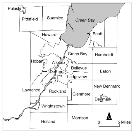
Which of the following scales is represented in the map shown?
(Unit 1)
a)
Local, showing the towns and township areas in a county
b)
Regional, showing the states or provinces in one part of a country
c)
State or province, showing the counties or parishes
d)
Neighborhood, showing the block along street boundaries
e)
Block, showing the property lines and names of owners
53.
In the early part of the Industrial Revolution in Europe, Thomas Malthus developed a theory that population increases exponentially, while food production can increase only arithmetically. Which of the following statements best explains how the Industrial Revolution reduced the threats forecast by Malthus?
(Unit 2)
a)
The resulting rural-to-urban migration for jobs in factories led to a decline in birth rates and lowered population growth rates below what Malthus predicted.
b)
Industrialization led to the manufacture of weaponry used in warfare, resulting in higher mortality during the conflicts of the nineteenth and twentieth centuries that dramatically reduced populations.
c)
The migration of people from rural areas to factory cities allowed farmers to expand their farm size and increase food production above Malthus’ predictions.
d)
Industrialization enabled and promoted European imperialism, and Europeans migrated to overseas colonies, reducing the European population.
e)
Mechanization expanded to agriculture, increasing the need for agricultural labor to run the equipment, leading rural families to have more children and increasing population growth.
54.

The low birth and death rates for a country in stage 4 of the demographic transition model are best explained by
(Unit 2)
a)
the rural population and agricultural livelihood of a less developed country.
b)
the level of education and traditional roles for women in a less developed country
c)
the resource-based economy and life expectancy of a less developed country
d)
the level of urbanization and technological advancement of a more developed country
e)
the environmental pollution and manufacturing infrastructure of a more developed country
55.

Which of the following describes the spatial pattern shown in the map of total fertility rates?
Total Fertility Rate By Country
(Unit 2)
a)
The highest total fertility rates are shown in Latin America, North Africa, South Asia, and Central Asia.
b)
The lowest total fertility rates are shown in Latin America, North Africa, South Asia, and Central Asia.
c)
The lowest total fertility rates are shown in sub-Saharan Africa and parts of the Middle East.
d)
The lowest total fertility rates are shown in Europe, Russia, East Asia, Australia, and Canada.
e)
The highest total fertility rates are shown in Europe, Russia, East Asia, Australia, and Canada.
56.
Which of the following describes a concern for a country with an aging population?
(Unit 2)
a)
As a country’s population ages, the life expectancy for the younger population of the country decreases and healthcare costs decline.
b)
As a country’s population ages, the infant mortality rate decreases and there is an increased need for daycare centers.
c)
As the proportion of older people in the country increases, fewer young workers are available to contribute tax revenues to support programs that provide services to the older population.
d)
As the proportion of older people in the country increases, the sex ratio becomes disproportionally skewed toward males.
e)
As the proportion of older people increases, the total population decreases because older people do not have children.
57.
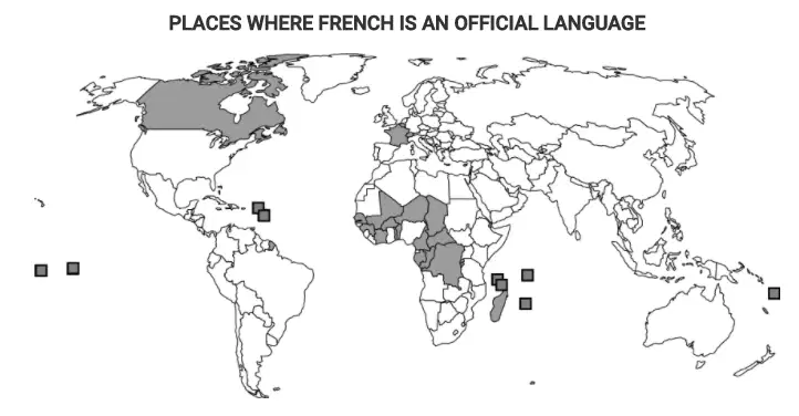
How does the map illustrate global diffusion of the French language from its cultural hearth in Paris?
(Unit 3)
a)
The map shows how French-language movies, music, and literature dominate global entertainment media.
b)
The map shows how France was an ancient-culture hearth from which the French language spread through expansion diffusion.
c)
The map shows how in many areas of the former French empire the language persists despite the independence of former colonies.
d)
The map shows how French civil servants established schools in many parts of the French colonial empire.
e)
The map shows how people’s love of French food has facilitated the spread of the French language to many parts of the world.
58.
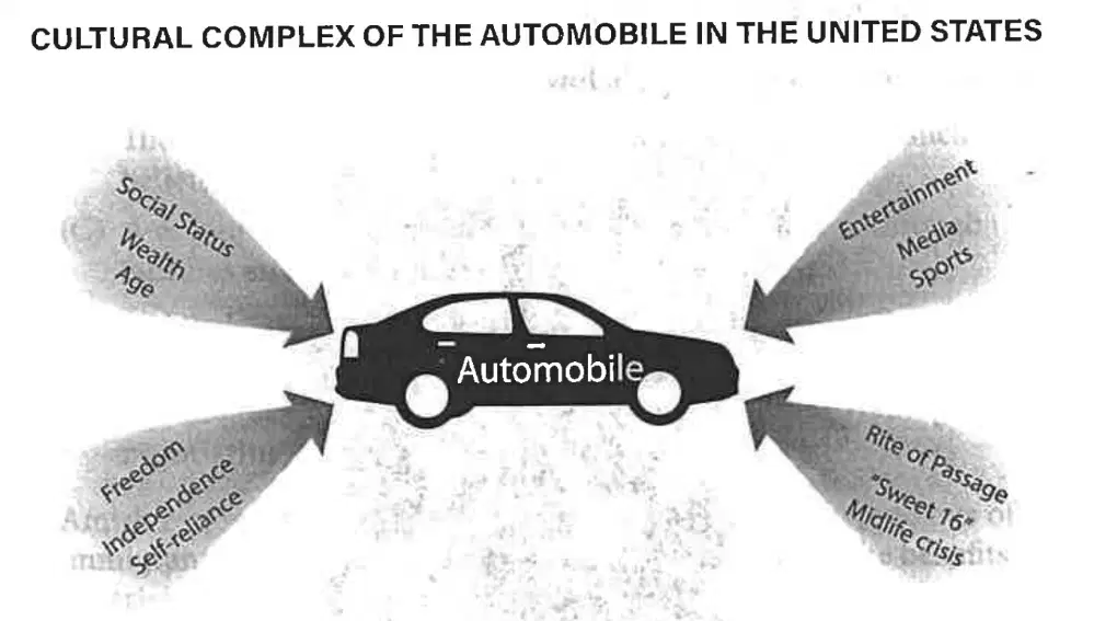
According to the cultural complex described in the diagram, auto ownership provides transportation but also
(Unit 3)
a)
represents a set of American cultural traits, such as self-reliance and independence
b)
provides greater likelihood that its owner will attain American values such as wealth
c)
represents one American cultural trait, depending on the values of the auto's owner
d)
comes about as a result of possession of a particular American trait, such as wealth
e)
helps identify the owner's cultural landscape, region, realm, and level of freedom
59.
There has been an increase in asylum seekers from Syria to the European Union in recent years. Which of the following best describes the reason for this migration?
(Unit 2)
a)
A large rural-to-urban population shift within Syria
b)
A continuing rise in employment for asylum seekers in the European Union
c)
A continuing issue of conflict and political unrest within Syria
d)
The tightening of asylum policies by the European Union
e)
The tightening of guest-worker policies by the European Union
60.
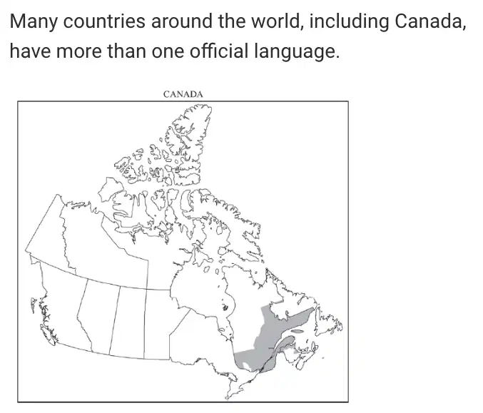
A. Identify the primary language spoken by most inhabitants in the shaded area on the map. (10 points)
B. Explain how bilingualism can have a positive impact on a country. (10 points)
C. Explain how bilingualism can have a negative impact on a country.(10 points)
D. Discuss TWO reasons, other than language, why Canada does not fit the nation-state concept.(10 points)
4 lines
Reset

