


8th Grade Countries in Asia Quizzes
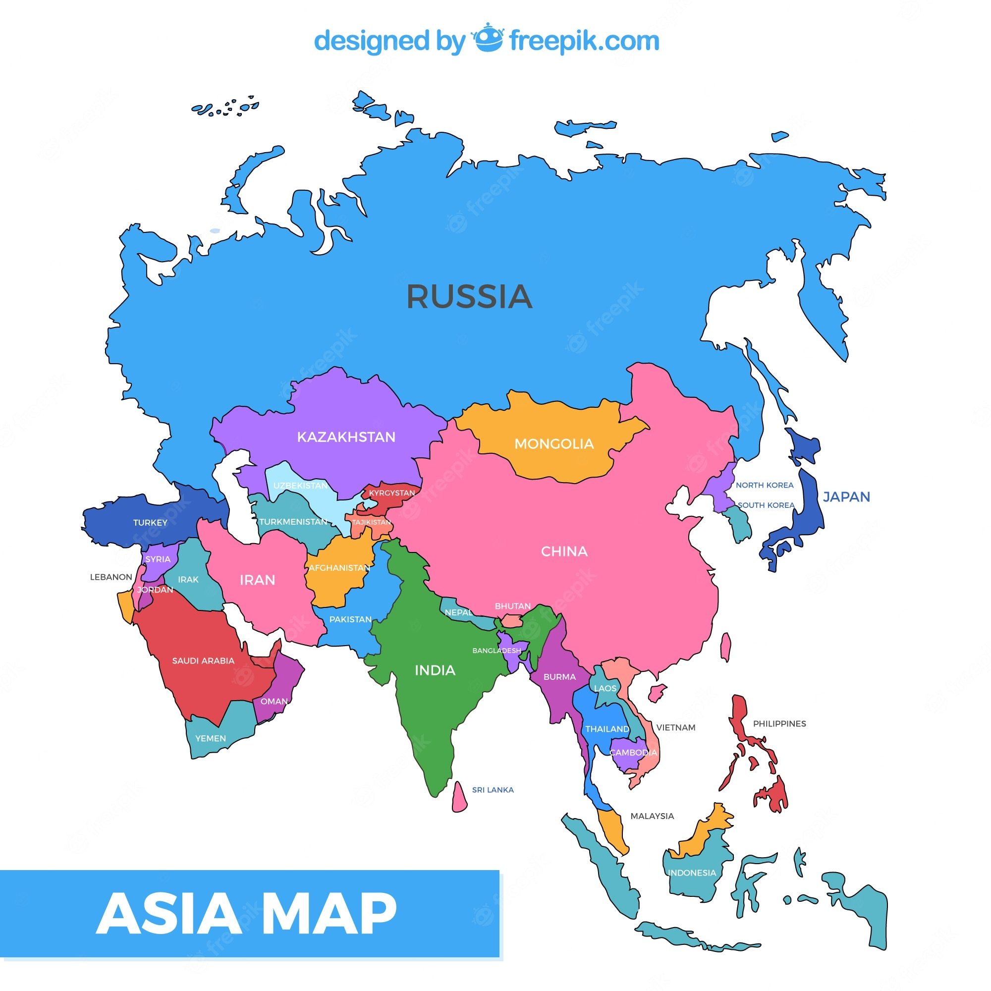
Test your knowledge of Countries in Asia with this comprehensive Grade 8 quiz designed to assess understanding through practice questions and instant feedback. Challenge yourself with self-paced assessment covering key Asian nations, their locations, capitals, and geographical features.

15 questions
Countries in Asia

Quiz
•
4th Grade
15 questions
Countries in Asia
Quiz
•
4th Grade

25 questions
Countries in Asia
Quiz
•
4th Grade

10 questions
Quiz Module 3 Countries in Asia
Quiz
•
7th - 12th Grade

26 questions
Asian Countries
Quiz
•
6th - 8th Grade

20 questions
East Asia Review
Quiz
•
6th - 8th Grade
12 questions
Intro. to Asia: graded quizziz
Quiz
•
7th - 9th Grade
16 questions
PR - 2nd Asia Geography Quiz Check In
Quiz
•
6th Grade
16 questions
Southwest Asia
Quiz
•
8th - 12th Grade
12 questions
North Africa & SW Asia Countries
Quiz
•
8th Grade
17 questions
Geography of South Asia Quiz Review
Quiz
•
8th Grade
9 questions
Bamboo People: Burma (CIA Fact Book) Geography
Quiz
•
8th Grade
Explore 8th Grade Countries in Asia Quizzes
Countries in Asia geography quizzes for Grade 8 students provide comprehensive assessment tools that develop essential geographic knowledge and spatial reasoning skills. These practice questions challenge students to identify Asian nations, understand their locations, recognize capital cities, and analyze the diverse political and physical characteristics across the continent. Through targeted feedback and varied question formats, students strengthen their understanding of Asia's complex regional divisions, from East Asia's economic powerhouses to Southeast Asia's archipelagos and Central Asia's landlocked nations. The assessment materials systematically build familiarity with country names, boundaries, and geographic relationships while reinforcing critical thinking about cultural and economic patterns across this vast and diverse continent. Wayground's extensive collection draws from millions of teacher-created geography resources, enabling educators to locate precisely the right assessment materials for their Grade 8 curriculum needs. The platform's robust search and filtering capabilities allow teachers to identify quizzes aligned with specific educational standards while customizing difficulty levels and question types to match diverse learning needs. Digital delivery formats support immediate feedback and adaptive learning paths, while differentiation tools help teachers address varying skill levels within their classrooms. These flexible assessment options enhance lesson planning by providing reliable tools for initial knowledge checks, ongoing skill reinforcement, targeted remediation for struggling learners, and enrichment opportunities for advanced students ready to explore more complex geographic relationships across Asian countries.
FAQs
How do I teach countries in Asia to my students?
Start by introducing Asia's major regions — East Asia, Southeast Asia, South Asia, Central Asia, and the Middle East — before drilling into individual countries. Use political maps to help students visualize borders and capitals, then layer in physical geography and cultural context. Connecting each country to real-world events or landmarks gives students an anchor point that makes the content stick.
What exercises help students practice identifying countries in Asia?
Map labeling exercises are among the most effective tools for building country recognition, requiring students to place country names and capitals without a reference guide. Matching activities that pair countries with their capitals, flags, or key geographic features reinforce recall through repeated low-stakes practice. Combining these with blank-map fill-ins builds both spatial memory and confidence over time.
What mistakes do students commonly make when learning countries in Asia?
Students frequently confuse neighboring countries with similar-sounding names, such as Kazakhstan, Kyrgyzstan, Tajikistan, Turkmenistan, and Uzbekistan. They also tend to misplace countries in the Middle East, often placing them in Africa or Europe due to limited prior exposure. Another common error is conflating a country's capital with its largest or most well-known city — for example, assuming Beijing is China's largest city rather than its capital, or misidentifying Islamabad as Karachi.
How do I use Countries in Asia quizzes from Wayground in my classroom?
Wayground's Countries in Asia quizzes are available as printable PDFs for traditional classroom use and in digital formats for technology-integrated environments, giving you flexibility depending on your setup. You can assign them as independent practice, homework, or formative assessment, and each quiz includes a complete answer key so grading is straightforward. For digital use, you can host the quiz as a quiz directly on Wayground, allowing for real-time student responses and instant feedback.
How do I differentiate Countries in Asia instruction for students at different skill levels?
For students who need additional support, start with regional groupings and word banks on map activities before moving to fully independent identification tasks. More advanced learners can move beyond country recognition into comparative analysis — examining economic systems, demographic patterns, or regional trade relationships. On Wayground, you can apply individual accommodations such as read aloud support or reduced answer choices to specific students, ensuring every learner accesses the material at the right level of challenge.
How do I align Countries in Asia lessons with geography standards?
National geography standards emphasize spatial thinking, place knowledge, and human-environment interaction — all of which map directly onto countries in Asia content. Lessons should address political boundaries and capitals alongside physical features like mountain ranges, river systems, and climate zones to meet the breadth those standards require. Quizzes that integrate both map skills and analytical questions about regional relationships help students meet higher-order geographic thinking benchmarks.

Accessibility
Features
Wayground Super
School & District
Wayground for Business
Create a quiz
Create a presentation
Wayground AI
Subjects
Mathematics
Social Studies
Science
Physics
Chemistry
Biology
About
Our Story
Wayground Blog
Media Kit
Careers
Support
F.A.Q.
Help & Support
Privacy Policy
Terms of Service
Teacher Resources
2026 Wayground


Get our app

