
Maps and Computers
Presentation
•
Science
•
8th Grade
•
Practice Problem
•
Medium
Standards-aligned

Randi Kelleher
Used 13+ times
FREE Resource
10 Slides • 10 Questions
1
Maps and Computers
8th Grade Science

2
3
4
GPS
A method of finding latitude, longitude, and elevation of points on Earth's surface by using a network of satellites.

5
Satellite Images
Pictures of the Earth's surface made up of thousands of tiny dots called pixels.

6
Topographic Map
Map showing the surface features of an area using symbols to portray the land as if you were looking from above.

7
8
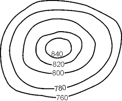
Contour Lines
Represent elevation, relief, and slope while also connecting points of equal elevation.

9
Contour Lines
Contour intervals - change in elevation from one contour line to another
Index contours - darker line than the others and are labeled with the elevation above sea level in round units.

10
11
Multiple Choice

Match the topographic map to its profile picture.
12
Multiple Choice

Match the topographic map to its profile.
13
Multiple Choice
14
Multiple Choice
15
Multiple Choice
16
Multiple Choice
17
Multiple Choice
18
Multiple Choice
19
Multiple Choice
20
Multiple Choice
Maps and Computers
8th Grade Science
Show answer
Auto Play
Slide 1 / 20
SLIDE
