Search Header Logo
Marine Science Ch 5

Marine Science Ch 5

Assessment

Presentation

Science

9th Grade

Practice Problem

Medium

NGSS
MS-ESS2-6, MS-ESS2-5, MS-PS1-4

+18

Standards-aligned

Created by

Nikkole Wowaka

Used 11+ times

FREE Resource

71 Slides • 62 Questions

1

Marine Science Ch 5

Slide image

2

Slide image

3

Multiple Choice

Ocean circulation profoundly effects terrestrial habitats

1

true

2

false

4

Slide image

5

Multiple Choice

the state of the atmosphere at a place and time as regards heat, dryness, sunshine, wind, rain, etc.

1

weather

2

climate

6

Slide image

7

Multiple Choice

Near Earths surface the gas molecules are _________ compared to the outer parts of the atmosphere

1

spread apart

2

closer together

8

Slide image

The layers above the Earth include the troposphere (to ~20 km), stratosphere (to ~50 km), mesosphere (to ~85 km), thermosphere (to ~650 km), and exosphere (to ~10,000 km). They are separated by the tropopause, stratopause, mesopause, and thermopause, respectively. 

9

Multiple Choice

The first layer of the atmosphere closest to Earths Surface

1

Mesosphere

2

Stratosphere

3

Troposphere

4

Thermosphere

5

Exosphere

10

Slide image

11

Multiple Choice

The Sun’s light energy is evenly distributed across Earth’s surface

1

true

2

false

12

Slide image

13

Multiple Choice

the angle of the Sun’s rays changes with Earth’s

1

latitude

2

longitude

14

Slide image

At the equator, the Sun’s rays strike head-on: perpendicular to the Earth’s surface. In the temperate regions, the Sun’s rays strike the Earth at an angle to the Sun. At the North and South Pole, the Sun’s rays strike the Earth parallel to its surface. These differences are due to the curvature of the Earth.

15

Slide image

16

Multiple Choice

the suns rays are more concentrated at the

1

poles

2

equator

17

Slide image

18

Fill in the Blank

The ______ house affect

19

Slide image

20

Multiple Select

The most important greenhouse gases are

1

water vapor

2

carbon dioxide

3

methane

4

oxygen

5

nitrous oxide

21

Slide image

Methane, nitrous oxide, carbon dioxide, and water vapor in the atmosphere tend to block the Sun’s heat from being reflected back to space. This is great in small amounts, because it makes the Earth hospitable, but as the greenhouse gases accumulate in the atmosphere, they continue to warm the surface.

22

Slide image


23

Multiple Choice

Isotopes are two or more forms of the same element that contain equal numbers of protons but different numbers of

1

neutrons

2

electrons

3

ions

4

protons

24

Slide image

This graph shows years before present (from 800,000 to 0) on the x-axis and CO2 concentration in ppm (from 160 to 420) on the y-axis. CO2 concentrations varied from around 180 to 300 ppm until very recently; it was at 403 ppm in 2016.

25

Multiple Choice

The ________ heating of Earth’s surface, as well as its rotational pattern, are responsible for the wind and weather patterns experienced on land and at sea.

1

equal

2

unequal

26

Slide image

27

Multiple Choice

The magnitude of the Coriolis effect increases as you go...

1

toward the poles

2

away from the poles

28

Slide image

29

Multiple Choice

In the northern hemisphere things deflect to the

1

left

2

right

30

Slide image

Because of the Earth’s rotation, if a pilot does not account for the Coriolis effect in the northern hemisphere, the plane would be deflected to the right. For example, if a pilot leaves the North Pole and heads for South Carolina without taking the Coriolis into effect, they will end up in San Diego.

31

Multiple Choice

As air gets warmer it gets

1

more dense

2

less dense

32

Slide image

33

Multiple Choice

The rising and falling circular movement is called

1

convection

2

correction

3

synthesion

4

hydrolesion

34

Slide image

The rising air near the equator allows for cooler, denser air farther north to move in and take its place. This creates the trade winds. They blow on an angle because of the Earth’s rotation. 

35

Multiple Choice

winds move straight from the equator to the poles

1

true

2

false

36

Slide image

37

Multiple Select

Three distinct convective cells form over each hemisphere

1

trade winds

2

northerlies

3

westerlies

4

polar easterlies

5

southerlies

38

Slide image

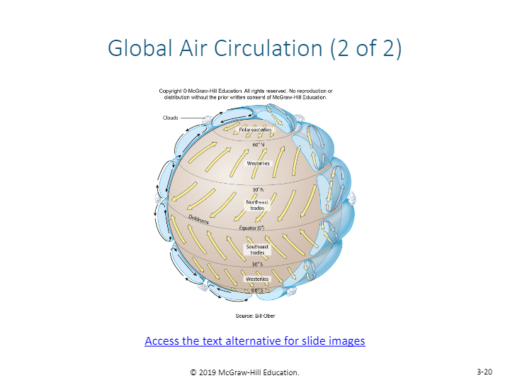
The major wind patterns on Earth including the trade winds, which lie between ~30 degrees north and south latitude, and the westerlies found at about 30 – 60 degrees in the northern and southern hemispheres. Above sixty degrees are the most variable winds, the polar easterlies.

39

Multiple Choice

trade winds are near the

1

poles

2

equator

40

Slide image

41

Multiple Choice

the wind and the Coriolis effect create what type of pattern with the water

1

straight fast moving currents

2

a spiral effect in the water

3

movement of water straight down to the bottom of the ocean

42

Slide image

43

Multiple Choice

the effects of wind ________ with water depth

1

increase

2

decrease

44

Slide image

Because of the Coriolis effect, the surface layer of the water flows at a 45 degree angle (to the right in the northern hemisphere) to the direction of the wind. The layer underneath that water layer moves slightly more to the right, but with less strength. This effect continues down the water column, diminishing with each layer, until a depth is reached where the wind is not felt. The net transport of this layer – the Ekman layer – is 90 degrees to the right of the wind. 

45

Multiple Choice

what is this layer effected by the wind called?

1

Taklin

2

Ermin

3

Leekman

4

Ekman

5

corwin

46

Slide image

47

Multiple Choice

Gyres flow ________ in the northern hemisphere

1

clockwise

2

counter clockwise

48

Slide image

A diagram of the major surface currents in the ocean. Gyres in the northern hemisphere flow clockwise, and those in the southern hemisphere flow counter-clockwise. 

49

Multiple Choice

What is it called when nutrients deep in the ocean are brought to the surface by water currents?

1

downswelling

2

downdraft

3

upwelling

4

uptake

50

Slide image

51

Multiple Choice

What is the driving force behind upwelling and downwelling

1

Coriolis effect

2

glacial movement

3

undersea volcano

4

winds

52

Slide image

A diagram of how winds and Ekman transport can work together along the coast to carry surface waters offshore. Deep, nutrient-rich water upwells to replace it, supporting a productive ecosystem. 

53

Multiple Choice

Upwelling is important because it brings ___________ to the surface

1

warm water

2

dimethyl sulfide

3

nutrients

4

carbon dioxide

54

Slide image


55

Multiple Choice

Which of the following leads to upwelling?

1

Winds converging

2

Strong currents

3

Strong tides

4

Winds and currents moving along the coast

56

Slide image

The trade winds are associated with the major equatorial and coastal upwelling regions on Earth. Upwelling also occurs around Antarctica. 

57

Multiple Choice

The densest water is at the

1

top

2

bottom

58

Slide image

59

Multiple Choice

Surface water is

1

cold and dense

2

warm and less dense

60

Slide image

61

Multiple Select

Which mix the surface layer?

1

wind

2

waves

3

current

62

Slide image

63

Multiple Choice

a transition zone between warm surface water and cold water below

1

helocline

2

thermonote

3

thermocline

4

hydronote

5

hydrocline

64

Multiple Choice

at  4°C4\degree C  water is

1

solid

2

liquid

3

gas

65

Slide image

66

Multiple Choice

Warmer less dense water will ALWAYS be on top of cooler more dense water

1

true

2

false

67

Slide image

68

Multiple Choice

Can the water column become unstable?

1

Yes

2

No

69

Slide image

70

Multiple Choice

If surface water gets cold enough during the winter, it becomes denser than the deeper water and sinks, which is called

1

overturn

2

downflow

3

downwelling

4

recycling

71

Slide image

72

Multiple Choice

The circulation based on differences in salinity and temperature is driven by changes in density

1

thermocline

2

thermohaline

3

thermocycline

4

hydrohaline

73

Slide image

74

Multiple Choice

what is more dense

1

saltwater

2

freshwater

75

Slide image

76

Multiple Choice

The surface water becomes denser, sinks and mixes with deeper water

1

downwelling

2

overturn

3

cyclone

4

coriolis

77

Slide image

Bottom water is created north of Antarctica (Antarctic Bottom Water) and off Greenland (North Atlantic Deep Water) because cold, salty water sinks. 

78

Slide image

79

Multiple Choice

On average, it takes the waters in the ocean's mixed layer and deep ocean about _______years (or more) to completely mix.

1

100

2

1,000

3

100,000

4

1,000,000

80

Slide image

The great ocean conveyor is driven by sinking in the North Atlantic, and upwelling in the Indian Ocean and North Pacific Ocean. The circulation takes 1,000 years to complete.

81

Slide image

82

Fill in the Blank

what's causing the climate changes now?

83

Slide image

84

Multiple Choice

water has a _____ heat capacity

1

low

2

high

85

Slide image

86

Multiple Select

Ocean currents.....

1

warm the poles

2

cool the tropics

3

regulate climate

4

affect weather

87

Slide image

Gyres bring cool water from the poles to the tropics and warm waters from the tropics to the poles.

88

Multiple Choice

Regional weather conditions such as wind speed and direction, air temperature, cloud coverage, and precipitation

1

can alter oceanic conditions

2

can't alter oceanic conditions

89

Slide image

90

Multiple Choice

water transports heat to cooler regions and releases it warming the climate

1

true

2

false

91

Slide image

92

Slide image

93

Multiple Choice

Atmospheric pressure is the pressure within the atmosphere of Earth. It is also known as

1

monolithic pressure

2

barometric pressure

3

lithospheric pressure

4

bolinetic pressure

94

Slide image

The darkest shaded areas on the map run from India to Northern Australia, and in the South Pacific off of Chile. The shades become lighter as you move farther from these spots. The darkest areas are most closely linked in regards to atmospheric pressure. 

95

Slide image

96

Multiple Choice

without upwelling, surface water will become _____ than usual

1

cooler

2

warmer

97

Slide image

98

Multiple Choice

increased evaporation will bring ________ rainfall

1

increased

2

decreased

99

Slide image

100

Multiple Select

which of these could be secondary effects of El Nino

1

disease outbreak

2

wildfires

3

mosquito-born illnesses

4

collapsed fisheries

5

rodent-born illnesses

101

Slide image

102

Slide image

This map shows the distribution of drought, fire, famine, floods, high surf, tornadoes, cyclones/hurricanes, heavy rainfall, mudslides, and ice storms during heavy El Niño events.

103

Multiple Choice

Climate change will decrease the intensity of ENSO events

1

true

2

false

104

Slide image

105

Multiple Choice

the center, calm part of the storm is called the

1

mouth

2

center

3

eye

4

ear

106

Slide image

107

Multiple Choice

cyclonic storms are generated over

1

warm tropical waters

2

cool polar waters

108

Slide image

109

Multiple Choice

when a tropical cyclone travels over cool waters or land it

1

gains energy

2

looses energy

110

Slide image

Warm, moist water evaporating from tropical waters condense and form clouds and rain. This generates cyclones. 

111

Multiple Choice

cyclonic storms around North America are called

1

Typhones

2

Hurricanes

3

Tropical Cyclones

112

Slide image

Cyclonic storms form along the tropics. Around North America they’re called hurricanes and in the northwestern Pacific they’re called typhoons. They are called tropical cyclones everywhere else. 

113

Multiple Choice

Hurricanes are categorized on a scale of 1 to

1

3

2

4

3

5

4

6

5

7

114

Slide image

This tables lists the five hurricane categories of the Saffir-Simpson Hurricane Scale. These categories are based on wind speeds and start at 119 km/hr.

115

Slide image

116

Multiple Choice

The most destructive aspect of hurricanes usually is the

1

heavy rains

2

storm surges

3

tornadoes

4

strong winds

117

Slide image

118

Multiple Choice

Which is the main source of methane in our atmosphere?

1

Livestock

2

Car Exhaust

3

Eutrophication

4

Fracking

119

Slide image

120

Multiple Choice

There are other explanations, besides humans, that are the cause for such rapid climate change

1

Yes

2

No

121

Slide image

This graph has year (from 1890 to 2000) on the x-axis and increase in temperature on the y-axis. If you only consider solar and volcanic activity, global temperatures should have remained fairly constant over this time period. However, due to anthropogenic inputs, the actual and modeled global temperatures increase over time. 

122

Multiple Choice

Which of the following is the definition of an anthropogenic change?

1

A change caused by climate

2

A change caused by humans

3

A change caused by Anthropology stores

4

A change caused by animals

123

Slide image

124

Multiple Choice

The oceans have absorbed how much of the increased CO2 emissions?

1

10%

2

30%

3

50%

125

Slide image

126

Multiple Choice

As water gets warmer, water molecules become

1

closer together

2

farther apart

127

Slide image

128

Multiple Choice

The Great Ocean Conveyor is going to

1

speed up

2

slow down

129

Slide image

130

Fill in the Blank

So what should we call it?

131

Slide image

132

Multiple Choice

Will these changes greatly affect humans?

1

yes

2

no

133

Slide image

Marine Science Ch 5

Slide image

Show answer

Auto Play

Slide 1 / 133

SLIDE