Search Header Logo
Bahamian Social Studies World Mapping

Bahamian Social Studies World Mapping

Assessment

Presentation

•

Geography, Social Studies

•

5th - 6th Grade

•

Medium

Created by

harbour Island Green School

Used 3+ times

FREE Resource

2 Slides • 24 Questions

1

Bahamian Social Studies World Mapping

Slide image

2

What you need to know.

  • the major lines of longitude (meridians) and latitude (parallels)

  • the cardinal and intermediate directions

  • how to use this knowledge to find places on the world map

  • the location of the main countries studied in grade 5 and 6 ( Trinidad, England, Canada, Haiti,USA, Japan,Brazil, Switzerland,) - It is good to know lots of countries.

  • the Capital Cities of these countries

3

Multiple Choice

What is the capital of Australia

1

Sydney

2

Canberra

3

berne

4

Brasila

4

Multiple Choice

What is the capital of Japan

1

berne

2

brasilia

3

tokyo

4

Canberra

5

Multiple Choice

Question image

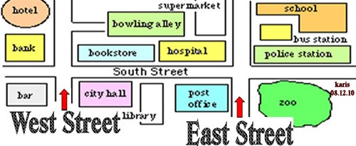
What direction goes in the yellow box?

1

North

2

South

3

East

4

West

6

Multiple Choice

Question image

What is the biggest country in South America?

1

Peru

2

Chile

3

Brazil

7

Multiple Choice

Question image

Brazil is on the equator. Do you think it's hot or cold there?

1

Hot

2

Cold

8

Multiple Choice

Question image

On what continent is Brazil?

1

North America

2

South America

3

Europe

9

Multiple Choice

Question image
In which direction would you have to travel to go from the bank to the hospital?
1
North
2
South
3
East
4
West

10

Multiple Choice

Question image
The hotel is ____________ of the zoo.
1
North 
2
South
3
East
4
West

11

Multiple Choice

Question image
What is the name of this object, which can be found on most maps?
1
directions lily
2
compass rose
3
compass orchid
4
fleur de lis

12

Multiple Choice

Question image
Northeast, Southeast, Northwest, and Southwest are all known as ____________________ directions.
1
main
2
cardinal
3
four
4
intermediate

13

Multiple Choice

Question image
North, South, East and West are all called the ____________________ directions.
1
main
2
cardinal
3
four
4
intermediate

14

Multiple Choice

Question image

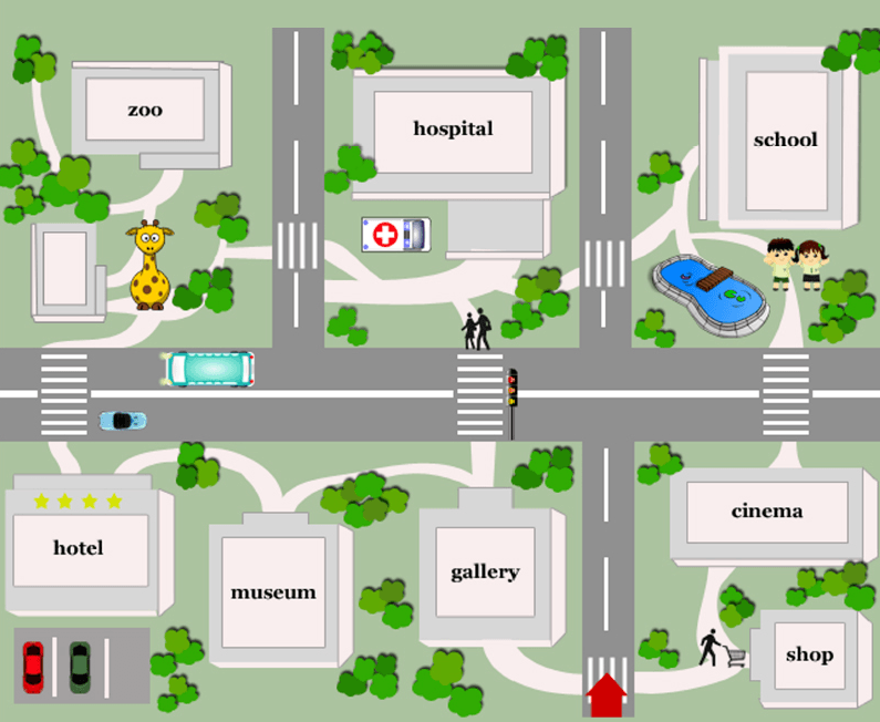
Which country is highlighted in blue

1

Japan

2

Brazil

3

Canada

4

Australia

15

Multiple Choice

Which continent is the largest?

1

Asia

2

Africa

3

Antarctica

4

Australia

16

Multiple Choice

How many continents are there?

1

6

2

5

3

7

4

4

17

Multiple Choice

What line of Latitude lies at 23.5 degrees South of the Equator?

1

Tropic of Cancer

2

Tropic of Capricorn

3

The Antarctic Circle

4

The Arctic Circle

18

Multiple Choice

What line of Longitude runs at 180 degrees

1

The Prime Meridian

2

The Tropic of Cancer

3

The International Dateline

4

The Equator

19

Multiple Choice

In which hemisphere would New Zealand be in

1

North West

2

South West

3

North East

4

South East

20

Multiple Choice

In which hemisphere would the USA be in.

1

South East

2

North West

3

North East

4

South West

21

Multiple Choice

Which line of Latitude is furthest South

1

The Equator

2

The Arctic Circle

3

The Antarctic Circle

4

The Tropic of Capricorn

22

Multiple Choice

Which line of Latitude is further North

1

The Tropic of Cancer

2

The Tropic of Capricorn

3

The Equator

4

The Antarctic Circle

23

Multiple Choice

What line runs at 0 degrees Longitude

1

The Equator

2

The Tropic of Cancer

3

The Tropic of Capricorn

4

The Greenwich (Prime) Meridian

24

Multiple Choice

What line runs at 0 degrees latitude

1

The Arctic Circle

2

The Prime Meridian

3

The Equator

4

The Tropic of Capricorn

25

Multiple Choice

What lines run vertically (Up and Down) around the globe

1

Latitude

2

Longitude

26

Multiple Choice

What lines run horizontally (Side to Side) around the globe

1

Latitude

2

Longitude

Bahamian Social Studies World Mapping

Slide image

Show answer

Auto Play

Slide 1 / 26

SLIDE