
Notes 1.2-1.3
Presentation
•
Geography
•
9th - 12th Grade
•
Practice Problem
•
Easy

Steven Taylor
Used 2+ times
FREE Resource
20 Slides • 2 Questions
1

2

Patterns and Spatial Organization (PSO)
•Why do geographers study relationships and patterns among and between places?
Impacts and Interactions (IMP)
•How do geographers use maps to help them discover patterns and relationships in the world?
Spatial Processes and Societal Change (SPS)
•How do geographers use a spatial perspective to analyze complex issues and relationships?
3

Enduring Understanding Imp
-
1
By the end of this section, you will understand that geographers use maps and data to depict relationships of time, space, and scale.
4

Carli Terrell, Orange County Public Schools
5


Objectives and Essential Learning
1.2 Identify different methods of geographic data collection.
●1.2.1 Data may be gathered in the field by organizations or by individuals.
●1.2.2 Geospatial technologies include geographic information systems (GIS), satellite
navigation systems, remote sensing, and online mapping and visualization.
●1.2.3 Spatial information can come from written accounts in the form of field observations,
media reports, travel narratives, policy documents, personal interviews, landscape analysis,
and photographic interpretation.
1.3 Explain the geographic effects of decisions made using geographical information.
●1.3.1 Geospatial and geographical data, including census data and satellite imagery, are
used at all scales for personal, business and organizational, and governmental decision-
making purposes.
6


Identify different methods of geographic data collection.
1.How is data gathered?
a. Fieldwork/Field Observations: The act of an
individual physically visiting a location or place
and recording, firsthand, information there.
i.Examples: Written accounts, travel narratives,
media reports, policy documents, interviews,
photographs, landscape analysis
7

Spatial information can come from written accounts in the form of field
observations, media reports, travel narratives, policy documents, personal
interviews, landscape analysis, and photographic interpretation.
Landscape Analysis
•Comes from older Germanic that
refers to the “shape” of the land.
•The word can imply a specific
area such as a "desert landscape".
•Goal is to study and describe a landscape to determine the impact of humans on that space.
8

Identify different methods of geographic data collection.
Another example of fieldwork - The US Census
▪Mandated by the Constitution
▪Ex. of an organization (US government) doing
fieldwork.
What is the point?
a.Representative Districts - voting & democracy
b.Distribution of public funding for:
i.Schools
ii.Law Enforcement & Fire Department
iii. Highways & Infrastructure
c.Personal, government & business decision making.
9


Identify different methods of geographic data collection.
b.
Geospatial Technologies
▪Geographic information systems (GIS)
▪Satellite navigation systems (GPS)
▪Remote sensing
▪Online mapping + visualizations
Geospatial technologies are utilized by
businesses, organizations, individuals and
government agencies to make decisions.
10


Identify different methods of geographic data collection.
Geographic Information Systems (GIS)
●
Computer system/software that stores,
analyzes, and displays information from
multiple digital maps or data sets.
● Thematic and physical layers
● Could be used for…
○ Analysis of crime data
○ Effects of pollution
○ Urban planning
11


12


Identify different methods of geographic data collection.
Satellite Navigation Systems/Global Positioning System (GPS)
Description: GPS receivers on Earth’s surface
use the locations of multiple satellites to determine and record a receiver's exact location.
Uses:precisely locating border; navigating
ships, aircraft, and cars; mapping lines (trails) or points (fire hydrants). Absolute location
Aerial Photography
● Professional images captured from planes or drones.
13


14


15

16


Identify different methods of geographic data collection.
Remote Sensing
The word remote means “from a distance”. Think
about turning on a TV using a remote instead of
directly turning it on using the buttons on the
device itself.
●The use of cameras or other sensors mounted on aircraft or satellites which orbit the earth above the atmosphere to collect digital images of the earth’s surface.
●Examples:
○Monitoring environmental changes
○Weather
17


In order to circumvent the unwillingness of the North Korean authorities to allow human rights
investigators access, Amnesty International and others have used remote sensing tools, such as
satellite imagery, to provide more information about the human rights situation in North Korea.
Previous satellite image analysis released by Amnesty International suggests the use and expansion
of North Korea’s notorious political prison camps, and the blurring of the boundary between kwanliso 14 and surrounding villages.
Example of
Remote Sensing:
North Korean
Prison Camps
“We worked in the farms (at kwanliso 15) from 7am to
8pm. We cultivated corn. We were divided to work in
units comprising 10-15 people each. We were given a
daily production target that we had to meet. If the unit
did not meet the daily target, the unit-members were
punished collectively. During the course of our three-
year detention, often we did not meet our targets
because we were always hungry and weak. We were
punished with beatings and also reductions in our food
quota. In addition to that, in the Ideology Struggle
Sessions that were held after work, those who did not
meet the target were severely criticized and beaten by
other inmates.”
18

Spatial information can come from written accounts in the form of field observations, media reports, travel narratives, policy documents, personal interviews, landscape analysis, and photographic interpretation.
Photographic Interpretation
•Also known as aerial photography;
involves examing photographs for the purpose of identifying images and judging their significance.
•Most of these photos come from
planes or satellite images.
19

Geospatial data can be both quantitative and qualitative.
•Often used with GIS because it lends itself to analysis using formulas and computers.
Quantitative Data – information that can be measured and
recorded using numbers.
20

Geospatial data can be both quantitative and qualitative.
•Information is harder to
analyze because it includes
peoples’ perceptions, and
reasons.
•Yet it contributes to
geographic understanding of
places and the people who
use them.
Qualitative Data – normally collected as interviews, document
archives, descriptions, and visual observations.
21
Open Ended
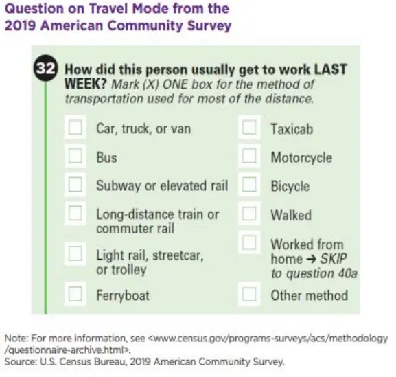
A. Identify the source of data on commuting in the United States.
B. Explain how the government agencies might use data about commuting in the United States.
22
Open Ended
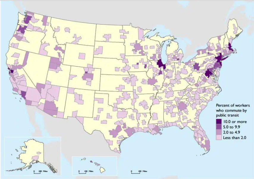
The map shows the percentage of people in metropolitan areas who commuted using public transportation from 2010–2014.
A. Identify the map as a reference or thematic map.
B. Describe spatial patterns in public transportation in American metropolitan areas.
Show answer
Auto Play
Slide 1 / 22
SLIDE
Similar Resources on Wayground

17 questions
Factoring Trinomials a = 1 Lesson
Presentation
•
9th - 12th Grade
17 questions
4.2 - Quadratics in Standard Form
Presentation
•
9th - 12th Grade
18 questions
Types of Business
Presentation
•
9th - 12th Grade
18 questions
Weather and Climate
Presentation
•
9th - 12th Grade
16 questions
Cell Theory
Presentation
•
9th - 12th Grade
16 questions
Intro to Nuclear Chemistry
Presentation
•
9th - 12th Grade
19 questions
Types of Governments
Presentation
•
9th - 12th Grade
13 questions
5 Themes of Geography
Presentation
•
9th - 12th Grade
Popular Resources on Wayground
16 questions
Grade 3 Simulation Assessment 2
Quiz
•
3rd Grade
19 questions
HCS Grade 5 Simulation Assessment_1 2526sy
Quiz
•
5th Grade
10 questions
Cinco de Mayo Trivia Questions
Interactive video
•
3rd - 5th Grade
17 questions
HCS Grade 4 Simulation Assessment_2 2526sy
Quiz
•
4th Grade
24 questions
HCS Grade 5 Simulation Assessment_2 2526sy
Quiz
•
5th Grade
13 questions
Cinco de mayo
Interactive video
•
6th - 8th Grade
20 questions
Math Review
Quiz
•
3rd Grade
30 questions
GVMS House Trivia 2026
Quiz
•
6th - 8th Grade
Discover more resources for Geography
20 questions
AP Human Geography Exam Review (Most Missed Past Exam Questions)
Quiz
•
9th Grade
45 questions
AP Human Geography Exam Review (Most Missed Past Exam Questions)
Quiz
•
9th Grade
46 questions
AP Human Geography Unit 4 Review
Quiz
•
9th - 12th Grade
50 questions
East Asia Unit 13 Exam Review
Quiz
•
9th Grade
10 questions
Oceania Regions and Cultural Traits
Interactive video
•
6th - 12th Grade
26 questions
AP Human Geography Unit 1
Quiz
•
9th Grade
41 questions
AP Human Geography Exam Review
Quiz
•
11th - 12th Grade
50 questions
AP Human Geography Exam Review (Units 1-7)
Quiz
•
9th - 10th Grade