Mapping Skills: Latitude and Longitude
Authored by Frank Singer
Social Studies
5th Grade
Used 1+ times

AI Actions
Add similar questions
Adjust reading levels
Convert to real-world scenario
Translate activity
More...
Content View
Student View
9 questions
Show all answers
1.
MULTIPLE CHOICE QUESTION
30 sec • 1 pt
What is the purpose of latitude lines on a map?
To measure distances east and west of the Prime Meridian
To measure distances north and south of the Equator
To indicate elevation above sea level
To show time zones
2.
MULTIPLE CHOICE QUESTION
30 sec • 1 pt
Which of the following is the latitude of the Equator?
3.
MULTIPLE CHOICE QUESTION
30 sec • 1 pt
What is the longitude of the Prime Meridian?
4.
MULTIPLE CHOICE QUESTION
30 sec • 1 pt
What is the purpose of a map legend?
To provide a scale for measuring distances
To explain the symbols and colors used on the map
To show the direction of north
To indicate latitude and longitude
5.
MULTIPLE CHOICE QUESTION
30 sec • 1 pt
Which of the following coordinates is closest to the North Pole?
6.
MULTIPLE CHOICE QUESTION
30 sec • 1 pt
What does the term "geographic coordinates" refer to?
The system of using symbols to represent features on a map
The system of using latitude and longitude to determine a location
The system of using colors to indicate different elevations
The system of using time zones to determine local time
7.
MULTIPLE CHOICE QUESTION
30 sec • 1 pt
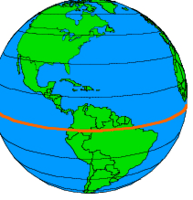
What is the 0-degree latitude line known as?
Prime Meridian
Equator
Tropic of Capricorn
Arctic Circle
Answer explanation
The 0-degree latitude line is known as the Equator, which divides the Earth into the Northern and Southern Hemispheres.

Access all questions and much more by creating a free account
Create resources
Host any resource
Get auto-graded reports
Continue with Google

Continue with Email
Continue with Microsoft
or continue with

%20(1).png)
Apple
Others
Already have an account?
