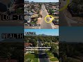
Tree Equity and Urban Heat
Interactive Video
•
Geography
•
9th - 10th Grade
•
Practice Problem
•
Hard

Olivia Brooks
FREE Resource
Read more
6 questions
Show all answers
1.
MULTIPLE CHOICE QUESTION
30 sec • 1 pt
What tool was used to capture the temperature differences in Phoenix neighborhoods?
A weather balloon
A satellite
A thermal drone
A handheld thermometer
2.
MULTIPLE CHOICE QUESTION
30 sec • 1 pt
Why do poorer neighborhoods in Phoenix have higher temperatures?
They are at a lower altitude
They are located closer to the equator
They have more industrial activity
They have fewer plants and trees
3.
MULTIPLE CHOICE QUESTION
30 sec • 1 pt
What is one reason residents in poorer neighborhoods do not plant trees?
Trees do not grow well in the area
Lack of interest in gardening
High cost of tree maintenance
They do not own the land
4.
MULTIPLE CHOICE QUESTION
30 sec • 1 pt
What is a significant factor that helps wealthier neighborhoods stay cooler?
More vegetation
Higher altitude
Better air conditioning
Proximity to water bodies
5.
MULTIPLE CHOICE QUESTION
30 sec • 1 pt
What term is used to describe the disparity in tree distribution between neighborhoods?
Tree disparity
Tree equity
Tree inequality
Tree imbalance
6.
MULTIPLE CHOICE QUESTION
30 sec • 1 pt
What resource is available for U.S. residents to check tree distribution in their area?
A local community center
A dedicated website
A mobile app
A government hotline
Access all questions and much more by creating a free account
Create resources
Host any resource
Get auto-graded reports
Continue with Google

Continue with Email
Continue with Classlink
Continue with Clever
or continue with
Microsoft
%20(1).png)
Apple
Others
Already have an account?
