
10 Q
1st - PD
8 Q
7th - 8th
16 Q
6th - 10th
10 Q
8th - 12th
11 Q
7th - 12th
25 Q
6th - Uni
14 Q
1st - 10th
7 Q
8th
20 Q
8th
11 Q
8th
10 Q
6th - 8th
51 Q
8th - Uni
10 Q
8th
8 Q
7th - 8th
15 Q
6th - 10th
12 Q
8th - 9th
23 Q
7th - 9th
16 Q
8th
15 Q
7th - 9th
25 Q
8th
10 Q
6th - 8th
18 Q
6th - Uni

7 Q
8th
6 Q
7th - 12th
Explore Orienteering Worksheets by Grades
Explore Other Subject Worksheets for year 8
Explore printable Orienteering worksheets for Year 8
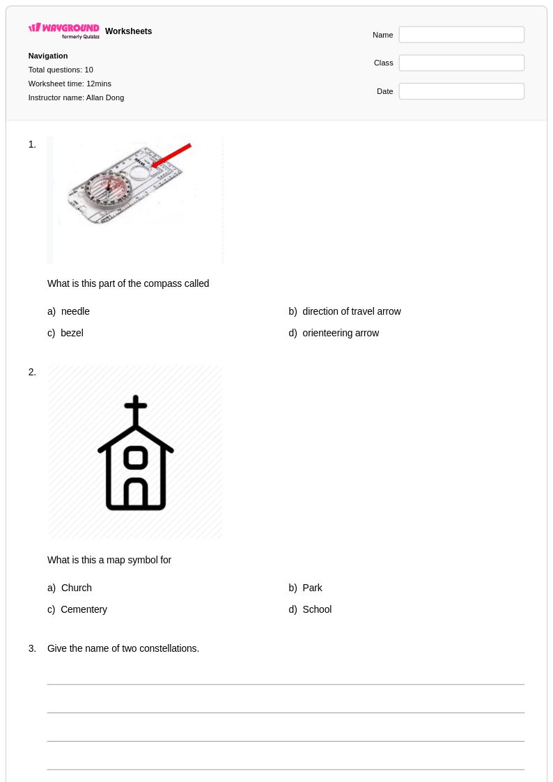
Orienteering worksheets for Year 8 students available through Wayground (formerly Quizizz) provide comprehensive skill-building opportunities that develop essential navigation and outdoor adventure competencies. These educational resources focus on teaching students how to read topographic maps, use compass bearings, interpret contour lines, and navigate through unfamiliar terrain using map and compass techniques. The worksheets strengthen critical thinking abilities as students practice calculating distances, determining elevation changes, and plotting courses between control points. Each printable resource includes detailed practice problems that challenge students to apply orienteering principles in realistic scenarios, while accompanying answer keys allow for immediate feedback and self-assessment. These free educational materials serve as valuable supplements to hands-on outdoor experiences, helping students master the theoretical foundations of orienteering before applying these skills in field settings.
Wayground (formerly Quizizz) supports Physical Education teachers with an extensive collection of teacher-created orienteering resources drawn from millions of educational materials developed by experienced educators worldwide. The platform's robust search and filtering capabilities enable teachers to quickly locate Year 8 appropriate worksheets that align with specific curriculum standards and learning objectives for outdoor and adventure activities. Teachers can easily differentiate instruction by selecting materials that match individual student needs, whether for remediation of basic map reading skills or enrichment through advanced navigation challenges. The flexible customization tools allow educators to modify existing worksheets or combine multiple resources to create comprehensive orienteering units, while the availability of both printable pdf formats and digital versions ensures seamless integration into any classroom environment. This versatility supports effective lesson planning and provides teachers with reliable resources for ongoing skill practice and assessment in orienteering education.
FAQs
How do I teach orienteering to students who have never used a compass before?
What exercises help students practice reading topographic maps for orienteering?
What mistakes do students commonly make when learning compass navigation?
How do I differentiate orienteering instruction for students with varying experience levels?
How can I use Wayground's orienteering worksheets in my PE class?
How do I assess whether students understand orienteering safety protocols?