

Wayground
US States & Capitals - Printable Geography Worksheets - Wayground

US States & Capitals

50 questions

7th - 7th Grade

Geography

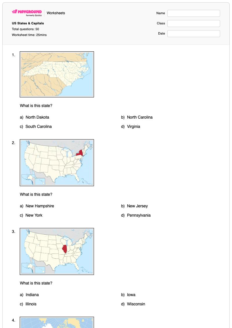
US States & Capitals is a Grade 7 geography worksheet that helps students identify U.S. states from visual state-identification prompts. It contains 50 multiple-choice questions, with each item asking students to select the correct state from a group of options that may include neighboring or similarly named states such as North Carolina and South Carolina, or regional choices such as Kansas, Nebraska, and South Dakota. The worksheet focuses on recognizing individual states rather than recalling state capitals. Use this free printable worksheet for geography practice, independent work, review, or a formative check of students’ U.S. map knowledge. Students build accuracy by comparing visual state clues with multiple answer choices and distinguishing states across the Southeast, Midwest, Northeast, West, and other regions represented in the questions. A complete answer key is included to support efficient checking and feedback.

Worksheet settings

Font size

S
M
L
XL
Worksheets

US States & Capitals

Total questions: 50

Name
Class
Date
1.

What is this state?

a)

North Dakota

b)

North Carolina

c)

South Carolina

d)

Virginia

2.

What is this state?

a)

New Hampshire

b)

New Jersey

c)

New York

d)

Pennsylvania

3.

What is this state?

a)

Indiana

b)

Iowa

c)

Illinois

d)

Wisconsin

4.

What is this state?

a)

Utah

b)

Colorado

c)

Nevada

d)

Wyoming

5.

What is this state?

a)

Arizona

b)

California

c)

Colorado

d)

New Mexico

6.

What is the state?

a)

Missouri

b)

Wisconsin

c)

Minnesota

d)

Illinois

7.

What is this state?

a)

Oklahoma

b)

Arkansas

c)

Louisiana

d)

Oregon

8.

What is this state?

a)

Washington

b)

Oregon

c)

Montana

d)

Idaho

9.

What is this state?

a)

Alaska

b)

Hawaii

c)

California

d)

Florida

10.

What is this state?

a)

Massachusetts

b)

Maryland

c)

New Hampshire

d)

Maine

11.

What is this state?

a)

Minnesota

b)

Michigan

c)

Wisconsin

d)

Ohio

12.

What is this state?

a)

Nebraska

b)

Kansas

c)

South Dakota

d)

Colorado

13.

What is this state?

a)

Georgia

b)

Alabama

c)

Mississippi

d)

South Carolina

14.

What is this state?

a)

Virginia

b)

Kentucky

c)

West Virginia

d)

North Carolina

15.

What is this state?

a)

Florida

b)

California

c)

Hawaii

d)

Georgia

16.

What is the capital of this state?

a)

Nashville

b)

Memphis

c)

Frankfurt

d)

Charleston

17.

What is the capital of Delaware?

a)

Trenton

b)

Dover

c)

Harrisburg

d)

Augusta

18.

What is the capital of this state?

a)

Concord

b)

Hartford

c)

Harrisburg

d)

Montpelier

19.

What is the capital of this state?

a)

Pierre

b)

Bismarck

c)

Helena

d)

Fargo

20.

What is the capital of this state?

a)

Salem

b)

Portland

c)

Seattle

d)

Olympia

21.

What is the capital of this state?

a)

Honolulu

b)

Olympia

c)

Juneau

d)

Anchorage

22.

What is the capital of this state?

a)

Annapolis

b)

Baltimore

c)

Richmond

d)

Boston

23.

What is the capital of this state?

a)

Charleston

b)

Columbia

c)

Richmond

d)

Raleigh

24.

What is the capital of this state?

a)

Columbia

b)

Springfield

c)

St. Louis

d)

Jefferson City

25.

What is the capital of this state?

a)

Baton Rouge

b)

New Orleans

c)

Montgomery

d)

Little Rock

26.

What is this state?

a)

Wyoming

b)

Colorado

c)

Montana

d)

Utah

27.

What is this state?

a)

Mississippi

b)

Louisiana

c)

Georgia

d)

Alabama

28.

What is this state?

a)

Illinois

b)

Indiana

c)

Ohio

d)

Michigan

29.

What is this state?

a)

Maryland

b)

Connecticut

c)

Rhode Island

d)

Massachusetts

30.

What is this state?

a)

Nebraska

b)

Kansas

c)

South Dakota

d)

Iowa

31.

What is this state?

a)

Rhode Island

b)

Connecticut

c)

Massachusetts

d)

New Hampshire

32.

What is this state?

a)

Missouri

b)

Kansas

c)

Arkansas

d)

Louisiana

33.

What is this state?

a)

New Jersey

b)

Vermont

c)

New Hampshire

d)

Maine

34.

What is this state?

a)

North Dakota

b)

Montana

c)

Nebraska

d)

Idaho

35.

What is this state?

a)

Colorado

b)

Wyoming

c)

Utah

d)

Nebraska

36.

What is the capital of this state?

a)

Boise

b)

Billings

c)

Helena

d)

Cheyenne

37.

What is the capital of this state?

a)

Harrisburg

b)

Hartford

c)

Pittsburgh

d)

Trenton

38.

What is the capital of New Mexico?

a)

Albuquerque

b)

Phoenix

c)

Santa Fe

d)

San Diego

39.

What is the capital of this state?

a)

Cheyenne

b)

Carson City

c)

Las Vegas

d)

Trenton

40.

What is the capital of this state?

a)

Des Moines

b)

Iowa City

c)

Davenport

d)

Cedar Rapids

41.

What is this state?

a)

Arizona

b)

New Mexico

c)

Utah

d)

Nevada

42.

What state borders Kansas to the north?

a)

Nebraska

b)

Arkansas

c)

Oklahoma

d)

Colorado

43.

What state borders Iowa to the north?

a)

Missouri

b)

Minnesota

c)

Illinois

d)

Nebraska

44.

What state borders Florida to the north?

a)

Georgia

b)

South Carolina

c)

Mississippi

d)

Maryland

45.

What is this state?

a)

Indiana

b)

Arkansas

c)

Ohio

d)

Connecticut

46.

What is the capital of Washington?

a)

Salem

b)

Seattle

c)

Olympia

d)

Helena

47.

What is this state?

a)

New Hampshire

b)

Delaware

c)

Vermont

d)

New Jersey

48.

Which of the following states is furthest east?

a)

Virginia

b)

Ohio

c)

Louisiana

d)

Michigan

49.

Which of the following states is part of the South?

a)

Iowa

b)

Wisconsin

c)

South Dakota

d)

Mississippi

50.

Which of the following states is furthest north?

a)

Louisiana

b)

Colorado

c)

Indiana

d)

Montana

Answer Key

US States & Capitals

Total questions: 50

1.
b)

North Carolina

2.
c)

New York

3.
c)

Illinois

4.
a)

Utah

5.
b)

California

6.
c)

Minnesota

7.
a)

Oklahoma

8.
a)

Washington

9.
b)

Hawaii

10.
d)

Maine

11.
b)

Michigan

12.
b)

Kansas

13.
a)

Georgia

14.
c)

West Virginia

15.
a)

Florida

16.
a)

Nashville

17.
b)

Dover

18.
d)

Montpelier

19.
a)

Pierre

20.
a)

Salem

21.
c)

Juneau

22.
a)

Annapolis

23.
b)

Columbia

24.
d)

Jefferson City

25.
a)

Baton Rouge

26.
a)

Wyoming

27.
d)

Alabama

28.
b)

Indiana

29.
d)

Massachusetts

30.
a)

Nebraska

31.
b)

Connecticut

32.
c)

Arkansas

33.
c)

New Hampshire

34.
a)

North Dakota

35.
a)

Colorado

36.
a)

Boise

37.
a)

Harrisburg

38.
c)

Santa Fe

39.
b)

Carson City

40.
a)

Des Moines

41.
a)

Arizona

42.
a)

Nebraska

43.
b)

Minnesota

44.
a)

Georgia

45.
c)

Ohio

46.
c)

Olympia

47.
d)

New Jersey

48.
a)

Virginia

49.
d)

Mississippi

50.
d)

Montana

FAQs

What does the US States & Capitals worksheet help students practice?

This Grade 7 geography worksheet helps students identify individual U.S. states from visual state-identification prompts. Across 50 multiple-choice questions, students compare each prompt with four state-name options and distinguish states such as California, Washington, Michigan, Georgia, and West Virginia from plausible alternatives.

How can I use this worksheet to teach U.S. state identification?

Introduce the worksheet by modeling how to study the visual clues in a state prompt before reading all four answer choices. Have students explain why their selected state fits and why the other options do not, then use the Southeast, Midwest, Northeast, and Western examples in the questions to review regional location patterns.

What mistakes should I watch for when students complete this state-identification worksheet?

Students may select a state from the correct general region without distinguishing its exact outline or location, especially when options include neighboring states. Watch for confusion between similarly named choices, such as North Carolina and South Carolina, and between states grouped together from the Midwest or Mountain West.

How do I assign and grade this US States & Capitals worksheet?

The worksheet is available as a printable PDF and as a digital quiz on Wayground, and it includes a complete answer key for all 50 multiple-choice questions. For printed submissions, scan student work with the Wayground for Teachers app to grade it efficiently.

How can I differentiate this state-identification worksheet for my students?

In the worksheet’s Advanced Settings, adjust font spacing and font size to make the 50 multiple-choice state-identification items easier to read. You can also apply a dyslexia-friendly font or translate the worksheet into another language while keeping the state-name answer choices intact.

Where can I find more free worksheets like this on Wayground?

Wayground offers a broad collection of free printable worksheets and practice problems across subjects, with downloadable PDFs and answer keys to support essential skills and concepts. Browse more resources at https://wayground.com/en-us/worksheets.