Free Printable Earth Science Worksheets for Grade 8
Grade 8 Earth Science worksheets from Wayground offer comprehensive printables and practice problems that help students master fundamental concepts including geology, meteorology, and oceanography with detailed answer keys and free PDF resources.
Explore printable Earth Science worksheets for Grade 8
Grade 8 Earth Science worksheets available through Wayground (formerly Quizizz) provide comprehensive coverage of fundamental geological concepts, atmospheric processes, and planetary systems that form the foundation of earth science education. These expertly crafted resources strengthen students' understanding of rock cycles, plate tectonics, weather patterns, climate systems, and Earth's place in the solar system through engaging practice problems that challenge critical thinking and scientific reasoning. Each worksheet collection includes detailed answer keys that support both independent study and guided instruction, while printable pdf formats ensure easy classroom distribution and flexible implementation across diverse learning environments. These free educational resources emphasize hands-on application of scientific principles, helping students develop essential skills in data interpretation, scientific observation, and evidence-based reasoning that are crucial for success in advanced earth science coursework.
Wayground (formerly Quizizz) empowers educators with an extensive library of millions of teacher-created earth science resources specifically designed to meet the rigorous academic demands of Grade 8 curriculum standards. The platform's sophisticated search and filtering capabilities enable teachers to quickly locate materials aligned with specific learning objectives, whether focusing on geological processes, atmospheric science, or space exploration concepts. Advanced differentiation tools allow for seamless customization of worksheet difficulty levels, supporting both remediation for struggling learners and enrichment opportunities for advanced students. Available in both digital and printable formats, these versatile resources integrate effortlessly into lesson planning workflows, providing teachers with reliable materials for skill-building practice, formative assessment, and targeted intervention strategies that enhance student mastery of complex earth science principles.
FAQs
How do I teach the rock cycle to middle school students?
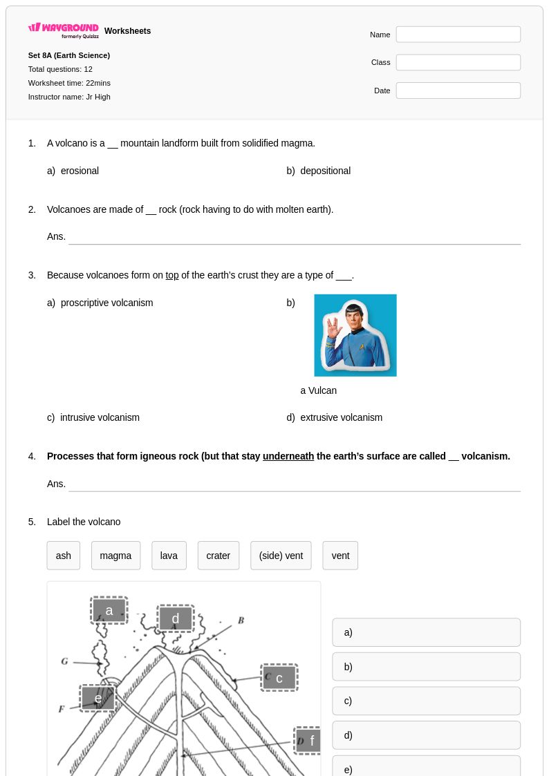
Start with hands-on sorting activities where students categorize igneous, sedimentary, and metamorphic rock samples by observable properties before introducing cycle diagrams. From there, progress to labeling and tracing activities that show how rocks transition between types through processes like melting, cooling, compaction, and heat and pressure. A common pitfall is letting students believe the rock cycle follows one fixed sequence — emphasize that rocks can enter and exit the cycle at multiple points depending on environmental conditions.
What exercises help students practice reading weather and climate data?
Graph analysis activities are especially effective — have students interpret temperature and precipitation charts, compare climate data across regions, and identify seasonal patterns from real or simulated datasets. Worksheets that ask students to connect weather variables (air pressure, humidity, wind direction) to observed outcomes build the analytical thinking needed for both assessments and real-world science reasoning. Progressing from simple bar graphs to multi-variable climate comparisons keeps practice appropriately challenging across grade levels.
What mistakes do students commonly make when learning about plate tectonics?
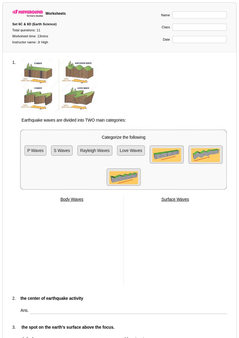
One of the most persistent misconceptions is that earthquakes only occur along visible surface fault lines — students often don't understand that seismic activity originates at depth and that fault lines may not be visible at the surface. Students also frequently confuse the three types of plate boundaries (convergent, divergent, transform) and struggle to connect boundary type to the geological features it produces, such as mountain ranges, rift valleys, or oceanic trenches. Worksheets that ask students to interpret plate boundary diagrams and match them to real-world landforms help address both issues.
How do I help students distinguish between weathering and erosion?
Weathering and erosion are among the most commonly confused concepts in earth science because they are closely related and often occur together. Weathering is the breakdown of rock in place — either chemically or mechanically — while erosion is the transport of that material by wind, water, ice, or gravity. Use side-by-side comparison activities and real-world image analysis to anchor the distinction, and design practice problems that require students to identify which process is occurring and what agent is responsible.
How can I use Earth Science worksheets to support students with different learning needs?
Earth science spans multiple complex systems — geology, meteorology, hydrology, and tectonics — so differentiation is especially important for keeping all learners engaged. On Wayground, teachers can assign individual accommodations such as extended time, read-aloud support for students who need audio access to questions, and reduced answer choices to lower cognitive load for students who are still building foundational knowledge. These settings can be applied to individual students without notifying the rest of the class, so differentiated support stays discreet and consistent across sessions.
How do I use these Earth Science worksheets in my classroom?
Wayground's earth science worksheets are available as printable PDFs for traditional classroom use and in digital formats for technology-integrated learning environments, including the option to host them as interactive quizzes directly on Wayground. Printable versions work well for lab practical companions and in-class review, while digital formats allow for immediate feedback and easier progress tracking. Complete answer keys are included with every worksheet, supporting both teacher-led assessment and independent student review.
How do I connect multiple earth science processes in a single lesson or assessment?
Multi-process problems that require students to connect tectonics, weathering, erosion, and deposition into a coherent geological narrative are the most effective way to assess deep understanding rather than isolated recall. For example, a well-designed prompt might ask students to explain how a mountain range forms through plate collision, then breaks down through weathering, and eventually contributes sediment to a river delta. Building toward these integrated tasks through scaffolded practice — starting with single-process labeling and progressing to multi-step analysis — helps students develop the conceptual framework needed for complex earth science reasoning.