Free Printable Panama Canal Worksheets for Class 7
Enhance Class 7 geography skills with free Panama Canal worksheets and printables that help students explore this engineering marvel's history, construction, and global impact through engaging practice problems and comprehensive answer keys.
Explore printable Panama Canal worksheets for Class 7
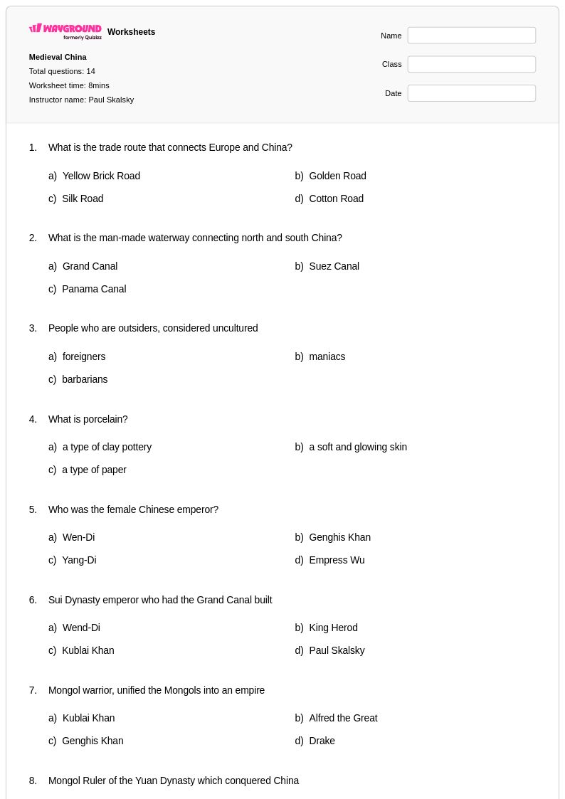
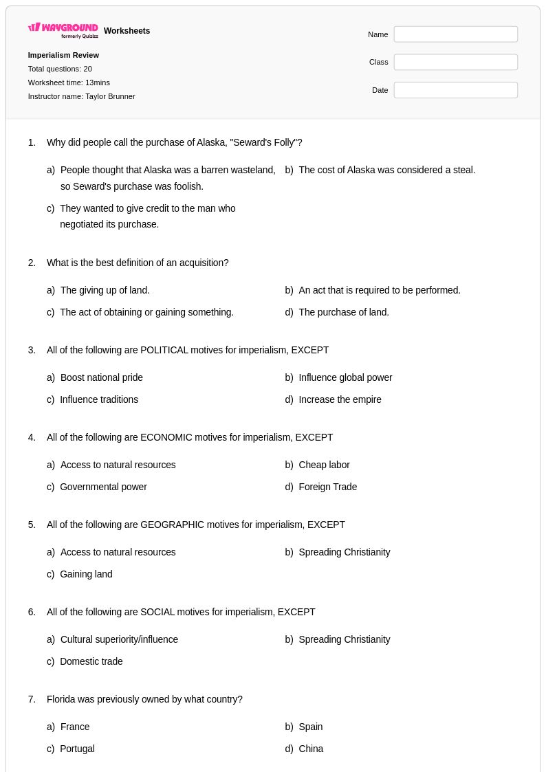
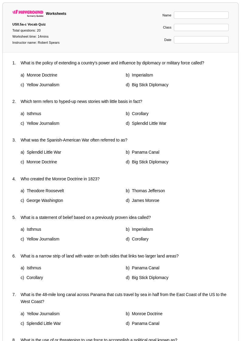
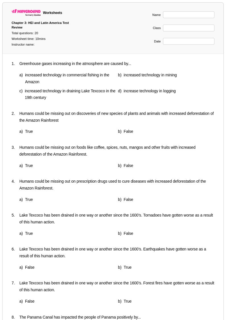
Panama Canal worksheets for Class 7 students available through Wayground (formerly Quizizz) provide comprehensive educational resources that explore one of the world's most significant engineering achievements and its profound impact on global geography and commerce. These expertly crafted worksheets strengthen critical thinking skills by engaging students with practice problems that examine the canal's strategic location, its role in connecting the Atlantic and Pacific oceans, and its influence on international trade routes and economic development. Students develop analytical abilities as they work through free printables that cover the canal's construction history, environmental considerations, and geopolitical significance, with each worksheet featuring detailed answer keys that support independent learning and allow educators to efficiently assess student understanding of this crucial geographic landmark.
Wayground (formerly Quizizz) empowers educators with an extensive collection of millions of teacher-created resources specifically designed to enhance Panama Canal instruction for Class 7 social studies curricula. The platform's robust search and filtering capabilities enable teachers to quickly locate standards-aligned materials that match their specific instructional needs, while differentiation tools allow for seamless customization to accommodate diverse learning levels within the classroom. These versatile worksheets are available in both printable and digital pdf formats, providing flexibility for various teaching environments and supporting effective lesson planning, targeted remediation for struggling learners, and enrichment opportunities for advanced students who need additional challenges in understanding the complex geographic and historical concepts surrounding this vital waterway.
FAQs
How do I teach the Panama Canal to middle or high school students?
Teaching the Panama Canal works best when you anchor the lesson in three interconnected lenses: engineering, geography, and global trade. Start with the problem the canal solved — the 8,000-mile detour ships had to make around South America — then move into how the lock system overcomes elevation changes to move vessels between oceans. Layering in primary sources, such as construction-era photographs or Roosevelt's correspondence, gives students concrete historical context before they analyze the canal's ongoing economic and political significance.
What are good practice activities for students learning about the Panama Canal?
Effective practice activities include map analysis exercises where students trace pre- and post-canal shipping routes and calculate distance differences, as well as document-based questions that ask students to evaluate construction challenges and political negotiations. Having students compare trade data before and after the canal's opening reinforces the concept of global economic impact in a measurable way. These tasks build geographic literacy and analytical writing skills simultaneously, which aligns with most social studies and history standards.
What mistakes do students commonly make when learning about the Panama Canal?
A common misconception is that the Panama Canal connects the Atlantic and Pacific oceans at the same elevation, when in fact ships are raised and lowered through a series of locks to navigate terrain that rises up to 85 feet above sea level. Students also frequently confuse the canal's location, assuming it runs east-to-west, when the geography of Panama actually means ships travel roughly northwest to southeast. Another frequent error is underestimating the political complexity of the canal's construction and ownership history, reducing it to a purely engineering story.
How do Panama Canal worksheets help students understand the lock system?
Panama Canal worksheets that include labeled diagrams and elevation-change problems give students a concrete visual model of how locks function as a water elevator, lifting and lowering ships rather than cutting a level channel through the terrain. Practice problems that ask students to sequence the steps a ship takes through the Gatun, Pedro Miguel, and Miraflores locks reinforce procedural understanding alongside geographic knowledge. This combination of diagram analysis and step-based reasoning is particularly effective for visual and sequential learners.
How can I use Wayground's Panama Canal worksheets in my classroom?
Wayground's Panama Canal worksheets are available as printable PDFs for traditional classroom use and in digital formats for technology-integrated or hybrid learning environments, and teachers can also host them as a quiz directly on Wayground. Each worksheet includes a complete answer key, so grading is efficient and feedback can be returned to students quickly. The digital format supports accommodations such as read aloud, extended time, and reduced answer choices, making the same materials accessible to students with diverse learning needs without requiring separate versions.
How do I differentiate Panama Canal lessons for students at different skill levels?
For foundational learners, focus on vocabulary and basic geography — identifying the canal on a map, defining locks, and sequencing key historical events. Intermediate students can move into cause-and-effect analysis, examining how the canal changed global shipping economics. Advanced students benefit from evaluating primary sources, analyzing trade data, and arguing positions on sovereignty and international control. On Wayground, teachers can apply individual accommodations such as extended time or reduced answer choices to specific students, so all learners can access the same core materials without requiring entirely separate worksheets.