Free Printable Physical Features Worksheets for Class 3
Explore Wayground's free Class 3 physical features worksheets and printables that help students learn about mountains, rivers, valleys, and other landforms through engaging practice problems with answer keys.
Explore printable Physical Features worksheets for Class 3
Physical features worksheets for Class 3 students available through Wayground (formerly Quizizz) provide comprehensive exploration of Earth's natural landforms and water bodies that shape our planet's surface. These educational resources guide young learners through identifying and understanding mountains, valleys, rivers, lakes, oceans, deserts, and plains while building essential geographic literacy skills. The practice problems within these worksheets strengthen students' ability to classify different physical features, interpret basic maps and diagrams, and connect landforms to their formation processes. Each worksheet collection includes detailed answer keys that support both independent learning and guided instruction, with free printables designed to accommodate various learning styles and classroom needs. These pdf resources emphasize hands-on learning through labeling activities, matching exercises, and visual identification tasks that help third-grade students develop spatial thinking and geographic vocabulary essential for social studies success.
Wayground's extensive collection of physical features worksheets draws from millions of teacher-created resources, ensuring educators have access to diverse, high-quality materials that align with grade-appropriate geography standards. The platform's robust search and filtering capabilities allow teachers to quickly locate worksheets targeting specific landforms or skill levels, while built-in differentiation tools enable customization for varying student abilities within the same classroom. These resources are available in both printable and digital formats, including downloadable pdf options that facilitate seamless integration into lesson planning and homework assignments. Teachers utilize these comprehensive worksheet collections for targeted skill practice, remediation support for struggling learners, and enrichment opportunities for advanced students, making physical features instruction more engaging and accessible. The platform's flexible customization features allow educators to modify existing worksheets or combine multiple resources to create comprehensive units that address diverse learning objectives and support standards-based geography instruction.
FAQs
How do I teach physical features of the Earth to students?
Teaching physical features works best when students move from identification to analysis — start by having students label and classify landforms such as mountains, rivers, plains, plateaus, and deserts on maps before examining how those features shape human activity in a region. Connecting physical geography to real-world examples, such as how river valleys support agriculture or how mountain ranges create natural borders, gives students a concrete framework for understanding why landforms matter beyond just naming them. Pairing map work with structured note-taking and practice problems reinforces both vocabulary and spatial reasoning.
What exercises help students practice identifying physical features?
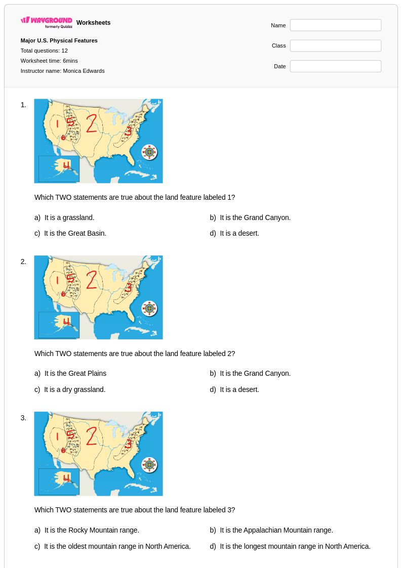
Effective practice exercises for physical features include map labeling activities, landform classification tasks, and diagram-based questions that ask students to identify and describe specific geographic characteristics. Worksheets that require students to match landforms to their definitions, locate examples on regional or world maps, and explain how features like plateaus differ from plains build both recognition and conceptual understanding. Repeated low-stakes practice with answer keys allows students to self-correct and internalize geographic vocabulary independently.
What mistakes do students commonly make when learning about physical features?
One of the most common errors is confusing landforms that share visual similarities, such as plateaus and plains, or hills and mountains, because students rely on general appearance rather than precise geographic criteria like elevation and formation. Students also frequently struggle to connect physical features to their broader geographic significance, treating landform identification as a memorization task rather than understanding how features like river deltas or mountain ranges influence climate, settlement, and economics. Targeted practice that requires students to explain the distinguishing characteristics of each landform, rather than simply name it, helps address these gaps.
How can I use physical features worksheets in my classroom?
Physical features worksheets on Wayground are available as printable PDFs for traditional classroom use and in digital formats for technology-integrated environments, including the option to host them as a quiz directly on Wayground. Printable versions work well for individual seat work, map annotation activities, or as homework reinforcement, while digital formats support self-paced review and immediate feedback. Both formats include answer keys, making them practical for independent student practice as well as teacher-led instruction.
How do physical features relate to human geography, and should I teach them together?
Physical features are foundational to understanding human geography because landforms, water systems, and terrain directly influence where people settle, how they earn a living, and how cultures develop over time. Teaching physical and human geography together — for example, examining why major cities often develop near rivers or coastal plains — gives students a more complete and meaningful picture of geographic relationships. Worksheets that ask students to analyze how specific landforms affect settlement patterns or economic activity make this connection explicit and build higher-order geographic thinking.
How do I differentiate physical features instruction for students at different ability levels?
For students who need additional support, simplifying tasks to focus on identifying and naming major landform categories before moving to analysis reduces cognitive overload and builds foundational vocabulary first. Advanced students benefit from tasks that require them to compare physical features across regions or evaluate how landforms have shaped historical events and economic patterns. On Wayground, teachers can apply accommodations such as reduced answer choices or read-aloud settings to individual students, allowing the same worksheet to serve multiple ability levels within a single class without drawing attention to those adjustments.