Free Printable World Climate and Climate Change Worksheets for Class 9
Class 9 world climate and climate change worksheets from Wayground help students explore global weather patterns, climate zones, and environmental impacts through engaging printables, practice problems, and comprehensive answer keys.
Explore printable World Climate and Climate Change worksheets for Class 9
World Climate and Climate Change worksheets for Class 9 students through Wayground provide comprehensive resources that help students understand global climate patterns, atmospheric systems, and the complex factors driving climate change across different regions. These carefully designed worksheets strengthen critical thinking skills as students analyze temperature and precipitation data, examine the relationship between latitude and climate zones, and evaluate human impacts on global weather systems. Each worksheet collection includes detailed answer keys and is available as free printables in pdf format, featuring practice problems that guide students through interpreting climate graphs, comparing biomes, and assessing the causes and consequences of climate variability and long-term climate shifts.
Wayground supports educators with millions of teacher-created resources specifically focused on world climate and climate change topics, offering robust search and filtering capabilities that allow teachers to quickly locate materials aligned with state and national geography standards. The platform's differentiation tools enable teachers to customize worksheets for varying ability levels within their Class 9 classrooms, while flexible formatting options provide both printable pdf versions for traditional assignments and digital formats for interactive learning experiences. These comprehensive worksheet collections streamline lesson planning by providing ready-to-use materials for skill practice, targeted remediation for students struggling with climate concepts, and enrichment activities that challenge advanced learners to explore complex climate-human interaction scenarios.
FAQs
How do I teach world climate zones and climate change in a geography class?
Start by grounding students in the five major climate zones (tropical, dry, temperate, continental, and polar) before introducing the mechanisms of climate change, such as greenhouse gas accumulation and albedo feedback loops. Use climate graphs and regional case studies to make abstract patterns concrete, then connect those patterns to observable changes like shifting precipitation zones and rising global temperatures. Comparing a stable historical climate record with recent anomaly data helps students build evidence-based reasoning rather than relying on memorization.
What exercises help students practice analyzing climate data and graphs?
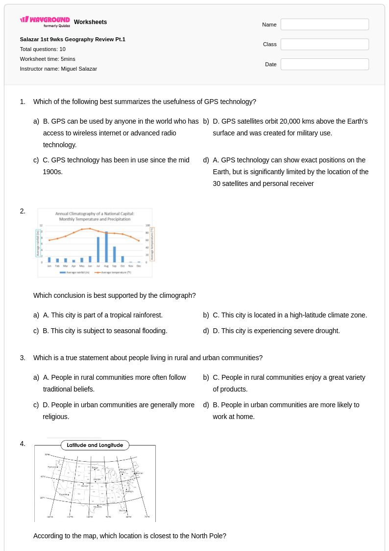
Exercises that ask students to interpret climographs, which display monthly temperature and precipitation together, are especially effective for building data literacy around climate. Students benefit from comparing two or more regional climographs to identify patterns, draw inferences about biome type, and explain the role of latitude, elevation, and ocean currents. Practice problems that require students to evaluate scientific evidence related to global warming, such as temperature anomaly charts or CO2 concentration graphs, extend these skills into climate change analysis.
What are the most common mistakes students make when learning about climate change?
The most persistent misconception is conflating weather with climate: students often cite a cold winter as evidence against global warming without understanding that climate describes long-term statistical patterns, not individual events. A second common error is treating climate change as a future threat rather than an ongoing process, which can be corrected by examining current data on sea level rise, Arctic ice extent, and shifting growing seasons. Students also frequently underestimate the role of human activity, so worksheets that explicitly connect fossil fuel combustion and deforestation to measurable atmospheric changes help address this gap.
How can I differentiate climate change worksheets for students at different skill levels?
For students who need additional support, reduce the complexity of data sets and provide sentence starters or graphic organizers that scaffold the analysis process. More advanced students can be challenged with open-ended evaluation tasks, such as assessing competing policy responses to climate change using scientific evidence. On Wayground, teachers can apply built-in accommodation settings, including reduced answer choices to lower cognitive load and read-aloud support for students who need text-to-speech, and these settings can be assigned to individual students without notifying the rest of the class.
How do I use Wayground's World Climate and Climate Change worksheets in my classroom?
Wayground's world climate and climate change worksheets are available as printable PDFs for traditional classroom use and in digital formats for technology-integrated or hybrid learning environments, including the option to host them as a quiz directly on Wayground. Each worksheet includes a complete answer key, so teachers can use them for independent practice, homework assignments, or formative assessment without additional preparation. The flexible format means the same material can be distributed on paper during in-person lessons or assigned digitally for remote or blended settings.
How do I connect climate change content to geography standards?
Climate change intersects with several core geography standards, particularly those covering human-environment interaction, spatial patterns in physical systems, and the use of geographic tools such as maps and data visualizations. Aligning worksheets to these standards is most effective when activities move students through three levels: describing observed climate patterns, explaining the physical and human causes of those patterns, and evaluating the geographic consequences of ongoing change. Framing climate change as a geographic issue, not only a science issue, helps students see its relevance to population movement, resource distribution, and regional economic stability.