wayground logo

Free Printable Worksheets

NEW

Font size

S
M
L
XL
Worksheets

Fall Exam Review

Total questions: 70

Worksheet time: 1hrs 3mins

Name
Class
Date
1.
 A way of describing where a place is located in relation to other landmarks or places is called its
a)
Absolute Location
b)
Place
c)
Human-Environment Interaction
d)
Relative Location
2.
__________ is a map that shows landforms, bodies of water, elevation.
a)
Political map
b)
Population density map
c)
Physical map
d)
Population distribution map
3.
A ____________________ map shows boundaries, cities, capitals etc.
a)
political
b)
physical
c)
topographical
d)
population
4.
The ______________ is/are the largest group group of fresh water lakes in the world.
a)
Great Salt Lake
b)
Great Slave Lake
c)
Great Bear Lake
d)
Great Lakes
5.
This symbol identifies which feature of a map?
a)
Orientation
b)
Contour
c)
Distance
d)
Projection
6.
Zero degrees latitude is also called the _______.      
a)
Tropic of Capricorn
b)
Equator
c)
Prime Meridian 
d)
Tropic of Cancer
7.
The Tropic of Cancer is located at ________ degrees North latitude.    
a)
23.5 
b)
66.5 
c)
 90
d)
 0 
8.
What is the following North American Physical Feature?
a)
Missouri River
b)
Ohio River
c)
Rio Grande 
d)
Rocky Mountains
9.
What city is located at 87 degrees W by 42 degrees N?
a)
Chicago
b)
Detroit
c)
St. Louis
d)
Atlanta
10.
What is the Absolute location of Los Angeles?
a)
118 degrees W by 36 degrees N
b)
118 degrees W by 34 degrees N
c)
118 degrees N by 36 degrees W
d)
118 degrees N by 34 degrees W
11.
What is a symbol that shows directions?
a)
compass rose
b)
map key
c)
scale
d)
inset map
12.
What tells what the map is about?
a)
map key
b)
index
c)
compass rose
d)
title
13.
What is Theocracy
a)
A political system based on fierce nationalism and a strong government.
b)
An individual holds complete political power
c)
The government is run by clergy which are religious leaders.
d)
The citizens hold power and rule through elected representatives.
14.
What do longitude lines indicate?
a)
distance north and south of the Equator
b)
distance north and south of the Prime Meridian
c)
distances east and west of the Equator
d)
distances east and west of the Prime Meridian
15.
What statement accurately descrobes the relationship between the Tropic of Cancer and the Tropic of Capricorn?
a)
The Tropic of Cancer is north of the Tropic of Capricorn.
b)
The Tropic of Cancer is south of the Tropic of Capricorn.
c)
The Tropic of Cancer is east of the Tropic of Capricorn.
d)
The Tropic of Cancer is west of the Tropic of Capricorn.
16.
When looking for absolute location, look for:
a)
north, close to, far, beside
b)
addresses and latitude and longitude
17.
A dry area of land that receives less than 10 inches of precipitation (rainfall) per year.
a)
Mountain
b)
Canyon
c)
Desert
d)
Prairie
18.
A large natural stream that flows and empties into another body of water.
a)
Lake
b)
River
c)
Ocean
d)
Swamp
19.
A piece of land that is surrounded by water on 3 sides. 
a)
Tributary
b)
Peninsula
c)
Island
20.
A piece of land surrounded by water.
a)
Island
b)
Peninsula
c)
Gulf
21.
A group or chain of islands clustered together in a sea or ocean.
a)
Islands
b)
Peninsula
c)
Archipelago
22.
What is this landform?
a)
lake
b)
peninsula
c)
hills
d)
mountain
23.
Which of the following would be considered pull factors for immigration?
a)
 Poverty and war
b)
 Better schools and political freedom
24.
What is a ruler that measures distance?
a)
compass rose
b)
index
c)
scale
d)
inset map
25.
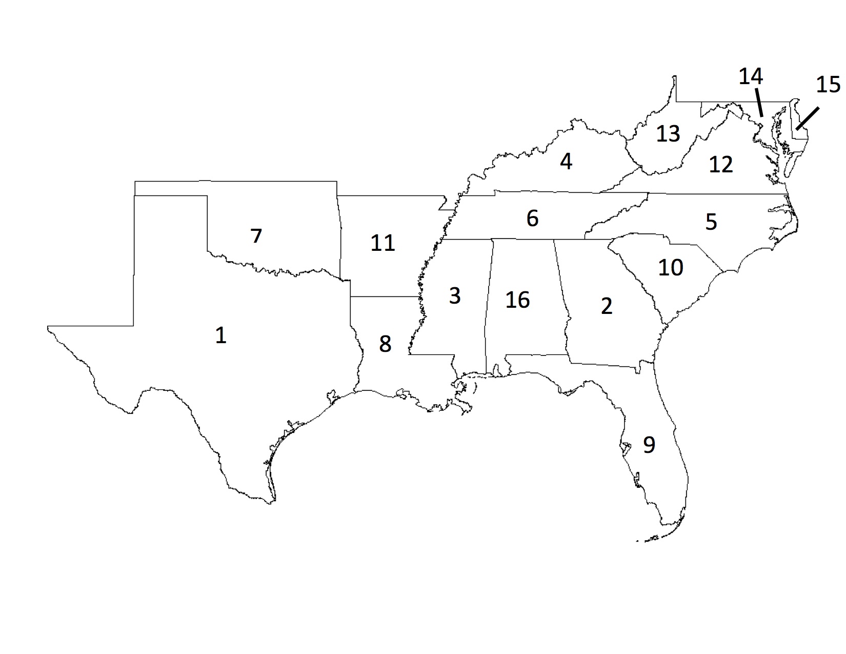
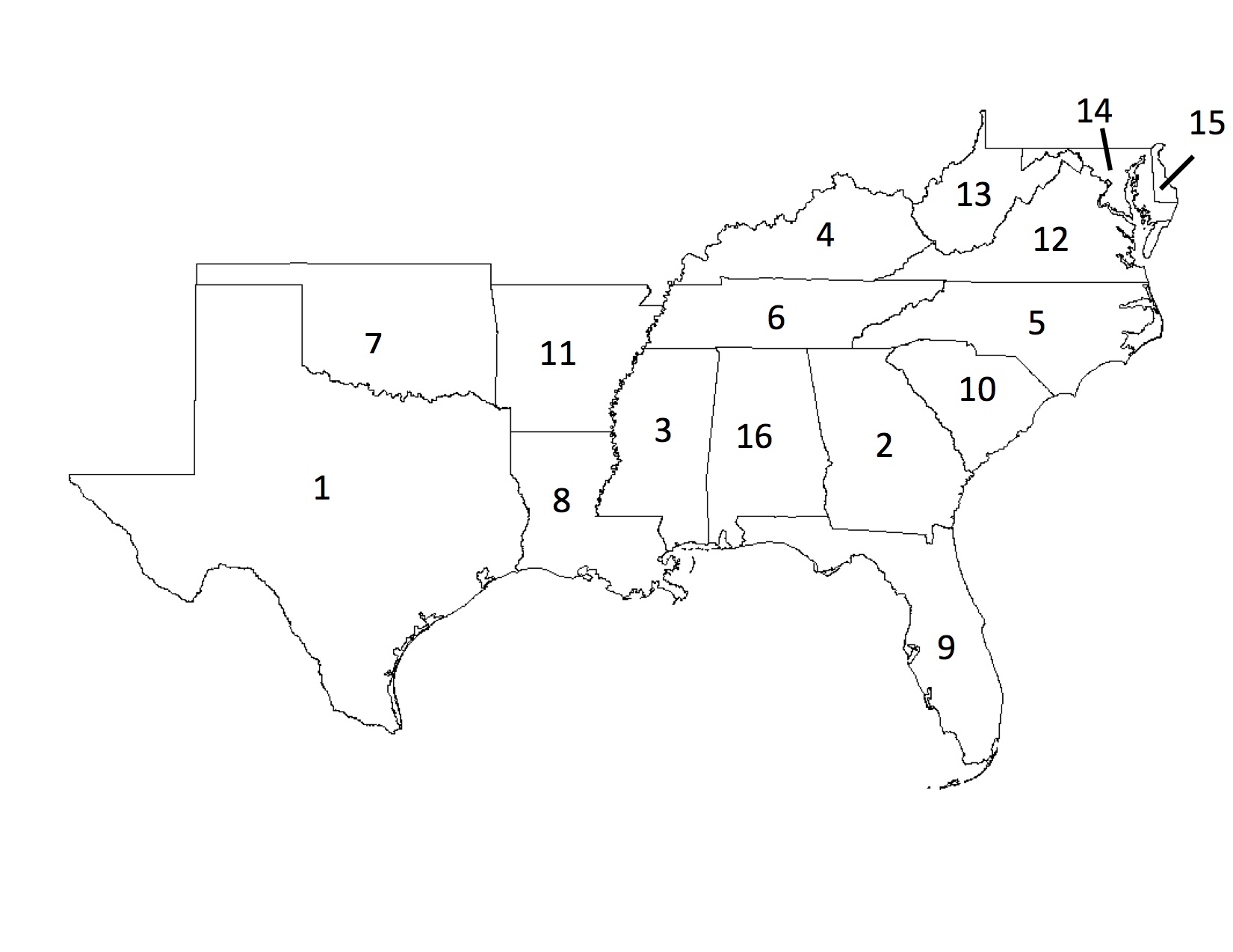
What state is #8
a)
Louisiana
b)
Mississippi
c)
Kentucky
d)
Alabama
26.
Canadian province # 9 is:
a)
Nunavut
b)
Ontario
c)
Quebec
27.
How many Canadian provinces border the United States?
a)
None
b)
5
c)
6
d)
7
28.
What country is # 8?
a)
Panama
b)
Belize
c)
Paraguay
d)
Costa Rica
29.
A vast mountain chain that runs from northern South America to southern South America along the west coast (letter D).
a)
The Himalaya Mountains
b)
Appalachian Mountains
c)
Rocky Mountains
d)
Andes Mountains
30.
This landform that connects Central America and South America is called a/an:
a)
bay
b)
isthmus
c)
cape
d)
glacier
31.
Canadian province # 2 is:
a)
British Columbia
b)
Ontario
c)
Yukon Territory
32.
Canadian province # 4 is:
a)
Alberta
b)
Saskatchewan
c)
Manitoba
33.
What country is # 1?
a)
Brazil
b)
Columbia
c)
Argentina
d)
Venezuela
34.
What country is # 2?
a)
Bolivia
b)
Peru
c)
Paraguay
d)
Argentina
35.
What country is # 5?
a)
Argentina
b)
Bolivia
c)
Colombia
d)
Chile
36.
What country is # 6?
a)
Chile
b)
Peru
c)
Argentina
d)
Brazil
37.
What country is # 7?
a)
Peru
b)
Bolivia
c)
Argentina
d)
Uruguay
38.
What country is # 9 ?
a)
Colombia
b)
Ecuador
c)
Venezuela
d)
Peru
39.
What island is east of the Dominican Republic?
a)
Puerto Rico
b)
Jamaica
c)
Dominican Republic
d)
Bahamas
40.
Which number is Asia?
a)
4
b)
6
c)
3
d)
7
41.
The Pacific Ocean is _____________. 
a)
3
b)
1
c)
4
d)
3
42.
What large mountain range is pictured here?
a)
Catskill Moutains
b)
Rocky Moutanins
c)
Appalachian Mountains
43.
These bodies of water are connected to each other and contain fresh water
a)
Great Lakes
b)
St. Lawrence River
c)
Gulf of Mexico
d)
Atlantic Ocean
44.
This body of water is located between Mexico and Florida.
a)
Erie Canal
b)
Continental Divide
c)
Gulf of Mexico
d)
St. Lawrence River
45.
Name the State #43
a)
Oklahoma
b)
Oregon
c)
Minesota 
d)
Idaho
46.
What state is #7
a)
Oklahoma
b)
Florida
c)
Texas
d)
Georgia
47.
What state is in red?
a)
New York
b)
Ohio
c)
Virginia
d)
Washington
48.
What state is in red?
a)
California
b)
Utah
c)
Connecticut
d)
Hawaii
49.
Which area of the map contains the Rocky Mountains?
a)
I
b)
II
c)
III
d)
IV
50.
What country is # 2?
a)
Guatemala
b)
Honduras
c)
Nicaragua
d)
Costa Rica
51.
What is the Absolute Location of Denver?
a)
west of St. Louis
b)
105 degrees W by 39 degrees N
c)
Southeast of Seattle
d)
39 degrees W by 105 degrees N
52.
The Arab Spring started in:
a)
2017
b)
2010
c)
1939
d)
2001
53.

Which number labels the country of Israel?

a)

12

b)

11

c)

7

d)

1

54.
Push factors include all of the following EXCEPT
a)
war
b)
famine
c)
disease
d)
education
55.
Name this Country 
a)
Paraguay
b)
Peru
c)
Guyana 
d)
Brazil 
56.
What are earthquakes, volcanoes and hurricanes all examples of when thinking about the essential elements?
a)
Physical Systems
b)
Movement
c)
Place
d)
GIS
57.
My house is right down the street from the Massanutten Water Park.  This is an example of _______________ location.
a)
geographic
b)
absolute
c)
topographic
d)
relative
58.
40.4406° N, 79.9959° W
describe the ______________ location of Pittsburgh, PA.
a)
Relative
b)
Absolute
c)
Regional
d)
Political
59.
What are the 3 major climate zones in order from equator to the poles?
a)

polar, middle, tropical

b)

tropical, middle, polar

c)

middle, polar, tropical

d)

middle, tropical, polar

60.
Building dams, plowing and irrigating fields, and digging mines are examples of...  
a)
depending
b)
adapting
c)
modifying
61.

Which of the following continents is shown in the image?

a)

North America

b)

Europe

c)

South America

d)

Africa

62.

Which of the following continents is shown in the image?

a)

South America

b)

Africa

c)

Europe

d)

Antarctica

63.

Use the map below to select the answer choice which correctly identifies the world's oceans.

a)

1.Atlantic / 2. Pacific / 3. Arctic / 4. Southern / 5. Indian

b)

1.Pacific / 2. Indian / 3. Arctic / 4. Southern / 5. Atlantic

c)

1.Pacific / 2. Atlantic / 3. Arctic / 4. Indian / 5. Southern

d)

1.Atlantic / 2. Indian / 3. Arctic / 4. Southern / 5. Pacific

64.
People who believe that the Jewish people deserve a homeland in Israel for religious reasons are called ________.
a)
Semites
b)
Zionists
c)
Arabs
d)
Jewish
65.

Anti-Semitism is...

a)

Prejudice or hatred towards Jews

b)

The belief in creating a nation state

c)

The traditional name of Palestine

d)

A type of propaganda

66.

What major historical event sparked the Zionist movement?

a)

WW1

b)

Korean War

c)

Cold War

d)

Holocaust

67.

What is the most likely religion of someone who lives in Israel?

a)

Jewish

b)

Christian

c)

Muslim

d)

All of the above

68.

What two bodies of water does the Panama Canal connect?

a)

Mediterranean Sea & Red Sea

b)

Atlantic Ocean & Pacific Ocean

c)

Atlantic Ocean & Indian Ocean

d)

Pacific Ocean & Arctic Ocean

69.
Why did the U.S build the Panama Canal?
a)
to reduce travel time
b)
to speed up trade
c)
to protect from invaders
d)
for fishing
70.
What is the importance of canals and why are they constructed?
a)
to make more water in the world
b)
to make it easier for people to go from one place to another
c)
to create a waterway connecting one ocean to another ocean and make travel time faster.