
 Worksheets
Oceans Summative Review
Total questions: 50
Worksheet time: 33mins
Name
Class
Date
1.

A long, underwater mountain chain
a)
salinity
b)
deep-ocean basin
c)
thermocline
d)
mid-ocean ridge
2.

A long, narrow underwater depression
a)
continental margin
b)
deep-ocean basin
c)
thermocline
d)
ocean trench
3.

What two properties affect the density of the ocean water?
a)
time of day and season
b)
latitude and depth
c)
salinity and temperature
d)
tides and position of the moon
4.
mountain ranges in the ocean
a)
mid -ocean ridge
b)
trenches
c)
rift
d)
ocean basin
5.
the deepest part of the ocean
a)
trenches
b)
abyssal plain
c)
ocean basin
d)
rift
6.
the deep flat land of the ocean floor
a)
abyssal plain
b)
rift
7.
Scientists use ______ to determine the oceans depth.
a)
Submarine
b)
Sonar
c)
Helicopter
d)
Light
8.
Which structure extends from the outer edge of the continental shelf to the ocean floor?
a)
continental
slope
b)
abyssal
plain
c)
oceanic
trench
d)
sea mount
9.

Label A
a)
continental slope
b)
continental shelf
c)
abyssal plain
d)
sea mount
10.

Label B
a)
continental slope
b)
continental shelf
c)
abyssal plain
d)
sea mount
11.

Label C
a)
continental slope
b)
continental shelf
c)
abyssal plain
d)
sea mount
12.

Label D
a)
continental slope
b)
continental shelf
c)
abyssal plain
d)
mid ocean ridge
13.

Label E
a)
continental slope
b)
volcanic island
c)
abyssal plain
d)
sea mount
14.

Label F
a)
continental slope
b)
continental shelf
c)
abyssal plain
d)
sea mount
15.
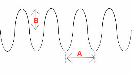
What property of this wave is represented by the letter "A"
a)
amplitude
b)
crest
c)
trough
d)
wavelength
16.
The highest point on a wave is:
a)
the crest
b)
the trough
c)
the top
d)
the coast
17.
The lowest point on a wave is the:
a)
Amplitude
b)
Crest
c)
Trough
d)
Wavelength
18.

Which vocabulary term is used to identify the distance between points C & G?
a)
Amplitude
b)
Crest
c)
Frequency
d)
Wavelength
19.
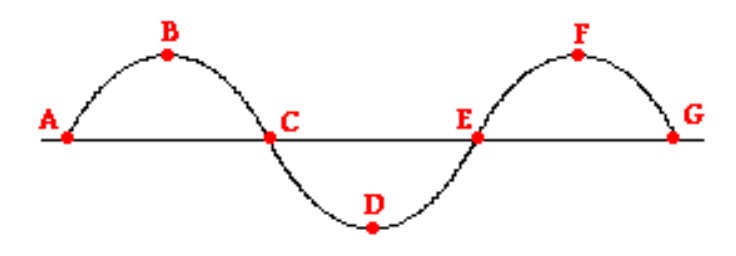
Which letter(s) represent the trough of the wave?
a)
A
b)
B & D
c)
D
d)
C & G
20.
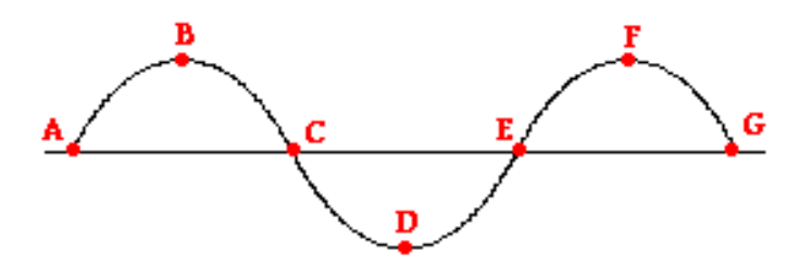
Which letter(s) represent the crest of the wave?
a)
A
b)
B & D
c)
B & F
d)
F
21.
crest to crest or trough to trough
a)
crest
b)
trough
c)
amplitude
d)
wavelength
22.
The Coriolis Effect is caused by
a)
Earth rotating around the sun
b)
Earth rotating on its axis
c)
The tides
d)
Gravity
23.
Surface currents are a result of
a)
Global Wind Patterns
b)
Earth's Rotation
c)
Density
d)
All of the above
24.
The Gulf stream carries _____________ water from the east coast of The United States to the West coast of Europe.
a)
Cold
b)
Warm
c)
Freezing
d)
Fresh
25.
Warm ocean currents generally come from
a)
The North Pole
b)
The South Pole
c)
The Equator
d)
Both A and B
26.
Cold ocean currents generally come from
a)
The North Pole
b)
The South Pole
c)
The Equator
d)
Both A and B
27.
Two types of water currents are
a)
local and global
b)
sea and land
c)
surface and deep
d)
warm and cold
28.
A horizontal movement of ocean water that is caused by wind and that occurs at or near the ocean's surface.
a)
Gulf Stream
b)
Global Conveyor Belt
c)
Surface Current
d)
Gyre
29.
What process brings the deep cold ocean currents up to the surface?
a)
Conduction
b)
Global Wind Patterns
c)
Upwelling
d)
Temperature and salinity
30.
Deep-ocean currents are driven by
a)
differences in soil
b)
differences in the water’s density,
c)
differences in nutrients
d)
None of the Above
31.
Cold ocean currents are most likely to be located at deeper ocean depths than warm water currents because
a)
A.Winds
push the cold water down.
b)
Ocean tides force cold water downward
c)
A.Cold
water is more dense and sinks
d)
A.Cold
water has less salt to help it freeze and sink.
32.

Warm ocean currents generally come from
a)
The North Pole
b)
The South Pole
c)
The Equator
d)
Both A and B
33.
What factors create deep ocean currents?
a)
Increase in salinity; increase in temperature
b)
Decrease in salinity; decrease in temperature
c)
Increase in salinity; decrease in temperature
d)
Decrease in salinity; increase in temperature
34.
A[n] ______________ tide occurs when the sun is at right angles to the line between Earth and the moon.
a)
high
b)
neap
c)
low
d)
spring
35.
Differences in the moon's and sun's pull on different sides of the Earth cause _________.
a)
gravity
b)
lunar phases
c)
tides
d)
dabbing
36.
A[n] ___________ tide occurs when the sun, Earth, and the moon are nearly in a line.
a)
spring
b)
high
c)
low
d)
neap
37.
The bulge of water on the side of the Earth closest to the moon produces ___________.
a)
high tide
b)
low tide
c)
neap tide
d)
spring tide
38.
A neap tide is a tide with the greatest difference between low and high tides
a)
true
b)
false
39.

Wha type of tide would this arrangement of earth-moon-sun create?
a)
full moon tide
b)
new moon tide
c)
neap tide
d)
spring tide
40.

Which body has the greater effect on Earth's tides?
a)
Sun
b)
Saturn
c)
Moon
d)
Venus
41.

What type of tides would this arrangement of earth-moon-sun create?
a)
neap tide
b)
spring tide
c)
new moon tide
d)
full moon tide
42.

Which phase of the moon is represented in this diagram?
a)
new moon
b)
first quarter
c)
full moon
d)
last quarter/third quarter
43.

Which moon phase is shown in this diagram?
a)
new moon
b)
first quarter
c)
full moon
d)
last quarter/3rd quarter
44.
How many low tides and high tides happen in a day?
a)
1 low tide, 1 high tide
b)
4 low tides, 4 high tides
c)
3 low tides, 3 high tides
d)
2 low tides, 2 high tides
45.
This zone extends from low-tide area out over the continental shelf.
a)
Open-Ocean Zone
b)
Intertidal Zone
c)
Neretic Zone
d)
Zone Defense
46.
The part of the ocean that extends from the low-tide line to the edge of the continental shelf is the
a)
Nertic Zone
b)
Open Ocean Zone
c)
Intertidal Zone
d)
Deep Zone
47.
a gently sloping, shallow area of the ocean floor that extends outward form the edge of the continent
a)
continental shelf
b)
continental slope
c)
abyssal plain
d)
mid-ocean ridge
48.
the region of shallow ocean water over the continental shelf
a)
Nertic Zone
b)
Open Ocean Zone
c)
Atoll
49.
This is the zone between high-tide and low-tide (literally means between tides)
a)
Twilight Zone
b)
Neretic Zone
c)
Open-ocean Zone
d)
Intertidal Zone
50.
This zone includes any area beyond the continental shelf where water is deepest.
a)
Open-Ocean Zone
b)
Neretic Zone
c)
Intertidal Zone
d)
Auto Zone
100 %

