
 Worksheets
UAG ES MP3 - Agents of Erosion, Hydrology, Soils Review
Total questions: 99
Worksheet time: 1hrs 16mins
Name
Class
Date
1.
What is the movement of soil from one place to another?
a)
weathering
b)
deposition
c)
discharge
d)
erosion
2.
The slow downhill movement of weathered rock material is called...
a)
mass movement
b)
abrasion
c)
sheet erosion
d)
creep
3.
Some lakes, such as the Great Lakes, formed in deep basins carved by ____.
a)
wind
b)
water
c)
glaciers
d)
moraines
4.
Land formed where a river enters the ocean
a)
delta
b)
gravity
c)
glacier
d)
mouth
5.
Place where a river flows into a large body of water
a)
moraine
b)
deposition
c)
mouth
d)
delta
6.
Dropping of eroded sediment
a)
deposition
b)
delta
c)
alluvial fan
d)
mouth
7.
The result of the oxidation of iron in rocks is ____.
a)
caves
b)
carbonic acid
c)
rust
d)
iron
8.
Landslides and tilting are forms of erosion caused by this
a)
moraine
b)
alluvial fan
c)
gravity
d)
delt
9.

Water getting into cracks, freezing, and breaking the rocks or pavement apart
a)
Weathering
b)
Erosion
c)
Deposition
10.

Wind blasting sand at rock and carving out caves
a)
Weathering
b)
Erosion
c)
Deposition
11.
Waves dropping sand on the beach
a)
Weathering
b)
Erosion
c)
Deposition
12.
Which is NOT an igneous rock?
a)
coal
b)
granite
c)
pumice
d)
obsidian
13.

What is mechanical weathering?
a)
Process through which rocks are physically broken into smaller pieces.
b)
Rocks are broken down through chemical changes.
c)
Rocks are worn away from acid in plant roots.
d)
Rocks broken down by machinery.
14.
Mechanical weathering breaks down existing rocks by
a)
Changing them chemically, but not physically.
b)
Changing them physically, but not chemically.
c)
Changing them chemically and physically.
d)
Incorporating them into new rocks.
15.
Tree roots cause
a)
physical weathering.
b)
chemical weathering.
c)
both chemical and physical weathering.
d)
neither chemical or physical weathering.
16.
Which of the following is an example of chemical weathering?
a)
Acid rain dissolving limestone
b)
roots breaking into concrete
c)
paper being ripped
d)
Water running over rocks
17.
What is a type of mass movement by gravity?
a)
dune
b)
loess
c)
glacier
d)
mudslide
18.
Which erosion agent is used to develop a creep?
a)
gravity
b)
glaciers
c)
oxidation
d)
wind
19.
How does a sinkhole form?
a)
Stalactites erode a ceiling of a cave
b)
Streams in mountains erode sediment
c)
Underground water forms a cave
d)
Stream erodes soil making it wider
20.

What type of erosion causes landslides
a)
wind
b)
waves
c)
water
d)
gravity
21.

Deltas are built up by -
a)
deposition
b)
leaching
c)
abrasion
d)
erosion
22.

What kind of weathering causes the mineral composition of rocks to change?
a)
mechanical weathering
b)
permeable weathering
c)
chemical weathering
d)
physical weathering
23.

A rock containing iron becomes soft and crumbly and reddish-brown in color. It probably has been chemically weathered by -
a)
abrasion
b)
carbon dioxide
c)
oxygen
d)
acid rain
24.
A hot wet climate causes weathering to take place -
a)
slowly
b)
rapidly
c)
unevenly
d)
at the same rate as when the climate is dry and cool
25.
Many barrier islands such as the Outer Banks in North Carolina have developed from wave action and deposition.
a)
True
b)
False
26.
The most important factors in determining the rate of weathering are -
a)
carbon dioxide and acid rain
b)
abrasion and acids from plant roots
c)
animal actions and oxygen
d)
rock type and climate
27.
When wind, water, or ice leave materials in a location, this is known as:
a)
Weathering
b)
Erosion
c)
Deposition
d)
Transportation
28.
wind erosion forms what type of landform?
a)
meander
b)
drumlin
c)
sand dune
d)
sand bar
29.
Landscapes characterized by gentle slopes and meandering streams are most often found in regions with
a)
steep mountain cliffs
b)
sediment-covered bedrock
c)
recently active faults and folds
d)
high volcanic activity
30.
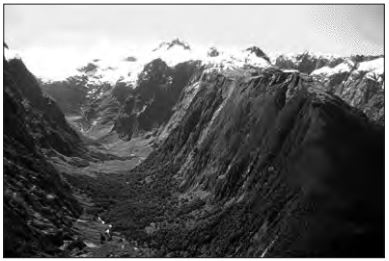
The photograph below shows a valley. Which agent of erosion most likely produced this valley’s shape?
a)
blowing wind
b)
ocean waves
c)
moving ice
d)
running water
31.
Pieces of bedrock material that are broken from a cliff and deposited by a landslide at the base of the cliff are best described as
a)
rounded and sorted
b)
rounded and unsorted
c)
angular and sorted
d)
angular and unsorted
32.
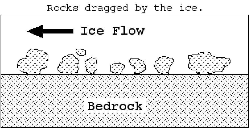
_____ is rock debris embedded in base of ice create polishing, grooves and striations.
a)
Plucking
b)
Abrasion
c)
Weathering
d)
Erosion
33.
A _____ is a mass of ice that moves downhill due to its weight.
a)
glacier
b)
erratic
c)
fjiord
d)
moraine
34.
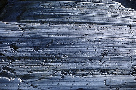
_____ are parallel scratch marks on bedrock
a)
Plucking
b)
Abrasion
c)
Straitions
d)
Till
35.
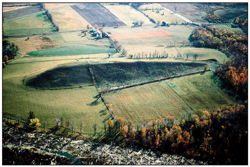
A _____ is a tear-drop-shaped hill created by ice flow over and around till deposit.
a)
drumlin
b)
esker
c)
moraine
d)
erratic
36.
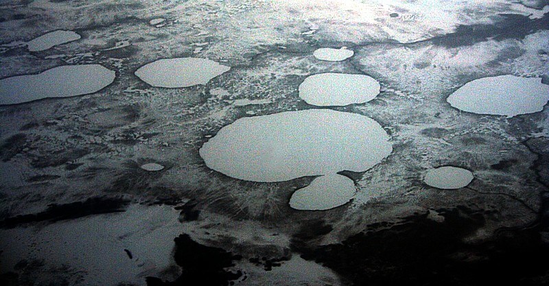
A _____ are depressions formed as stranded ice blocks melt in outwash.
a)
erratics
b)
eskers
c)
kettles
d)
drumlin
37.
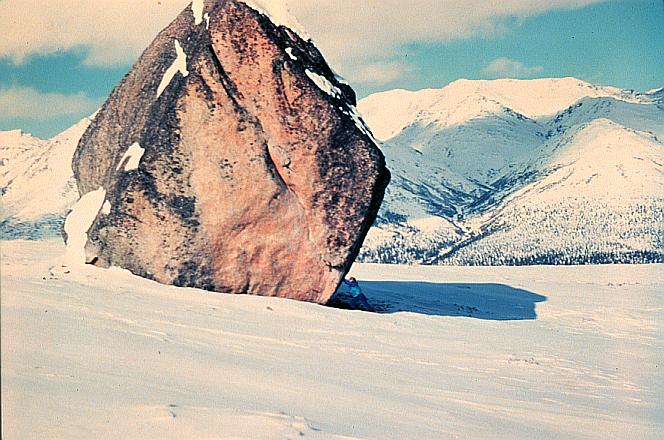
_____ are enormous boulders transported and deposited by glaciers, often far from their source region.
a)
Till
b)
Erratics
c)
Moraines
d)
Fjords
38.
Which New York State landscape region is mostly composed of horizontal sedimentary bedrock at high elevations?
a)
Hudson Highlands
b)
Allegheny Plateau
c)
Taconic Mountains
d)
Atlantic Coastal Plain
39.
The Catskills of New York State are best described as a plateau, while the Adirondacks are best described as mountains. Which factor is responsible for the difference in landscape classification of these two regions?
a)
climate variations
b)
bedrock structure
c)
vegetation type
d)
bedrock age
40.
Which type of climate has the greatest amount of rock weathering caused by frost action?
a)
a wet climate in which temperatures remain below freezing
b)
a wet climate in which temperatures alternate from below freezing to above freezing
c)
a dry climate in which temperatures remain below freezing
d)
a dry climate in which temperatures alternate from below freezing to above freezing
41.
If a stream is carrying sand, large boulders, clay and small pebbles, which type of particle is deposited last as the stream begins to slow down?
a)
Clay
b)
Sand
c)
Large boulders
d)
Small pebbles
42.

In this cross section of a stream, where is the fastest current located?
a)
A
b)
B
c)
C
d)
D
43.

How did this terrain feature form?
a)
A meander of a stream that has been cut off
b)
A glacier that scoured out the land
c)
The result of a floor
d)
None of the above
44.
fan-shaped deposit at the mouth of a stream
a)
Delta
b)
Oxbow
c)
Point Bar
d)
Headwater
45.
an alluvial deposit that forms by accretion on the inner side of an expanding loop of a river.
a)
Point Bar
b)
Cutbank
c)
Oxbow
d)
Headwater
46.

What is the winding part of a river?
a)
Canyon Building River
b)
Downcutting River
c)
Meandering River
d)
Winding River
47.

What is #3?
a)
Delta
b)
riverbank
c)
source
d)
mouth
48.

What is a delta?
a)
Area of water
b)
fan shaped mass of material deposited at the mouth of a stream
c)
slope of land
d)
sediments deposited at a river
49.
Where do the ends of most rivers go ?
a)
Deserts
b)
Mountains
c)
Lakes
d)
Oceans
50.

What is it called when plants give off water vapor as a waste product?
a)
condensation
b)
evaporation
c)
sublimation
d)
transpiration
51.
Snow, sleet, hail, and rain are all examples of ________________.
a)
evaporation
b)
condensation
c)
accumulation
d)
precipitation
52.
Which of these is an example of precipitation?
a)
snow
b)
air
c)
clouds
d)
vapor
53.

What part of the water cycle does this picture show?
a)
condensation
b)
precipitation
c)
evaporation
54.
In a river, where does the current move the fastest?
a)
In the outer bend of a curve
b)
In the inner bend of a curve
c)
Near the edges of a straight part
d)
In the middle of a straight part
55.
Why do currents in the northern and southern hemisphere move opposite to one another?
a)
because of density
b)
because of temperature
c)
Coriolis Effect
d)
Storms
56.
When water, ice, or snow falls from clouds to the earth, that is
a)
evaporation
b)
condensation
c)
transpiration
d)
precipitation
57.
When water in the leaves of plants becomes water vapor in the atmosphere, that is called
a)
condensation
b)
evaporation
c)
precipitation
d)
transpiration
58.

The triangular deposition of sediment that forms where a stream/river enters a large body of water, such as a lake or ocean, is called
a)
Alluvial fan
b)
Delta
c)
Flood plain
d)
Meander
59.
Which of the following would have the highest porosity?
a)
Bedrock
b)
Crushed stone
c)
Sand
d)
Clay
60.

What process is happening at C in the diagram?
a)
runoff
b)
precipitation
c)
condensation
d)
transpiration
61.
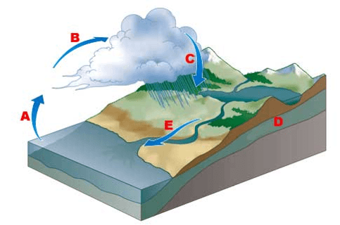
What is occurring at A in the diagram?
a)
runoff
b)
precipitation
c)
evaporation
d)
condensation
62.
Porosity refers to...
a)
the shape of the particles
b)
The sorting of the particles
c)
% of pore space in a material
d)
% of cement in a material
63.
Impermeable materials...
a)
have an abundance of pores.
b)
let water in.
c)
have little to no pores.
64.

Poorly sorted soil...
a)
has low porosity
b)
has high porosity
c)
has high pore space
d)
means water will move through quickly
65.

Well sorted soil...
a)
has low porosity
b)
has low pore space
c)
has high porosity
d)
means water will move through slowly
66.

Which graph shows the effect of soil permeability on the amount of runoff in an area?
a)
1
b)
2
c)
3
d)
4
67.
A soil sample with a large amount of space between the particles will have a
a)
High Porosity
b)
Low permeability rate
c)
High capillarity
d)
Low infiltration rate
68.
Flash flooding often occurs in city areas because
a)
Roads, pavements, and buildings reduce the infiltration of water into the ground
b)
Ground water storage is usually very large
c)
unoff decreases during precipitation
d)
The heat generated by city areas decreases actual evapotranspiration
69.

Base your answer to the following question on the diagram, which represents samples of soil and bedrock at Earth’s surface. The arrows represent possible infiltration of rainwater Which sample probably has the greatest porosity?
a)
Granite bedrock
b)
Pebble-and-sand soil
c)
Pebble soil
d)
Conglomerate bedrock
70.
The direct cause of ground water supplies becoming unfit for human use is usually
a)
An uncontrollable deficit
b)
Excessive surface runoff and flooding
c)
Very heavy precipitation
d)
Contamination of the saturated zone by pollutants
71.

The diagram shows two identical containers filled with uniform particles that were sorted by size. Which characteristic is most likely the same for these particle-filled containers?
a)
Water retention
b)
Capillarity
c)
Infiltration rate
d)
Porosity
72.

The diagram represents three containers, A, B, and C, which were filled with equal volumes of uniformly sorted plastic beads. Water was poured into each container to determine porosity and infiltration time. See picture for question
a)
1
b)
2
c)
3
d)
4
73.
Which soil conditions normally result in the greatest amount of runoff? Question*
a)
vegetation and steep slope
b)
no vegetation and steep slope
c)
vegetation and gentle slope
d)
no vegetation and gentle slope
74.
Which sediment size would allow water to flow through at the fastest rate?
a)
Sand
b)
Clay
c)
Silt
d)
Pebbles
75.
During a rainfall, surface runoff will probably be greatest in an area that has a
a)
Steep slope and a clay-covered surface
b)
Steep slope and a gravel-covered surface
c)
Gentle slope and a grass-covered surface
d)
Gentle slope and a tree-covered surface
76.
Water can pass through a sandstone sample because the sample is
a)
Permeable
b)
Well compacted and cemented
c)
Organic in origin
d)
Composed of pebble-sized particles
77.
Which set of surface soil conditions on a hillside would result in the most infiltration of rainfall?
a)
Steep slope, unsaturated soil, no vegetation
b)
Gentle slope, unsaturated soil, vegetation
c)
Steep slope, saturated soil, vegetation
d)
Gentle slope, saturated soil, no vegetation
78.
Compared to an area of Earth’s surface with gentle slopes, and area with steeper slopes most likely has
a)
More infiltration and more runoff
b)
Less infiltration and more runoff
c)
More infiltration and less runoff
d)
Less infiltration and less runoff
79.

The diagram is a cross-sectional view of rain falling on a farm field and then moving to the water table Which word best describes the movement of the rainwater through zone A?
a)
Saturation
b)
Runoff
c)
Precipitation
d)
Infiltration
80.
What size particle has the greatest rate of infiltration
a)
small
b)
medium
c)
large
d)
size doesn't affect this
81.
What size particle has the greatest permeability
a)
small
b)
medium
c)
large
d)
size doesn't affect this
82.
Which trait would result in high rates of runoff
a)
gentle slope
b)
high saturation of ground
c)
high porosity
d)
high permeability
83.
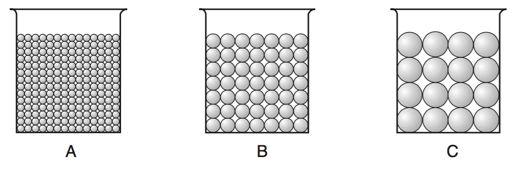
The cross sections below represent three beakers that were used to test porosity. Beakers A, B, and C each contain a different size of bead. Each beaker holds an equal volume of beads. The amount of water needed to fill the total pore space between the beads in each beaker was measured.
Which statement best describes the porosity that was found for these three samples?
Which statement best describes the porosity that was found for these three samples?
a)
A had a greater porosity than B and C.
b)
B had a greater porosity than A and C.
c)
C had a greater porosity than A and B.
d)
All three samples had the same porosity.
84.
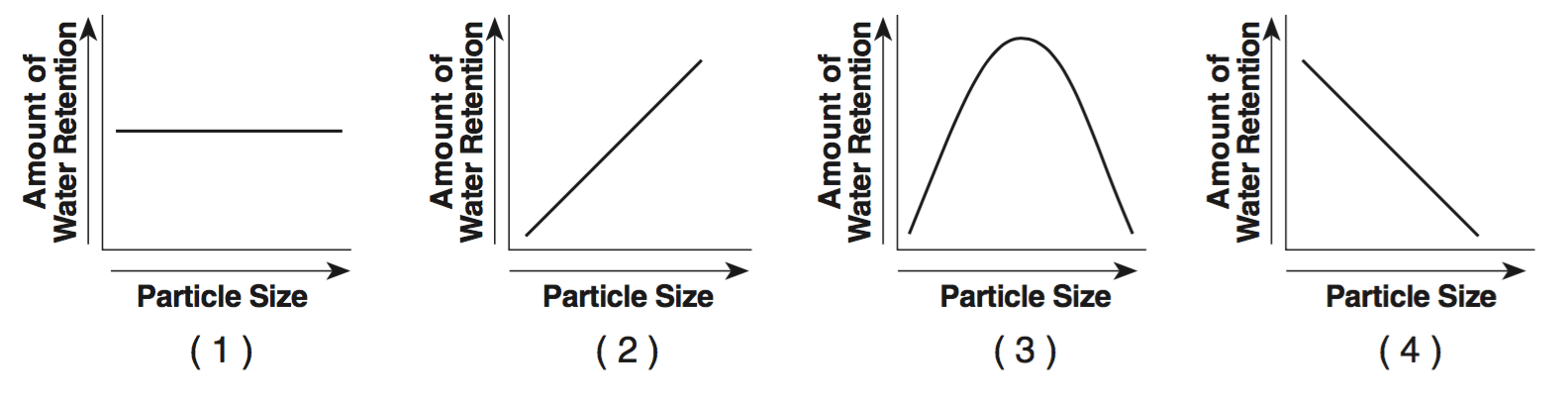
Which graph best indicates the general relationship between soil particle size and the amount of water retention by a permeable soil?
a)
GRAPH 1
b)
GRAPH 2
c)
GRAPH 3
d)
GRAPH 4
85.
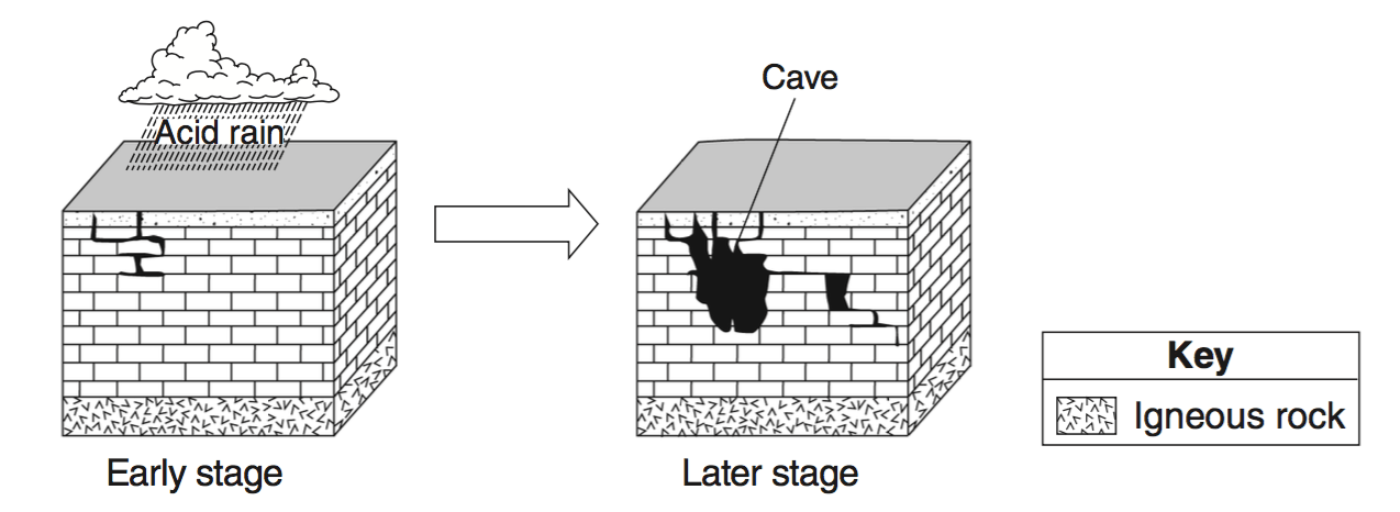
The two block diagrams below represent the formation of caves.
Which types of weathering and erosion are primarily responsible for the formation of caves?
Which types of weathering and erosion are primarily responsible for the formation of caves?
a)
chemical weathering and groundwater flow
b)
chemical weathering and runoff
c)
physical weathering and groundwater flow
d)
physical weathering and runoff
86.

Which diagram represents a side view of a sand dune most commonly formed as a result of the prevailing wind direction shown?
a)
DIAGRAM 1
b)
DIAGRAM 2
c)
DIAGRAM 3
d)
DIAGRAM 4
87.

Which diagram represents the soil with the greatest permeability?
a)
Choice 1
b)
Choice 2
c)
Choice 3
d)
Choice 4
88.
Sand sediments are usually more permeable than silt sediments because sand grains are...
a)
larger
b)
smoother
c)
rounder
d)
more soluble
89.
Soil with the greatest porosity has particles that are...
a)
poorly sorted and densely packed
b)
poorly sorted and loosely packed
c)
well sorted and densely packed
d)
well sorted and loosely packed
90.

Which graph shows the effect of soil permeability on the amount of runoff in an area?
a)
Choice 1
b)
Choice 2
c)
Choice 3
d)
Choice 4
91.
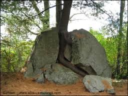
How do plants weather rocks?
a)
During photosynthesis
b)
When roots grow into cracks of rocks and expand the rock breaks.
c)
When the plant moves water from the roots to the leaves, the rock breaks.
d)
Plants don't weather rocks.
92.

Water can infiltrate loose soil when the soil is...
a)
saturated and permeable
b)
saturated and impermeable
c)
unsaturated and permeable
d)
unsaturated and impermeable
93.
The process by which water, ice, wind or gravity moves weathered rock and soil from one place to another.
a)
weathering
b)
erosion
c)
deposition
d)
dumptruck
94.
This type of weathering occurs when rock is physically broken down into smaller pieces of rock.
a)
mechanical weathering
b)
chemical weathering
c)
erosion weathering
d)
deposition
95.

Beaches are built up by -
a)
deposition
b)
leaching
c)
abrasion
d)
erosion
96.
In wet environments, the major cause of erosion is:
a)
wind
b)
animal movement
c)
moving water
d)
air movement
97.

These rocks were made smooth by wind blowing smaller rock particles across their surface. This is an example of:
a)
ice wedging
b)
chemical weathering
c)
acid rain
d)
abrasion
98.
All of the following are causes of physical weathering except...
a)
plant growth
b)
wind
c)
acid rain
d)
running water
99.
If water cannot pass through a material easily then the material is considered what?
a)
permeable
b)
artesian well
c)
unsaturated zone
d)
impermeable
100 %

