

wayground logo

Free Printable Worksheets

NEW

Font size

S
M
L
XL
Worksheets

EES-EHH - Test (Tectonic, Weather, Oceans)

Total questions: 50

Worksheet time: 33mins

Name
Class
Date
1.

What are the 2 types of ocean currents?

a)

surface & deep

b)

surface & shallow

c)

deep & far

d)

deep and near

2.

What is do we call a diverse and complex ecologic community of plants & animals which exist and thrive around the world?

a)

density

b)

gyres

c)

biome

d)

deltra

3.
What is the correct order (starting from the surface) of Earth's layers?
a)
crust, outer core, inner core, mantle
b)
mantle, outer core, inner core, crust
c)
crust, mantle, outer core, inner core
d)
outer core, inner core, crust, mantle
4.

Name the type of plate boundary in the following diagram

a)

transform

b)

divergent

c)

convergent (collision)

d)

subduction

5.

The force that causes the upward and downward movements of molten material that forms new continents

a)

continental drift

b)

sea floor spreading

c)

magnetic poles

d)

convection current

6.

Most earthquakes occur along or near the edges of the

a)

North American plate

b)

Earth’s oceans and lakes

c)

Eurasian plate

d)

Oceanic and Continental plates

7.

In which major earthquake zone are earthquakes produced mainly by plates moving away from each other

a)

the Pacific Ring of Fire

b)

the Mid-Atlantic Ridge

c)

the San Andreas Fault area

d)

the Eurasian-Melanesian mountain belt

8.

The most damaging earthquake wave

a)

S-wave

b)

P-wave

c)

Surface wave

d)

All the above

9.

The type of earthquake wave that travels the fastest and is the first to arrive at seismic

a)

P-wave

b)

S-wave

c)

L-wave

d)

Surface wave

10.

Plants piling up to form coal millions of years ago is an example of formation of a ____________ sedimentary rock.

a)

foliated

b)

chemical

c)

clastic

d)

biological/bituminous

11.

Type of rock formed whenever lava cools

a)

igneous

b)

lava

c)

metamorphic

d)

magma

12.

What is the minimum number of seismic recording stations needed in order to locate the epicenter of an earthquake

a)

6

b)

1

c)

2

d)

3

13.

A device or machine that measures the magnitude of an earthquake

a)

Richter scale or Mercalli scale

b)

seismic machine

c)

seismograph

d)

richtograph

14.

What rock type undergoes a change like a butterfly?

a)

Igneous

b)

Metamorphic

c)

Sedimentary

15.

What is a long narrow island lying parallel and close to the mainland, it protects the mainland from erosion and storms.

a)

fall zone

b)

river basin

c)

barrier island

16.

The process that occurs when physical forces break rock into smaller pieces without changing the rock’s chemical composition is called _________

a)

Differential weathering

b)

Chemical weathering

c)

Mechanical weathering

d)

Erosion

17.

What is the mountain range called in North Carolina?

a)

Appalachian Mountains

b)

Blue Ridge Mountains

c)

Rocky Mountains

18.

What part of another continent was stolen during a continental collision that formed North America and the Appalachian Mountains and now makes up part of the Eastern portion of North Carolina?

a)

Africa

b)

South America

c)

Australia

d)

We do not have any other continents attached to NC
19.
The natural chemical or physical processes that breaks down rock on Earth's surface.
a)
weathering
b)
erosion
c)
deposition
d)
jackhammering
20.
What is a watershed?
a)
Water in an area
b)
Water that flows into a river or stream
c)
Land that water flows over and through
d)
Water that is salty
21.
What is it called when smaller streams join together to make a larger river?
a)
Tributaries
b)
Topography
c)
Watershed
d)
Groundwater
22.
Where would you find brackish water?
a)
Wetlands
b)
Aquifers
c)
Glaciers
d)
Estuaries
23.
Brackish water is:
a)
Salty
b)
Fresh
c)
Found only in extremely cold water
d)
A mix of salty and fresh
24.
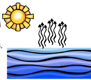
What part of the water cycle does this picture show?
a)
condensation
b)
precipitation
c)
evaporation
25.
When water condenses, the liquid water forms ______________.
a)
water vapor
b)
steam
c)
air
d)
clouds
26.
Which of these is an example of precipitation?
a)
snow
b)
air
c)
clouds
d)
vapor
27.
Where is most water found on Earth?
a)
glaciers
b)
lakes
c)
rivers
d)
oceans
28.
Does the water cycle ever end?
a)
Yes, once water evaporates it is gone forever
b)
Yes, when it rains, the water goes into the ground forever
c)
No, once it evaporates the water fairies come and sing a rainy day song.
d)
No, the water cycle has been going on for billions of years, and will continue on forever.
29.
What follows evaporation during the water cycle?
a)
Water evaporates into water vapor
b)
Water vapor condenses and forms a  cloud
c)
Water precipitates to the ground
d)
Water runs down into the hydrosphere
30.

What do we call a body of water found underground that is sitting in between the rocks?

a)

Watershed

b)

Water table

c)

Aquifer

d)

Groundwater

31.

Which of the following terms describes how water passes through/in between the rocks in the ground?

a)

Porous

b)

Percolate

c)

Aquifer

d)

Runoff

32.

Most pollution occurs when rainwater carries pollutants across the ground into a river, stream, lake, or ocean. Which of the following terms does this describe?

a)

Tributary

b)

Runoff

c)

Water table

d)

Permeable

33.

If you were going to dig a well to get water, through which level would you level would you have to dig through to get any water?

a)

Surface water

b)

Water table

c)

Recharge zone

d)

Pores

34.
Land containing much  soil moisture
a)
swamp
b)
wetland
c)
bog
d)
marsh
35.
wet, spongy land, partially or completely covered by water, with shrubs and trees
a)
wetland
b)
bog
c)
swamp
d)
marsh
36.
wet, spongy ground, poorly drained acidic soil, standing water, sphagnum peat moss
a)
bog
b)
marsh
c)
swamp
d)
wetland
37.
area of soft, wet land usually overgrown with grass
a)
swamp
b)
wetland
c)
bog
d)
marsh
38.
spring that throws forth hot water and steam
a)
harbor
b)
estuary
c)
bog
d)
geyser
39.
Which best explains what happens to nutrients in the ocean as a result
of upwelling?
a)
Upwelling carries nutrients to coral reefs.
b)
Upwelling carries nutrients to the ocean bottom.
c)
Upwelling carries nutrients to the intertidal zone.
d)
Upwelling carries nutrients to the surface of the ocean.
40.

El Nino is characterized by ___ water temperatures in the Pacific Ocean & the Equator.

a)

warm

b)

cool

c)

normal

41.
La Nina is characterized by ___ water temperatures in the Pacific Ocean.
a)
warm
b)
cool
c)
normal
42.
Which describes the hydrosphere?
a)
all of Earth’s organisms and the environments in which they live
b)
a layer of Earth’s atmosphere made up primarily of concentrated ozone
c)
all of the water in Earth’s oceans, lakes, seas, rivers, and glaciers, plus the water in the atmosphere
d)
the rigid outer part of the earth, consisting of the crust and upper mantle.
43.
Planetary orbits follow what shape?
a)
Perfect Circles
b)
Squares
c)
Ellipses
d)
Triangles
44.
What is the epicenter of an earthquake
a)
the location along a fault where the first motion of an earthquake occurs
b)
a seismic wave tht travels along the surface of Earth
c)
the point on Earth's surface directly above the earthquake's focus
d)
the last place that motion in an earthquake is detected
45.
This land form can occur at a divergent plate boundary.
a)
trench
b)
mid-ocean ridge
c)
folded mountains
d)
fault
46.
What drives tectonic plate movement? 
a)
gravity
b)
coriolis effect
c)
convection currents
d)
the earth's magnetic core
47.
The Moon causes Earth's tilt to wobble every 18 years.  This is called...
a)
precession
b)
nutation
c)
barycenter
d)
rotational axis
48.
Rock that forms when pressure, temperature, or chemical processes change existing rock.
a)
Igneous Rock
b)
Sedimentary Rock
c)
Metamorphic Rock
d)
Rock Cycle
49.
When water freezes, it expands and can cause rocks to fracture.  This is known as...
a)
Chemical weathering
b)
Physical weathering
c)
Erosion
d)
Chemical erosion
50.
This famous transform fault is located in the western United States creates significant earthquake activity for California
a)
Sierra Nevada Seismic Zone
b)
Denali Fault
c)
San Fransisco 
d)
San Andreas
