wayground logo

Free Printable Worksheets

Font size

S
M
L
XL
Worksheets

WEDGGL

Total questions: 136

Worksheet time: 2hrs 46mins
Name
Class
Date
1.
The natural chemical or physical processes that breaks down rock on Earth's surface.
a)
weathering
b)
erosion
c)
deposition
d)
jackhammering
2.
The process by which water, ice, wind or gravity moves weathered rock and soil from one place to another.
a)
weathering
b)
erosion
c)
deposition
d)
dumptruck
3.
This type of weathering occurs when rock is physically broken down into smaller pieces of rock.
a)
mechanical weathering
b)
chemical weathering
c)
erosion weathering
d)
deposition
4.
This type of weathering occurs when rocks weaken then break down due to chemical changes in the composition of the rock.
a)
mechanical weathering
b)
chemical weathering
c)
erosion weathering
d)
deposition
5.
These rocks were made smooth by wind blowing smaller rock particles across their surface.  This is an example of:
a)
ice wedging
b)
chemical weathering
c)
acid rain
d)
abrasion
6.
These rocks were broken apart from the continuous freeze/thaw of water in the cracks of the rocks. This is an example of:
a)
ice wedging
b)
acid rain
c)
permeability
d)
abrasion
7.
This rock may chemically weather easily because is has many spaces or holes in it that allow water to seep through it, meaning it is:
a)
permeable
b)
abrasive
c)
erosion
d)
unchangable
8.
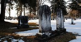
These gravestones have slowly broken down and turned a blackish color due to the action of:
a)
ice wedging
b)
abrasion
c)
acid rain
d)
mechanical weathering
9.
How might a weathered mountain appear different than an unweathered mountain?
a)
Weathered mountain would be taller.
b)
Weathered mountain would be rounder and less jagged.
c)
Weathered mountain would be more jagged and less rounded.
d)
Weathered mountain would have no trees.
10.
Weeds growing into the cracks in a sidewalk and the sidewalk begins to crumble is an example of:
a)
mechanical weathering
b)
chemical weathering
11.
Potholes forming in the road after a cold winter is an example of:
a)
mechanical weathering
b)
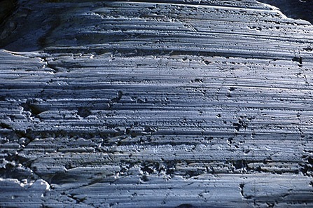
chemical weathering
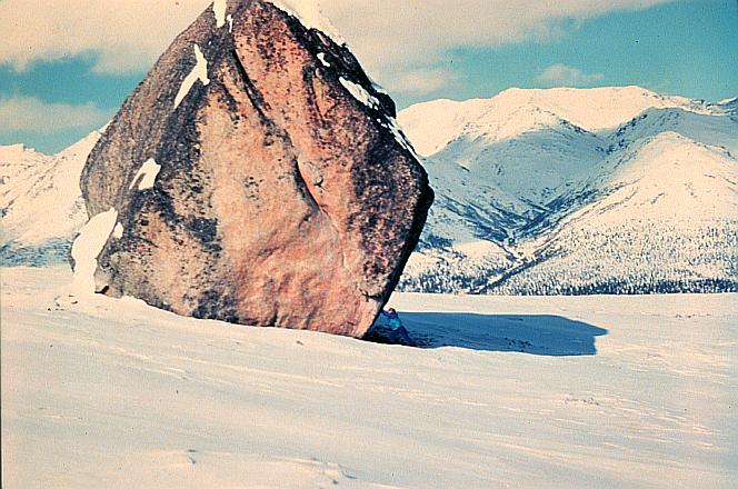
12.
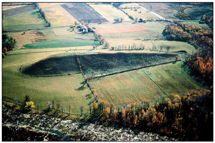
A metal statue slowly turning green after years of being outside is an example of:
a)
mechanical weathering
b)
chemical weathering
13.
Rocks along a riverbed that are smoothed from continuously moving water and sediment rubbing against them is an example of:
a)
mechanical weathering
b)
chemical weathering
14.
A piece of sandstone changing color (from brown to rusty red) from exposure to water and air is an example of:
a)
mechanical weathering
b)
chemical weathering
15.
The formation of stalactites and stalagmites in a cave as water mixed with carbon dioxide creates carbonic acid, which dissolves away the limestone, is an example of:
a)
mechanical weathering
b)
chemical weathering
16.
Exposure to rain and oxygen causes the metal minerals in rocks to rust and fall apart.  This is an example of:
a)
mechanical weathering
b)
chemical weathering
17.
Lichens (small green plants) growing on a large boulder release enzymes and other acids that slowly break the rock apart. This is an example of:
a)
mechanical weathering
b)
chemical weathering
18.
Select the answer that shows the order of events a rock goes through.
a)
erosion, weathering, deposition
b)
weathering, erosion, deposition
c)
deposition, weathering erosion
d)
erosion, deposition, weathering
19.
Sarah does the investigation described below using a model to study how rivers erode earth materials.
·  She pours 600 mL of sand onto a plate.
·  She pours 150 mL of water onto the pile of sand.
·  She measures how much of the sand washes off the edge of the plate.
·  She notices that less sand washes off the plate when she pours water slowly than when she pours it faster.
How is the model similar to real rivers eroding earth materials?
a)
The model shows that faster-moving water makes sand stick to the bottom of a river.
b)
The model shows that slower-moving water makes sand float to the top of a river.
c)
The model shows that slower-moving water erodes less earth materials than faster-moving water.
d)
The model shows that faster-moving water erodes less earth materials than slower-moving water.
20.
What has the greatest erosion effect on our beaches?
a)
waves
b)
gravity
c)
glaciers
d)
wind
21.

Which particles will be transported by a stream moving at a velocity of 5 cm/s?

a)

pebbles, sand, silt, and clay, only

b)

sand, silt, and clay, only

c)

silt and clay, only

d)

clay, only

22.

The Genesee River flows across both the Allegheny Plateau and the Erie-Ontario Lowlands in New York State. This river flows

a)

northward, in the same general direction as the Hudson River

b)

northward, in the same general direction as the Niagara River
c)

southward, in the same general direction as the Hudson River

d)

southward, in the same general direction as the Niagara River

23.

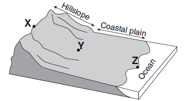
Compared to the stream velocity between point X and point Y, the stream velocity between point Y and point Z is most likely

a)

greater, since the slope of the land decreases

b)

greater, since the slope of the land increases

c)

less, since the slope of the land decreases

d)

less, since the slope of the land decreases

24.

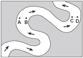
Erosion is most likely greatest at locations

a)

A and B

b)

B and C

c)

C and D

d)

D and A

25.

A river's current carries sediments into the ocean. Which sediment size will most likely be deposited in deeper water farthest from the shore?

a)

pebble

b)

sand

c)

slit

d)

clay

26.

Sediment is deposited in a river delta because the

a)

velocity of the river decreases

b)

force of gravity decreases

c)

volume of the river increases

d)

gradient of the river increases

27.

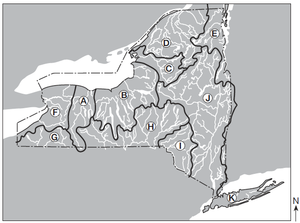
Over which two landscape regions do the streams in watershed D flow?

a)

Tug Hill Plateau and the Catskills

b)

Tug Hill Plateau and Erie-Ontario Lowlands

c)

Adirondack Mountains and Champlain Lowlands

d)

Adirondack Mountains and St. Lawrence Lowlands

28.

The Genesee River in watershed A generally flows in which direction?

a)

north

b)

south

c)

east

d)

west

29.

In which major watershed is the Susquehanna River located?

a)

F

b)

H

c)

I

d)

J

30.

Which two locations have the greatest stream velocities?

a)

A and B

b)

B and C

c)

C and D

d)

D and A

31.

The three areas separated by highland divides are called

a)

Tributaries

b)

meanders

c)

watersheds

d)

floodplains

32.

Which landform is produced at location E where the Mississippi River enters the Gulf of Mexico?

a)

delta

b)

drumlin

c)

tributary

d)

floodplain

33.

At which location would the Mississippi River's discharge most likely be the greatest?

a)

A

b)

B

c)

C

d)

D

34.

The map below shows an overhead view of sediments that have accumulated at the bottom of a lake. Points A through D represent locations on the shoreline of the lake. A river most likely flows into the lake nearest to location

a)

A

b)

B

c)

C

d)

D

35.

Which two cities are located in the Interior Lowlands?

a)

Elmira and Binghamton

b)

Riverhead and New York City

c)

Massena and Old Forge

d)

Buffalo and Watertown

36.
Which of the following best describes how erosion by groundwater might create a landform?
a)
Acidic water dissolves rock to form a cave
b)
Stream slowly wears away rock and soil
c)
Waves crashing against a shoreline
d)
Sediment building up to form a delta
37.
Sediment deposited as fast-flowing river reaches a flatter area of land is
a)
river dleta
b)
floodplain
c)
alluvial fan
d)
oxbow lake
38.
When would a river form a delta?
a)
when the river meanders across a plain
b)
when the river leaves the mountains
c)
when it is in the mountain
d)
when it enters the ocean
39.
What is groundwater?
a)
any form of liquid water
b)
water that is not moving
c)
water on Earth's surface
d)
water below Earth's surface
40.
What would be expected to remove the most sand from a barrier island during a storm?
a)
waves depositing debris on a island
b)
currents moving sand along the island
c)
large waves crashing across the island
d)
strong winds blowing across the island
41.
Which landform is formed because of the erosion of groundwater?
a)
valley
b)
canyon
c)
channel
d)
cavern
42.
What force is responsible for erosion and deposition in landslides?
a)
gravity
b)
ice
c)
wind
d)
temperature
43.
How does a glacier form?
a)
It must be below freezing & more snow melts than falls
b)
It must be mild and lots of precipitation
c)
It must be cold, more snow fall than melts
d)
It must freeze and be dry
44.
What is the difference between a alpine glacier and a continental glacier?
a)
Alpine are u-shaped, continental are v-shaped
b)
Alpine are rugged, continental are flat
c)
Alpine are smooth, continental are hilly
d)
Alpine are flattened, continental uneven
45.
What is a type of mass movement by gravity?
a)
dune
b)
loess
c)
glacier
d)
mudslide
46.
What is responsible for the formation of sand dunes?
a)
Wind
b)
Water
c)
Gravity
d)
Ice
47.
Which erosion agent is used to develop a creep?
a)
gravity
b)
glaciers
c)
oxidation
d)
wind
48.
Layers of sediment forming at the bottom of the ocean floor is an example of
a)
Weathering
b)
Erosion
c)
Deposition
d)
Awesome Science
49.
Which of these is an example of erosion?
a)
Light shining onto a mountain.
b)
Rain breaking down rocks on a mountain into smaller pieces. 
c)
Wind blowing away sediment to a new place on the mountain.
d)
All of the above.
50.

Large, uniformly sized sediment will have a greater __________________.

a)

Permeability

b)

Porosity

c)

Capillarity

d)

Water Retention

51.

Which type of sediment has low porosity?

a)

Unsorted (mixed sizes)

b)

Small (uniform size)

c)

Large (uniform size)

52.

Capillarity causes water to be drawn upward like a sponge. Which particles would have the greatest capillarity?

a)

Clay

b)

Sand

c)

Cobbles

d)

Boulders

53.

Soil with a low porosity, low permeability, and high water retention will result in more _________________.

a)

Capillarity

b)

Infiltration

c)

Precipitation

d)

Runoff

54.

Soil with high porosity, high permeability, and low water retention will result in more __________________.

a)

Capillarity

b)

Infiltration

c)

Precipitation

d)

Runoff

55.

What determines the drainage pattern in a geographic area?

a)

Elevation

b)

Bedrock Structure

c)

Time

d)

Latitude

56.

Which of the following tend to form along high gradient streams?

a)

Narrow floodplains

b)

V-shaped valleys

c)

Straight course

d)

Meanders

57.

Which of the following tend to form along low gradient streams?

a)

Meanders

b)

Narrow floodplains

c)

Oxbow lakes

d)

Wide floodplains

58.

Where is this stream moving fastest?

a)

A

b)

B

c)

C

d)

D

59.

Where is this stream moving slower?

a)

A

b)

B

c)

C

d)

D

60.

Where would more erosion occur?

a)

A

b)

B

c)

C

d)

D

61.

Where would more deposition occur?

a)

A

b)

B

c)

C

d)

D

62.

What is the largest sediment that could be carried by a stream moving at 1 cm/s?

a)

Coarse Sand

b)

Fine Sand

c)

Silt

d)

Clay

63.

What water velocity is necessary to move sediment with a diameter of 0.2 cm?

a)

0.3 cm/s

b)

10 cm/s

c)

100 cm/s

d)

200 cm/s

64.

Which of the following result in unsorted sediment?

a)

Glaciers

b)

Wind

c)

Streams

d)

Mass Movement

65.

Which of the following result in sorted sediment?

a)

Glaciers

b)

Wind

c)

Streams

d)

Mass Movement

66.

Which are characteristics of glacial deposition?

a)

U-shaped valleys

b)

V-shaped valleys

c)

Drumlins

d)

Horizontal sorting

67.

Which of the following is not an example of mass movement?

a)

Avalanche

b)

Mudslide

c)

Tsunami

d)

Landslide

68.

The image shows a cross section of a stream. Which term(s) would describe the stream at location X?

a)

Deposition occurs

b)

Erosion occurs

c)

Inside of meander

d)

Outside of meander

69.

The image shows a cross section of a stream. Which term(s) would describe the stream at location Y?

a)

Deposition occurs

b)

Erosion occurs

c)

Inside of meander

d)

Outside of meander

70.

What causes sand to be carried down the coast?

a)

Streams

b)

Glaciers

c)

Waves

d)

Mass Movement

71.

What type of rock can be found in the Catskills?

a)

Igneous

b)

Sedimentary

c)

Metamorphic

d)

Minerals

72.
What is the name for the solid rock layer beneath soil?  
a)
Granite 
b)
Crust
c)
Humus
d)
Bedrock
73.
Which soil would have the same composition as the parent bedrock? 
a)
Residual
b)
Transported 
c)
Gradual 
d)
Transpirated
74.
What acid forms when Carbon Dioxide mixes with water? 
a)
Hydrochloric Acid 
b)
Carbonic Acid
c)
Citric Acid
d)
Peroxide Acid
75.
What form of mass wasting could tilt a telephone pole on a slope over a long period of time? 
a)
Slump 
b)
Mudslide 
c)
Rockfall 
d)
Creep
76.
Which of the following affect the rate at which rock weathers? 
a)
Rock Characteristics
b)
Temperature
c)
Precipitation
d)
All of the above
77.
The volume of open spaces in rock or soil.
a)
Zone of Saturation
b)
Permeability
c)
Porosity
d)
Transpiration
78.
Zone where all open spaces in sediment and rock are completely filled with water.
a)
Transpiration
b)
Water Table
c)
Porosity
d)
Zone of Saturation
79.
The upper level of the saturated zone of groundwater.
a)
Permeability
b)
Water Table 
c)
Porosity
d)
Zone of Saturation
80.
What weather condition may cause a water table to rise? 
a)
Flood 
b)
Drought 
c)
Famine 
d)
Tornado
81.
What is the term to describe material deposited directly by a glacier? 
a)
Aretes 
b)
Cirques 
c)
Stratified drift 
d)
Till
82.
What situation would cause a moraine? 
a)
Glacier melting
b)
Glacier flowing
c)
Glacier freezing
d)
Glacier growing
83.
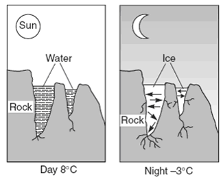
The diagrams  shows a natural process that weathers rock.
 Which statement best explains why this process results in weathering?
a)
frozen water acts as a solute
b)
water expands when it freezes
c)
the mass of water increases when it freezes
d)
frozen water dissolves most types of rock
84.
What is the correct order of the processes?
a)
they all happen at the same time
b)
erosion, weathering, deposition
c)
weathering, erosion, deposition
d)
weathering, deposition, erosion
85.
How do plants weather rocks?
a)
during photosynthesis
b)
when roots grow into cracks of rocks and expand the rock
c)
when the plant moves water from the roots to the leaves
d)
Plants don't weather rocks
86.
How do we know that a rock has been weathered?
a)
it has sharp edges
b)
it has round edges
87.
What creates the u-shaped valley in a mountainous area?
a)
continental glacier
b)
marraine
c)
alpine glacier
d)
arete
88.
When a glacier moves across land it picks up rocks. This process is called
a)
abrasion
b)
plucking
c)
landslide
d)
creep
89.
What small streams and rivers that flow into the main river are called.
a)
Meanders
b)
Gullies
c)
Rills
d)
Tributaries
90.
When a river is flowing with many loops and bends it is called a 
a)
meander
b)
tributary
c)
delta
d)
oxbow lake
91.
the section of a river neqar an ocean or lake that is fan-shaped is called a 
a)
stream
b)
delta
c)
flood plain 
d)
meander
92.
Soil is deposited on the ________ bank of a river
a)
inside
b)
outside
93.
Soil is eroded from the _________ bank of a river.
a)
inside
b)
outside
94.
The best method to prevent erosion is to
a)
remove all trees
b)
build homes
c)
grow plants
d)
mine
95.
What is formed when the curve of a river is separated and becomes its own body of water?
a)
Meander
b)
Tributary
c)
Flood plain
d)
Oxbow lake
96.
Deltas are built up by -
a)
deposition
b)
leaching
c)
abrasion
d)
erosion
97.
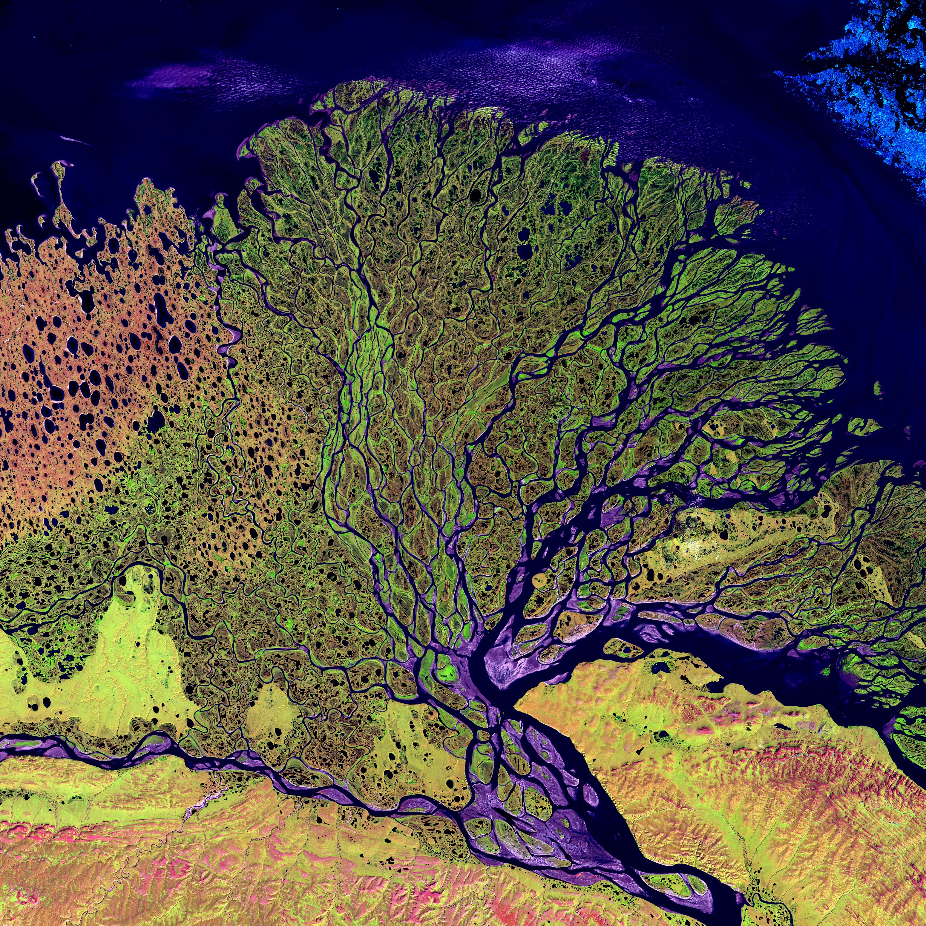
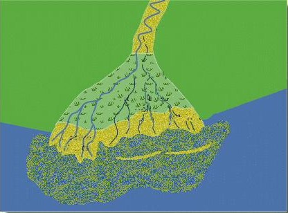
The type of landform shown is at the mouth of the Mississippi River. What is it called?
a)
coastal erosion
b)
a delta
c)
a loess
d)
sand dunes
98.
Which of these coastal landforms are created by deposition?
a)
Cave
b)
Stack
c)
Beach
d)
Wave cut platform
99.
Which of these coastal landforms is created by erosion?
a)
Cave
b)
Tombolo
c)
Beach
d)
Spit
100.
Structure for stopping, slowing, and deflecting long shore currents
a)
groins
b)
jetties
101.
Artificial protection of the beach usually placed at right angles to slow longshore transport
a)
groins
b)
jetties
102.
Till deposited in the front of a glacier
a)
ground moraine
b)
lateral moraine
c)
terminal moraine
d)
medial moraine
103.
This force causes the movement of glaciers
a)
pressure
b)
ice age
c)
gravity
d)
firn
104.
What is a bowl-shaped depression formed by glacial erosion?
a)
cirque
b)
arrete
c)
ice pack
d)
kettle
105.
a sharp, pyramid shaped peak formed by glacial erosion
a)
horn
b)
arete
c)
moraine
d)
kettle
106.
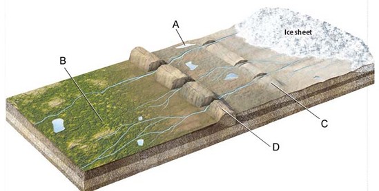
What glacial features are indicated by the labels C and D on the figure?
a)
moraines
b)
outwash plains
c)
kettle lakes
d)
ice sheets
107.
When a glacier retreats and large, partially buried, ice chunks are left behind to melt, these are formed:
a)
Moraine
b)
Prairie pothole
c)
Kettle Lake
d)
Fjord
108.
glacial erosion causes ______ as it moves across the land?
a)
plucking and striations
b)
beaches and sand bars
c)
sea caves and headlands
d)
sand dunes and losses
109.
Poorly graded (unsorted) rock material deposited directly by a glacier.
a)
glacial drift
b)
stratified drift
c)
till
d)
glacier
110.
Forms when a flowing glacier scoops out an area between two mountains. 
a)
U-Shaped Valley
b)
Fjord
c)
Kettle
d)
Moraine
111.
Friction causes the sides of a valley glacier to move more slowly than the center
a)
true
b)
false
112.
The deposit at the furthest point the glacier ever gets.
a)
moraine
b)
ground moraine
c)
recessional moraine
d)
terminal moraine
113.
Glaciers only form near Earth’s poles.
a)
True
b)
False
114.
___________glaciers are growing, while __________ glaciers are shrinking.
a)
Retreating, advancing
b)
Advancing, retreating
115.
_____ are parallel scratch marks on bedrock
a)
Plucking
b)
Abrasion
c)
Straitions
d)
Till
116.
_____ are enormous boulders transported and deposited by glaciers, often far from their source region.
a)
Till
b)
Erratics
c)
Moraines
d)
Fjords
117.
A _____ is a tear-drop-shaped hill created by ice flow over and around till deposit.
a)
drumlin
b)
esker
c)
moraine
d)
erratic
118.
What does this figure illustrate?
a)
U-shaped valley
b)
Cirque
c)
Striation
d)
Fjord
119.
What happens when layers of snow keep piling up?
a)
The bottom layers are compressed into ice
b)
The top layers melt into water
c)
The top layers are compressed into ice
d)
The bottom layers melt into water
120.
Where in Africa could you find a valley glacier?
a)
In a crater
b)
In a warm valley
c)
In a frozen valley
d)
On a frozen mountain peak
121.
Which of the following terms describes how glaciers move?
a)
Quickly
b)
Gradually
c)
Aggressively
d)
Rapidly
122.
Question 11
a)
A
b)
B
c)
C
d)
D
123.
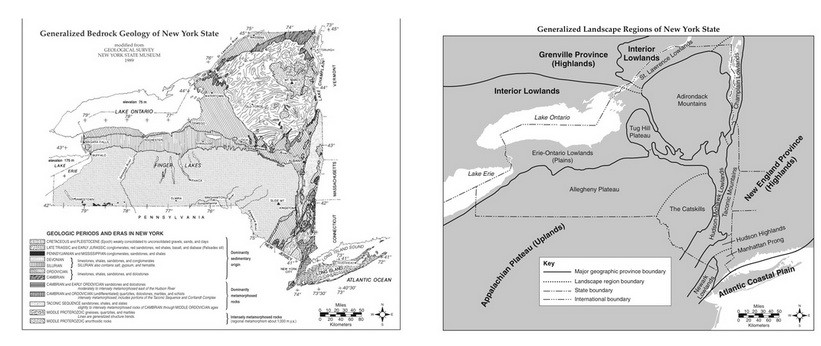
(Question 4) The Generalized landscape regions of New York State are identified chiefly on the basis of
a)
Nearness to Continental Boundaries
b)
Nearness to Major Mountain Ranges
c)
Climatic Conditions
d)
Surface Bedrock Characteristics
124.
(Question 5) New York State Landscape regions are identified and classified primarily by their
a)
Surface Topopgraphy and bedrock structure
b)
Existing vegetation and type of weather
c)
Latitude and longtitude
d)
Chemical Weathering rate and nearness to larget bodies of water
125.
Question 12 The diagram shows a glacial landscape feature forming over time from a melting block of ice.
This glacial landscape feature is best identified as
a)
Kettle Lake
b)
An outwash plain
c)
A Finger lake
d)
A moraine
126.
Question 18
a)
A
b)
B
c)
C
d)
D
127.
According to the ESRT,
the Catskills
are part of which type of landscape region?
a)
plateau
b)
coastal lowland
c)
mountain
d)
plain
128.
a)
The elevation of the entire region will increase.
b)
The limestone will stop dissolving.
c)
The rate of wind erosion will increase.
d)
The landscape features will become more rounded.
129.
According to the ESRT,
the Catskills
are part of which type of landscape region?
a)
plateau
b)
coastal lowland
c)
mountain
d)
plain
130.
The major landscape regions of the United States are identified chiefly on the basis of...
a)
similar surface characteristics
b)
similar climatic conditions
c)
nearness to continental boundaries
d)
nearness to major mountain regions
131.
In which landscape region are New York State's Finger Lakes primarily located?
a)
Adirondack Mountains
b)
Allegheny Plateau
c)
Atlantic Coastal Plain
d)
Erie-Ontario Lowlands
132.
Which New York State landscape region is mostly composed of horizontal sedimentary bedrock at high elevations?
a)
Hudson Highlands
b)
Allegheny Plateau
c)
Taconic Mountains
d)
Atlantic Coastal Plain
133.
The Catskills of New York State are best described as a plateau, while the Adirondacks are best described as mountains. Which factor is responsible for the difference in landscape classification of these two regions?
a)
climate variations
b)
bedrock structure
c)
vegetation type
d)
bedrock age
134.
New York State’s Catskills are classified as which type of landscape region?
a)
mountain
b)
plateau
c)
lowland
d)
plain
135.
A large flat area of land is a ...
a)
Plain
b)
Cape
c)
Bay
d)
Gulf
136.
The block diagram below represents a portion of the Grand Canyon. This region is best classified as a
a)
plateau
b)
mountain
c)
plain
d)
lowland