wayground logo

Free Printable Worksheets

Font size

S
M
L
XL
Worksheets

world geography

Total questions: 122

Worksheet time: 2hrs 40mins

Name
Class
Date
1.
_________________ are useful to geographers because they can sometimes show information better than written text.
a)
maps
b)
flags
c)
national anthems
d)
government seals
2.
A _________________ map shows states, cities, roads, and railroads.
a)
political
b)
physical
c)
flow-line
d)
relief
3.
____________________________ are mapmakers.
a)
cartographers
b)
geographers
c)
epidemiologists
d)
ecologists
4.
A ___________________ explains the symbols, colors, and lines used on a map.
a)
key
b)
scale bar
c)
scale
d)
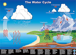
compass rose
5.
A ______________________ illustrates the movement of people, animals, goods, and ideas.
a)
flow-line map
b)
physical
c)
political
d)
relief
6.
Relief and elevation would be shown on a _______________________ map.
a)
physical
b)
political
c)
flow-line
d)
mental
7.
A _________________ is a collection of places with similar characteristics.
a)
region
b)
province
c)
dominion
d)
parish
8.
Geographers divide the world into ______________ in order to study physical and human (cultural) systems.
a)
regions
b)
divisions
c)
districts
d)
sites
9.
Map projections can ________________ the size, shape, or distances of the earth’s landforms.
a)
distort
b)
perfect
c)
color
d)
camouflage
10.
A main purpose of ____________________ maps is to show national boundaries.
a)
political
b)
physical
c)
flow-line
d)
mental
11.
One’s ability to construct an accurate mental map would be helpful if someone were to ask them for __________________________.
a)
directions
b)
the time
c)
their mother's name
d)
the date
12.
Relief maps show changes in _________________.
a)
elevation
b)
temperature
c)
rainfall
d)
population
13.
Particular kinds of information, such as climate or population, would be shown on a ____________________ map.
a)
thematic
b)
mental
c)
relief
d)
landform
14.
The special computer software geographers use to gather different information about the same place is ___________________________________ (GIS).
a)
geographic information system
b)
geographic positioning system
c)
geologic intstitute system
d)
graphic maps inhance system
15.
A _______________ map is the internal image people construct from their knowledge of where places are located.
a)
mental
b)
political
c)
physical
d)
flow-line
16.
Maps that use colors and symbols to show information related to a specific idea are called _______________________ maps.
a)
qualitative
b)
mental
c)
relief
d)
scrambled
17.
_______________________ is the study of the earth and all its variety.
a)
geography
b)
geology
c)
history
d)
sociology
18.
_____________________ are individual features of the earth.
a)
landforms
b)
regions
c)
dominions
d)
skylines
19.
A region is a group of places that all share similar ________________________.
a)
characteristics
b)
color schemes
c)
newscasts
d)
universities
20.
The purpose of a ________________ is to explain the meaning of colors and symbols used on a map.
a)
legend
b)
scale bar
c)
compass rose
d)
scale
21.
____________________ is the shape of Earth’s physical features.
a)
topography
b)
geography
c)
climate
d)
demography
22.
A ________________________ is a scientist who studies the earth and its people.
a)
geographer
b)
geologist
c)
historian
d)
demographer
23.
What is movement?
a)
Tells us how people, goods, recourses, and ideas move from one place to another
b)
Tells us what makes an area special and what makes it different from every other area
c)
Tells us ways in which the places in an area are alike.
24.
Latitude lines run
a)
East/West
b)
North/South
25.
Longitude lines run _________.
a)
East/West
b)
North South
26.
The imaginary line that runs through the middle of the earth east and west is called?
a)
Prime Meridian
b)
Equator
c)
Date Line
27.
Cutting down trees to build houses is an example of which?
a)
Location
b)
Place
c)
Human-Environment Interaction
d)
Movement
28.
People leaving their homes in Syria and travelling to Turkey to avoid ISIS is an example of which?
a)
Human-Environment Interaction
b)
Movement
c)
Absolute Location
d)
Relative Location
29.
The Middle East is an example of which?
a)
Human-Environment Interaction
b)
Relative Location
c)
Movement
d)
Region
30.
The fact that Africa is south of Europe is an example of which?
a)
Movement
b)
Absolute Location
c)
Relative Location
d)
Place
31.
Biochemical warfare that pollutes the water in a country is an example of which?
a)
Place
b)
Human-Environment Interaction
c)
Region
d)
Movement
32.
What is the acronym to remember the Five Themes of Geography?
a)
MAD
b)
MRHELP
c)
PIG
d)
COW
33.
The Five Themes of Geography are the Following:
a)
Place, Region, Interaction, Land-forms, Movement
b)
Place, Region, Interaction, Location, Movement
c)
People, Race, Interaction, Location Movement
d)
Power, Region, Interaction, Location Movement
34.
What are the two types of location geographers are interested in?
a)
Absolute and Relative
b)
Latitude and Relative
c)
GPS and Satellite
d)
General and Relative
35.
Relative location is:
a)
Latitude and Longitude
b)
Given by GPS
c)
a general location, not specific
d)
a specific place:
36.
Absolute location is:
a)
general
b)
not used on GPS
c)
is saying that Two Rivers is in East Hartford
d)
uses latitude and longitude to give a specific area
37.
The theme Place consist of:
a)
Human and Physical characteristics
b)
the movement of people and trade
c)
places that are similar with one another
d)
The location of an area
38.
New England is an example of what theme:
a)
Movement
b)
Region
c)
Location
d)
Place
39.
0 degrees latitude on the globe is the:
a)
Prime Meridian
b)
South Pole
c)
Equator
d)
North POle
40.
The theme movement has to do with what two ideas:
a)
Migration and Trade
b)
Latitude and longitude
c)
Pollution
d)
Human and Physical Characteristics
41.
A company who pollutes the air is an example of what theme:
a)
Place
b)
Movement
c)
Interaction
d)
Region
42.
Two Rivers Magnet Middle School is located at 317 East River Drive East Hartford, CT is an example of what theme.
a)
Location: Absolute
b)
Location: Relative
c)
Place
d)
Region
43.

Why do people often settle near water

a)

ease of transportation and trade

b)

food and water source

c)

attractive scenery

d)

safety

44.
__________ is a map which distorts the size of land area or distance to convey information, relationships or data
a)
Cartogram
b)
Economic 
c)
Choropleth 
d)
Political
45.
This type of map features a variety of symbols and colors
a)
Resource 
b)
Physical 
c)
Topographical
d)
Cartogram
46.
a)
Physical
b)
Political
c)
Cartogram
d)
Topographic 
47.
a)
Physical
b)
Resource 
c)
Political
d)
Topographic
48.
a)
Physical
b)
Political
c)
Topographical
d)
Choropleth
49.
This map depicts-in detail-landforms, lakes and rivers, forests, populated areas, transportation routes and facilities (including roads and railways), and other manmade features
a)
Physical
b)
Topographic 
c)
Economic 
d)
Political 
50.
The primary purpose of this map is to show deserts, mountains, valleys, plains, etc. (elevation)
a)
Topographic
b)
Economic
c)
Political
d)
Physical
51.
___________ maps show how people have divided places on the Earth into countries, states, cities.
a)
Physical 
b)
Political 
c)
Cartogram
d)
Resource
52.
When taking a round globe and making it flat, we run into what problem? 
a)
Functionalism 
b)
Ugliness 
c)
Distortion 
d)
Perfection 
53.
The hydrologic cycle continuously recycles _______ through Earth's systems.
a)
rocks
b)
water
c)
oxygen
d)
carbon dioxide 
54.
The hydrologic cycle is a continuous process driven by energy from the ...
a)
Moon.
b)
Sun.
c)
gravity.
d)
Earth's interior.
55.
What is B?
a)
Evaporation
b)
Condensation
c)
Precipitation
d)
Runoff
56.
What is      D?
a)
Evaporation
b)
Condensation
c)
Precipitation
d)
Runoff
57.
What is C?
a)
Evaporation
b)
Condensation
c)
Precipitation
d)
Runoff
58.
Which stages does liquid water from the ocean turn into water vapor?
a)
condesantion
b)
evaporation
c)
precipitation
d)
run off
59.
Snow, sleet, hail, and rain are all examples of  ________________. 
a)
evaporation
b)
condensation
c)
accumulation
d)
precipitation
60.
What is the hydrosphere?
a)
Water on the earth's surface
b)
Oceans of the Earth
c)
Rivers, oceans and lakes of the Earth
d)
None of the above
61.
What are three stages of the water cycle?
a)
evaporation, condensation, precipitation
b)
condensation, precipitation, hibernation
c)
precipitation, dehydration, evaporation
d)
transpiration, dehydration, condensation
62.
What is the next stage after condensation in the water cycle?
a)
CONDENSATION
b)
GROUNDWATER
c)
PRECIPITATION
d)
RUN OFF
63.
The change of water from a vapor to a liquid.
a)
evaporation
b)
precipitation
c)
condensation
d)
transpiration
64.
The change of water from a liquid to a gas.
a)
evaporation
b)
precipitation
c)
condensation
d)
transpiration
65.
causes evaporation
a)
shaking water
b)
rain
c)
Monster drinks
d)
energy from the Sun or heat
66.
Any form of water that falls from clouds and reaches Earth's surface like hail, snow, sleet, rain;clouds get heavy and the air cannot hold it any longer.
a)
precipitation
b)
transpiration
c)
condensation
d)
clouds
67.
Which is the best example of weathering?
a)
The cracking of rocks caused by the freezing and melting of water
b)
The transportation of sediment in a stream
c)
The condensation of water vapor into droplets in clouds
d)
The formation of a sandbar along the side of a stream
68.
What is the most important factor of climate?
a)
Air Pressure
b)
Ocean Currents
c)
Elevations
d)
Latitude
69.
What is the climate like on the leeward side of the mountain?
a)
arid
b)
cool
c)
moist
d)
humid
70.

What does the E in LAMECOWS stand for?

a)

Economic

b)

Environmental

c)

Educational

d)

Elevation

71.

What does the L stand for in LAMECOWS

a)

Latitude

b)

Logitude

c)

La Nina

d)

Low Pressure

72.

Which best describes El Niño?

a)

The water in the Pacific Ocean gets warmer than normal and causes fewer hurricanes to form.

b)

The water in the Pacific Ocean gets colder than normal and causes more hurricanes to form.

c)

The water in the Pacific Ocean gets colder than normal, and the flow of the jet stream is disrupted.

d)

a periodic reversal of the pattern of

ocean currents and water temperatures in the

mid-Pacific region

73.
What causes La Nina?
a)
cooling of water in the Atlantic Ocean off the coast of South America
b)
cooling water off the Atlantic coast of the US
c)
cooling water in the Pacific Ocean off the coast of South America
d)
warm water in the Pacific Ocean off the coast of South America
74.

What is the process of moving sediments from location to another?

a)

Deposition

b)

Erosion

c)

Weathering

d)

Compaction

75.
The process of breaking up Earth's surface into sediment is called...
a)
sediment
b)
erosion
c)
weathering
d)
deposition 
76.
In the Pacific, hurricanes are called ________.
a)
Cyclones
b)
Tornados
c)
Typhoons
d)
Tsunamis
77.
What is another name for a hurricane below the Equator (in Australia)?
a)
hurricane
b)
matey
c)
cyclone
d)
krikey
78.
Soil is made of
a)
weathered rocks and minerals
b)
dead plants and animals
c)
air and water
d)
all of the above
79.
This type of weathering occurs when rock is physically broken down into smaller pieces of rock.
a)
mechanical weathering
b)
chemical weathering
c)
erosion weathering
d)
deposition
80.
This type of weathering occurs when rocks weaken then break down due to chemical changes in the composition of the rock.
a)
mechanical weathering
b)
chemical weathering
c)
erosion weathering
d)
deposition
81.

As you go to the top of a mountain, what happens to the air pressure?

a)

Nothing

b)

air pressure increases

c)

air pressure decreases

d)

Air pressure goes up and down

82.
How does higher altitude affect climate?
a)
the higher you go above sea level, the colder it gets.
b)
The further you get from the equator, the colder it gets.
c)
The closer you get to the equator, the hotter it gets.
d)
The process by which heat from the sun is trapped near Earth's surface.
83.

As latitude increases, the average annual surface temperature

a)

decreases.

b)

increases.

c)

remains the same.

84.

Why are temperature variations usually not as great on Long Island as they are in central New York State?

a)

Central New York State has a higher elevation.

b)

Central New York State is more heavily wooded.

c)

Long Island has a more southerly latitude.

d)

Long Island is surrounded by a large body of water.

85.

The windward side of the mountain range is

a)

Wet and cool

b)

Wet and hot

c)

dry and cool

d)

dry and hot

86.
As you go to the top of a mountain, what happens to temperature?
a)
Nothing
b)
It increases
c)
It decreases
d)
It goes up and down
87.

Areas that are near the ocean have

a)

mild climate (small range in temperatures)

b)

extreme, harsh climates (large range in temperatures)

88.
Which adjective below BEST describes the climates near the equator?
a)
hot
b)
dry
c)
cold
d)
windy
89.
Warmer climates tend to form around
a)
the North and South Poles
b)
mountains
c)
oceans
d)
the equator
90.

What does the A stand for in LAMECOWS

a)

Air Mass

b)

Amplitude

c)

Atmosphere

d)

Ambient

91.

What does the M stand for in LAMECOWS

a)

Mass

b)

Mondo

c)

Magnitude

d)

Mountains

92.

What does the C stand for in LAMECOWS

a)

Cartogram

b)

Coriolis

c)

Continentality

d)

Continuous

93.

What does the O stand for in LAMECOWS

a)

Ocean Current

b)

Organic

c)

Optimal

d)

Optic

94.

What does the W stand for in LAMECOWS

a)

Weather

b)

Waste

c)

Weathering

d)

Water

95.

What does the S stand for in LAMECOWS

a)

Society

b)

Stasis

c)

Static

d)

Storms

96.
Which climate type is a very cold, very dry frozen grassland?
a)
Subarctic
b)
Tundra
c)
Ice Cap
d)
Humid Continental
97.
The ______ the elevation, the ________ the temperature.
a)
higher, colder
b)
lower, worse
c)
lower, colder
d)
higher, warmer
98.
_______ climate is described as hot and wet, and is located in low latitudes.
a)
Tropical
b)
Dry
c)
Continental
d)
Moderate
99.
What are the characteristics of a desert climate?
a)
Cold & Dry
b)
Hot & Dry
c)
Dry
d)
Cactus filled
100.

Which of the climates is least likely to have precipitation?

a)

arid climate

b)

mediterranean climate

c)

humid continental climate

d)

ice cap climate

101.

Cool or cold temperatures all year. Temperature and rainfall varies by elevation. The higher the elevation the lower the temperatures.

a)

arid climate

b)

Highland climate

c)

tropical rainforest

d)

ice cap climate

102.

mild, rainy winters and hot, dry summers Natural vegetation includes thickets of woody bushes and short trees

a)

arid climate

b)

Highland climate

c)

tropical rainforest

d)

Mediterranean

103.
This sphere includes the continents, the ocean floor, all the rocks on the surface, and all of the sand in the deserts. 
a)
Hydrosphere 
b)
Biosphere 
c)
Atmosphere 
d)
Geosphere 
104.
This sphere is composed of all the living things 
a)
Hydrosphere 
b)
Biosphere 
c)
Atmosphere 
d)
Geosphere 
105.
Water evaporating from the surface of a lake moves from the...
a)
Atmosphere to the geosphere 
b)
Geosphere to the hydrosphere 
c)
Hydrosphere to the atmosphere 
d)
Atmosphere to the hydrosphere 
106.
Oceans, rivers, lakes, and the moisture in the air are all part of which of Earth's spheres? 
a)
Hydrosphere 
b)
Biosphere 
c)
Atmosphere 
d)
Geosphere 
107.
Wind is part of what sphere of Earth?
a)
Windosphere
b)
Atmosphere
c)
Hydrosphere
d)
Airosphere
108.
This includes the gases that surround the earth, giving us a protective layer. 
a)
Hydrosphere
b)
Atmosphere
c)
Lithosphere
d)
Biosphere
109.
What does the theory of continental drift state?
a)
The continents were once joined in a super-continent and have moved over time
b)
Continents are stationary and do not move
c)
The Earth is broken into lithospheric plates that move due to convection currents
d)
none of the above
110.
What is the theory that states that parts of the Earth's crust slowly drift atop a liquid core.
a)
Theory of Evolution
b)
Heliocentric Theory
c)
Geocentric Theory
d)
Continental Drift Theory
111.
What is a divergent plate boundary?
a)
A boundary between two plates that are moving apart
b)
A boundary between two plates that are crashing together
c)
A boundary between two plates that are sliding past each other
d)
A boundary between two plates that are not moving
112.
The type of plate boundary where two plates come together is a .....
a)
Convergent Boundary
b)
Divergent Boundary
c)
Transform Boundary
d)
Plate Boundary
113.
What geologic feature/event would you most likely to find at a divergent boundary between two pieces of oceanic crust?
a)
Rift Valley
b)
Mid-Ocean Ridge
c)
Island Arc
d)
Flat land
114.
What geologic feature/event would you most likely to find at a convergent boundary between two pieces of continental crust?
a)
Volcano
b)
Mountain
c)
Rift
d)
Island Arc
115.
Plates slide past one another at ____________ boundaries.
a)
divergent
b)
convergent
c)
transform
d)
submergent
116.
Which of the following is the name of the ancient supercontinent formed 28 Million Years ago.
a)
Pangea
b)
Gondwanda
c)
Laurasia
d)
Neverland
117.
Oceanic Trenches are formed by _______ plate boundaries
a)
Convergent
b)
Transform
c)
Plate
d)
Divergent
118.
What geologic feature/event you be most likely to find at a transform boundary?
a)
Earthquakes
b)
Volcanoes
c)
Mountains
d)
Rift Valleys
119.
Rainfall occurs mostly on the _____ side of the mountain.
a)
Right
b)
Leeward
c)
Windward
d)
Under
120.

The leeward side is generally a(n) _____ environment.

a)

arid

b)

humid

c)

damp

d)

cold

121.
Weather conditions over time
a)
Atmosphere
b)
Weather
c)
Climate
d)
None of these
122.
Drier area on the leeward side of a mountain
a)
Rainshadow effect
b)
Greenhouse effect
c)
Global warming
d)
none of these