
 Worksheets
3rd Grade Map Skills
Total questions: 31
Worksheet time: 10mins
Name
Class
Date
1.
Which answer shows the tool we
use for cardinal and intermediate
directions?
use for cardinal and intermediate
directions?
a)
line of longitude
b)
compass rose
c)
map
d)
key
2.

What direction is indicated by the number 6?
a)
north
b)
east
c)
south
d)
west
3.

What direction is indicated by the number 2?
a)
north
b)
east
c)
south
d)
west
4.

What direction is indicated by the number 4?
a)
north
b)
east
c)
south
d)
west
5.

What direction do you need to travel to go from the ferris wheel to the Food Market?
a)
South
b)
North
c)
Northwest
d)
East
6.

What direction do you need to travel to get from the swing set to the food market?
a)
East
b)
North
c)
Southeast
d)
West
7.

Which state borders Ohio to the West?
a)
California
b)
Indiana
c)
Pennsylvania
d)
Michigan
8.

Which state is "the state up North"
a)
Canada
b)
Florida
c)
Pennsylvania
d)
Michigan
9.

Which state is on the Southwest border of Ohio?
a)
Kentucky
b)
West Virginia
c)
New York
d)
Florida
10.

West Virginia would be considered in which intermediate direction to Ohio?
a)
South
b)
Southeast
c)
North
d)
Southwest
11.

The Ohio River is _____ of Toledo.
a)
North
b)
East
c)
West
d)
South
12.

_______ is West of Cleveland
a)
Toledo
b)
Columbus
c)
Kentucky
d)
Cincinnati
13.
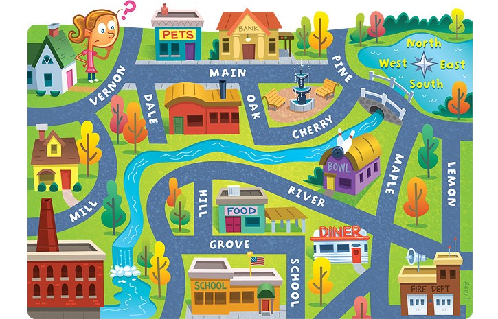
The school is ____ of the pet store.
a)
North
b)
South
c)
East
d)
West
14.
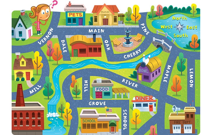
The bank is ____ of the pet store.
a)
East
b)
North
c)
West
d)
South
15.

California (CA) is ______ of
New Jersey (NJ).
New Jersey (NJ).
a)
East
b)
Northeast
c)
North
d)
Southwest
16.

To go from New Jersey (NJ) to Florida (FL) you go _________.
a)
North
b)
South
c)
East
d)
West
17.

North Dakota (ND) is ______ of
Texas (TX).
Texas (TX).
a)
North
b)
East
c)
South
d)
West
18.

Florida (FL) is ______ of
Washington (WA).
Washington (WA).
a)
Northeast
b)
Southwest
c)
Northwest
d)
Southeast
19.

Northeast, Southeast, Northwest, and Southwest are all known as ____________________ directions.
a)
main
b)
cardinal
c)
four
d)
intermediate
20.

The hotel is ____________ of the zoo.
a)
North
b)
South
c)
East
d)
West
21.

The cinema is ______________ of the zoo.
a)
Southeast
b)
North
c)
West
d)
Northwest
22.

If you go south of Ohio, what is the first state you will get to?
a)
Indiana
b)
Michigan
c)
Pennsylvania
d)
Kentucky
23.

What state is directly west of Wyoming?
a)
Indiana
b)
Idaho
c)
South Dakota
d)
Montana
24.

What state is east of New Mexico?
a)
Colorado
b)
Texas
c)
California
d)
Washington
25.
Political Maps show:
a)
The features people have created, such as cities, states, provinces, territories, and countries.
b)
Landforms and bodies of water found in particular areas
c)
Certain information (climate, population, languages, etc.) about a place or region
d)
Directions to making sense of politics
26.
Physical Maps show:
a)
The features people have created, such as cities, states, provinces, territories, and countries.
b)
Landforms and bodies of water found in particular areas
c)
Certain information (climate, population, languages, etc.) about a place or region
d)
Directions to PE class
27.
What is a map?
a)
a picture of a place
b)
something that gives information about a specific place
c)
a visual representation of a place
d)
all of the other answers
28.
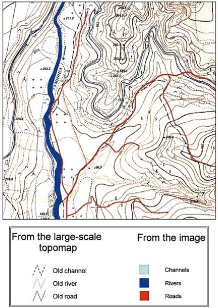
This map is an example of a . . .
a)
Climate Map
b)
Land Use Map
c)
Historical Map
d)
Topographic Map
29.

What is the name of this map feature?
a)
key
b)
grid lines
c)
map
d)
title
30.

What is the capitol of Texas?
a)
S. Padre Island
b)
Austin
c)
Texas
d)
Rio Grande
31.
This is an imaginary line that separates two countries.
a)
state
b)
border
c)
north
d)
capital
100 %

