wayground logo

Free Printable Worksheets

Font size

S
M
L
XL
Worksheets

Geography of Asia

Total questions: 42

Worksheet time: 4hrs 30mins

Name
Class
Date
1.

Which country is between Russia and China?

a)

Turkey

b)

Mongolia

c)

Oman

d)

India

2.

Which country borders Iraq and Yemen?

a)

United Arab Emirates

b)

Iran

c)

Saudi Arabia

d)

Jordan

3.

Which country borders Laos and Cambodia?

a)

Vietnam

b)

Burma

c)

Malaysia

d)

China

4.

Which of the following is an archipelago?

a)

India

b)

Syria

c)

Philippines

d)

Pakistan

5.

Which of the following is between Afghanistan and India?

a)

Nepal

b)

Iran

c)

Turkmenistan

d)

Pakistan

6.

Which country borders Iraq and Turkey?

a)

Syria

b)

Iran

c)

Israel

d)

Yemen

7.
What country is this?
a)
China
b)
North Korea
c)
South Korea
d)
Japan
8.
Where is Taiwan located in relation to China?
a)
Northwest
b)
Southeast
c)
West 
d)
South
9.

The ocean south of Pakistan is the

a)

Atlantic Ocean

b)

Pacific Ocean

c)

Arctic Ocean

d)

Indian Ocean

10.
a)
India
b)
China
c)
Japan
d)
Mongolia
11.
a)
India
b)
China
c)
Japan
d)
Mongolia
12.
a)
Indonesia
b)
Malaysia
c)
Myanmar
d)
Nepal
13.
a)
Indonesia
b)
Malaysia
c)
Myanmar
d)
Nepal
14.
a)
Bhutan
b)
Bangladesh
c)
Laos
d)
Vietnam
15.
a)
Bhutan
b)
Bangladesh
c)
Laos
d)
Vietnam
16.
a)
Brunei
b)
North Korea
c)
South Korea
d)
Cambodia
17.
a)
Taiwan
b)
North Korea
c)
South Korea
d)
Cambodia
18.

The largest continent in the world.

a)

Australia

b)

Russia

c)

Asia

d)

Europe

19.

The landform that forms a natural border between India and China.

a)

Rocky Mountains

b)

Himalayan Mountains

c)

Yangtze River

d)

Great Wall of China

20.

The sea that is located between China and the Korean Peninsula.

a)

Yellow Sea

b)

South China Sea

c)

Sea of Japan

d)

Caribbean Sea

21.

The body of water that connects the Pacific and Indian oceans.

a)

Yellow Sea

b)

Sea of Japan

c)

South China Sea

d)

Yangtze River

22.

The country that is a large island near North and South Korea.

a)

Vietnam

b)

Japan

c)

China

d)

Mongolia

23.
What country?
a)
Afghanistan
b)
Iran
c)
Iraq
d)
Israel
24.
What country?
a)
Afghanistan
b)
Iran
c)
Iraq
d)
Israel
25.
What country?
a)
Afghanistan
b)
Iran
c)
Iraq
d)
Israel
26.
What country?
a)
Afghanistan
b)
Iran
c)
Iraq
d)
Israel
27.
What is this physical feature?
a)
Jordan River
b)
Persian Gulf
c)
Red Sea
d)
Euphrates River
28.
What is this physical feature?
a)
Euphrates River
b)
Jordan River
c)
Persian Gulf
d)
Red Sea
29.
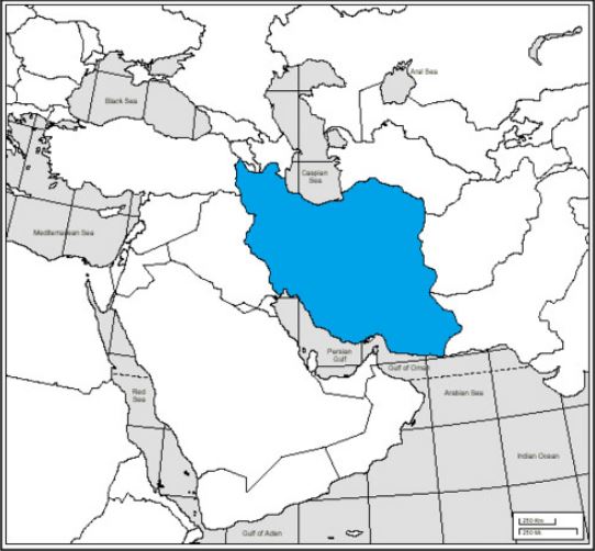
What country?
a)
Saudi Arabia
b)
Turkey
c)
Israel
d)
Iran
30.
What is this physical feature?
a)
Red Sea
b)
Strait of Hormuz
c)
Tigris River
d)
Suez Canal
31.
What country?
a)
Iran
b)
Iraq
c)
Turkey
d)
Saudi Arabia
32.

Red Sea

a)

1

b)

2

c)

5

d)

6

33.

Arabian Sea

a)

1

b)

2

c)

7

d)

6

34.

Israel

a)

3

b)

4

c)

5

d)

6

35.

Of all the 7 continents, Asia has ___________.

a)

the largest landmass and second largest population.

b)

the largest landmass and greatest population.

c)

the greatest population and second largest landmass.

d)

the greatest population and smallest overall landmass.

36.

___________ is a country that is divided between North and South due to economics.

a)

Korea

b)

Kazakhstan

c)

Japan

d)

Cambodia

37.

What is a correct relative location for China?

a)

north of Vietnam

b)

east of Japan

c)

west of Thailand

d)

south of India

38.

Which region stretches from China to Mongolia and is the largest desert in Asia?

a)

Sahara

b)

Gobi

c)

Atacama

d)

Nile Basin

39.

Which mountain is part of the Himalayas and the tallest mountain in the world?

a)

Mount Everest

b)

Mount McKinley

c)

Mount Fuji

d)

Mount Ranier

40.
What country is being featured? 
a)
South Korea
b)
North Korea
c)
Japan 
d)
China
41.
What river is featured here?
a)
Indus River
b)
Ganges River
c)
Yangtze River
d)
Huang He River
42.
What country is shown here? 
a)
Japan
b)
North Korea
c)
South Korea
d)
China