wayground logo

Free Printable Worksheets

Font size

S
M
L
XL
Worksheets

Geography Terms: Q43-RC-Wk3 TEST 2-25-21

Total questions: 84

Worksheet time: 53mins

Name
Class
Date
1.

What is a river?

a)

The largest natural body of water that flows

b)

The smallest natural body of water that flows

c)

A medium sized flow of water

2.

How are subduction volcanoes formed?

a)

from mountains over a long period of time

b)

when tectonic plates make contact and with their friction melt the Earth's crust, the intense heat melts the rock below the crust turning it into magma

c)

when the Earth removes its excess waste

d)

when magma takes up too much space within the earth and causes subduction

3.

What is a gulf?

a)

A type of sport

b)

A body of land completely surrounded by water

c)

A piece of land surrounded by water

d)

A deep body of water nearly surrounded by land as in the shape of the letter "C"

4.

How is a canal formed?

a)

By nature

b)

Artifically

c)

Erodes over time

d)

By animals

5.

In technical terms, both a gulf and a bay are the same things, and the only difference is that:

a)

A bay is much larger than a gulf.

b)

both are exactly the same

c)

A gulf is much larger than a bay.

6.

Imaginary lines traveling from North to South on the Earth are called:

a)

Tropic of Cancer lines

b)

Longitude lines

c)

Latitude lines

d)

Tropic of Capricorn lines

7.

Imaginary lines traveling East to West on the Earth are called:

a)

Equator lines

b)

Latitude lines

c)

Longitude lines

d)

International Date lines

8.

A map that allows the reader to distinguish between mountains, valleys and appears as if 3D is called a:

a)

Topographic map

b)

creative map

c)

Political map

9.

A body of land extending from a larger body of land and formed primarily from erosion is called a:

a)

inlet

b)

cape

c)

cliff

d)

peninsula

10.

An extremely large body of ice that, over thousands of years, form valleys, canyons and mountains because it is constantly moving is called a:

a)

Greenland

b)

iceberg

c)

glacier

d)

Iceland

11.

How does a glacier move ?

a)

Earthquakes

b)

Wind

c)

its own weight

d)

All of the above

e)

All of the above but it is primarily the weight that moves it

12.

Any point on the Earth where the Sun's rays strike the Earth directly is called the solar:

a)

eclipse

b)

zenith

c)

rays

13.

A body of land surrounded by water all the way around is called:

a)

a continent

b)

an island

c)

a peninsula

d)

a lake

14.

a very narrow body of land that connects two larger bodies of land is called:

a)

an isthmus

b)

a straight

c)

a land bridge

d)

a peninsula

15.

A body of land protruding from a larger body of land and surrounded by water on three side sis called:

a)

a cape

b)

a peninsula

c)

a straight

d)

a plank

16.

A flat grassy, sweeping landmass that generally does not change much in elevation and occurs as lowlands along the bottoms of valleys or on the doorsteps of mountains are called:

a)

savannas

b)

plains

c)

grassy deserts

d)

prairies

17.

The mouth of a river as it empties itself into the ocean or sea is called:

a)

a dredge

b)

a water fall

c)

a delta

d)

an isthmus

18.

What word means: a narrow strip of land connecting two larger pieces of land?

a)

continent

b)

isthmus

c)

settlement

d)

strait

19.

A large sea or ocean inlet, deeper than a bight and wider than a fjord; or a narrow sea or ocean channel between two bodies of land is called:

a)

a canyon

b)

a sound

c)

a water canyon

d)

a bay

20.
Earth is divided into ________ continents.
a)
4
b)
5
c)
6
d)
7
21.
What imaginary line runs around the earth halfway between the North and South Poles?
a)
Prime Meridian
b)
Tropic of Cancer
c)
Tropic of Capricorn
d)
Equator
22.
What is this a picture of?
a)
Gulf
b)
Canyon
c)
Plateau
d)
Delta
23.
A _______ is flat low-lying land built up from soil carried downstream by a river and deposited at its mouth.
a)
Delta
b)
Seacoast
c)
Cape
d)
Valley
24.
What do you call the place where a river begins?
a)
Source
b)
Beginning
c)
Starting Place
d)
Sound
25.

A type of biome where the tree growth is hindered by low temperatures and short growing seasons is called:

a)

tundra

b)

forest

c)

ice desert

26.
Earth is divided into _____ hemispheres.
a)
2
b)
4
c)
6
d)
8
27.
Part of a large body of water that extends into a shoreline is called a ________.
a)
Peninsula
b)
Cape
c)
Basin
d)
Gulf
28.
The Prime Meridian runs through ______________.
a)
Greenwich, France
b)
Greenwitch, England
c)
Greenwich, England
d)
Greengrass, Spain
29.
You can use lines of longitude and latitude to find the absolute location of a place on earth.
a)
True
b)
False
30.
Lines of Latitude measure the distance _____ and _____ of the Equator.
a)
North and South
b)
East and West
c)
South and West
d)
North and East
31.
What do you call a narrow stretch of water that joins two larger bodies of water?
a)
Isthmus
b)
Strait
c)
Sea
d)
Ocean
32.
What do you call a body of land surrounded by water on three sides?
a)
Peninsula
b)
Strait
c)
Isthmus
d)
Tributary
33.
The _______ (of a river) is the place where a stream or river flows into a larger body of water.
a)
current
b)
source
c)
mouth
d)
tributary
34.
An area of flat or rolling land at a high elevation, around 300-3,000 feet high.
a)
plateau
b)
lowland
c)
canyon
d)
valley
35.
The main directions (north, south, east, west) on a compass rose.
a)
intermediate directions
b)
cardinal directions
c)
immediate directions
d)
locator directions
36.
Something on a map that stands for something else.
a)
legend
b)
key
c)
symbol
d)
drawing
37.

A large body of water surrounded by land all the way around is called:

a)

a lake

b)

a sea

c)

a pond

d)

a crevice

38.
This shows the relationship between distances on a map and the actual distance.
a)
key
b)
compass rose
c)
scale
d)
locator
39.
Earth's largest bodies of water.
a)
lakes
b)
seas
c)
reservoirs
d)
oceans
40.
A small drawing on a map that is used to help you find directions.
a)
legend
b)
scale
c)
locator
d)
compass rose
41.
The gives the meaning of each symbol on a map.
a)
compass rose
b)
locator
c)
key 
d)
dictionary
42.
The directions of northeast, southeast, northwest, and northeast.
a)
infinite directions
b)
intermediate directions
c)
intermittent directions
d)
intolerable directions
43.
A map that shows the natural features of Earth.
a)
physical map
b)
transportation map
c)
historical map
d)
bumpy map
44.
A map used to show you how you can travel from one place to another.
a)
road map
b)
transportation map
c)
historical map
d)
physical map
45.
A map that shows the landforms, or shapes that make up Earth's surface.
a)
shape map
b)
political map
c)
landform map
d)
indicator map
46.
A map that shows information about past events and where they occurred.
a)
war map
b)
hysterical map
c)
political map
d)
historical map
47.
A map that shows information such as cities, capitals, states, and countries.  This map uses lines to show borders.
a)
physical map
b)
political map
c)
color map
d)
landform map
48.
The study of the physical features of the Earth and the people that live here.
a)
Astronomy
b)
Geography
c)
Physics
d)
Geothermal
49.
A large area of flat land with few trees and a lot of space.
a)
mountain
b)
plate
c)
plain
d)
projection
50.

The largest of any body of constantly flowing water is called:

a)

a river

b)

a brook

c)

a stream

d)

a trickle

51.

The smallest of any body of constantly flowing water is called:

a)

a river

b)

a brook

c)

a stream

d)

a trickle

52.

a scientific theory describing the large-scale motion of seven large plates and the movements of a larger number of smaller plates of the Earth's lithosphere is called:

a)

plate tectonics

b)

tectonic plates

c)

continental drift

d)

Pangea

53.

The imaginary line on the Earth, dividing it into northern and southern hemispheres is called the:

a)

The Prime Meridian

b)

The Tropic of Cancer

c)

Equator

d)

The Tropic of Capricorn

54.

The imaginary lines traveling North to South on the Earth break-up the Earth into how many sections?

a)

12

b)

48

c)

60

d)

24

55.
What imaginary line determines climate?
a)
Tropic of Cancer
b)
Prime Meridian
c)
Equator
d)
Tropic of Capricorn
56.
A mound of earth with a rounded top, much smaller than a mountain is... 
a)
Mountain
b)
Mount Everest 
c)
Hill
d)
Plateau 
57.
A large crack in the earth caused by a river or earthquake is... 
a)
Canyon
b)
Ocean
c)
State
d)
Isthmus 
58.
Mount Everest is in the...
a)
Alps
b)
Rocky Mountain
c)
Himalayas 
d)
Grand Canyon 
59.
What is geography?
a)
the study of Earth
b)
the study of fossils
c)
the study of people
d)
the study of history
60.
Philippines, China, Japan are located in which continent?
a)
Europe
b)
Asia
c)
Africa
d)
Antarctica
61.
In which continent is Egypt a part of?
a)
Australia
b)
Asia
c)
Europe
d)
Africa
62.
This continent has three countries (Mexico, USA, Canada)
a)
South America
b)
Africa
c)
North America
d)
Asia
63.
Name the largest ocean
a)
Indian Ocean
b)
Pacific Ocean
c)
Atlantic
d)
Arctic
64.
This continent has no volcanoes
a)
Africa
b)
Australia
c)
Europe
d)
North America
65.
Mariana Trench can be found in this part of the ocean
a)
Indian
b)
Atlantic
c)
Southern
d)
Pacific
66.
the northern-most ocean in the world
a)
Arctic Ocean
b)
Atlantic Ocean
c)
Pacific Ocean
d)
Indian Ocean
67.
The point on the southern hemisphere that is the farthest south (90 degrees south of the equator)
a)
North Pole
b)
South Pole
c)
Equator
d)
Canada
68.
the term for one-half of a globe or one-half of the planet Earth
a)
Sphere
b)
Legend
c)
Prime Meridian
d)
Hemisphere
69.
Largest continent in the world
a)
Africa
b)
United States
c)
Asia
d)
Europe
70.
imaginary line found at zero degrees longitude
a)
Prime Meridian
b)
Equator
c)
Longitude
d)
Latitude
71.
Ocean found to the East of the United States
a)
Pacific
b)
Indian
c)
Atlantic
d)
Australian
72.
Ocean found to the South of Asia
a)
Atlantic
b)
Pacific
c)
Asian
d)
Indian
73.
Latitude and Longitude are measured in ________.
a)
inches
b)
Feet
c)
Degrees
d)
Grams
74.
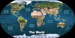
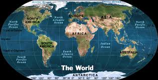
What is the continent that is pink?
a)
North America
b)
South America
c)
Asia
d)
Australia
75.
What is the continent that is blue?
a)
Africa
b)
Australia
c)
Antarctica
d)
Asia
76.
What is the continent that is red?
a)
North America
b)
Europe
c)
Africa
d)
Australia
77.
What is the continent that is dark green?
a)
North America
b)
South America
c)
Europe
d)
Australia
78.
What is the continent that is yellow?
a)
Africa
b)
Australia
c)
Asia
d)
Antarctica
79.
What is the continent that is orange?
a)
Africa
b)
Australia
c)
Antarctica
d)
Asia
80.
What is the continent that is light green?
a)
North America
b)
South America
c)
Africa
d)
Australia
81.
Which continents are completely surrounded by water?
a)
South America and North America
b)
Africa and Asia
c)
Europe and Asia
d)
Australia and Antarctica
82.
How would you describe Europe's location in relation to Asia
a)
Europe is located east of Aisa.
b)
Europe is located west of Asia.
c)
Europe is located south of Asia.
d)
Europe is located north of Asia
83.
Which example best describe absolute location.
a)
Evans school is close to PSA
b)
My house next to the LA Zoo
c)
I live next to Walmart
d)
Australia is 23.5° S and 135° E
84.
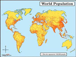
Using the population map, which statement is most accurate.
a)
Most people live in North America
b)
Australia has a larger population than Europe
c)
Larger populations are near water
d)
South America has the largest population