wayground logo

Free Printable Worksheets

Font size

S
M
L
XL
Worksheets

Social Studies 5 themes and map

Total questions: 75

Worksheet time: 2hrs 43mins

Name
Class
Date
1.
The latitude and longitude of a place?
a)
Relative location
b)
Absolute location
c)
Formal Region
d)
Prime Meridian
2.
How people impact their environment is included in which theme of geography?
a)
Location
b)
Place
c)
Movement
d)
Human-Environment Interaction
3.
Location, Place, Regions, Movement, and Human-environment interact are called the
a)
tools of geography
b)
5 themes
c)
momentos of time
d)
tutorials of geography
4.
Line that separates the globe North and South.
a)
Equator
b)
Prime Meridian
c)
Latitude
d)
Longitude
5.
The United States & Canada are located in which hemispheres?
a)
Northern & Eastern
b)
Southern & Eastern
c)
Northern & Western
d)
Southern & Western
6.
What is this called?
a)
North, South, East, West
b)
Compass Rose
c)
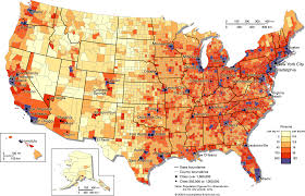
A map
d)
A map key
7.
What type of map is this?
a)
Population 
b)
Physical
c)
Political
d)
Climate 
8.
What is a Region
a)
Tells us ways in which the places in an area are alike
b)
Tells us what makes an area special and what makes it different from every other area
c)
Tells us where people and places are
9.
What is movement?
a)
Tells us how people, goods, recourses, and ideas move from one place to another
b)
Tells us what makes an area special and what makes it different from every other area
c)
Tells us ways in which the places in an area are alike.
10.
Latitude lines run
a)
East/West
b)
North/South
11.
Longitude lines run _________.
a)
East/West
b)
North South
12.
The imaginary line that runs through the middle of the earth east and west is called?
a)
Prime Meridian
b)
Equator
c)
Date Line
13.
People leaving their homes in Syria and travelling to Turkey to avoid ISIS is an example of which?
a)
Human-Environment Interaction
b)
Movement
c)
Absolute Location
d)
Relative Location
14.
The Middle East is an example of which?
a)
Human-Environment Interaction
b)
Relative Location
c)
Movement
d)
Region
15.
The fact that Africa is south of Europe is an example of which?
a)
Movement
b)
Absolute Location
c)
Relative Location
d)
Place
16.
Biochemical warfare that pollutes the water in a country is an example of which?
a)
Place
b)
Human-Environment Interaction
c)
Region
d)
Movement
17.
The European Union is a group of countries that share similar economic and government policies, in addition to all being located near one another and sharing a common history.
a)
Human Environment Interaction
b)
Place
c)
Region
d)
Location
18.
Fruit grown in South America is shipped to your local grocery store.
a)
Region
b)
Location
c)
Movement
d)
Human Interaction
19.
Let's meet at Walmart near the mall is an example of which?
a)
Location
b)
Human Interaction
c)
Place
d)
Region
20.
Let's meet at Walmart near the mall is an example of which?
a)
Location
b)
Human Interaction
c)
Place
d)
Region
21.
What is movement?
a)
Tells us how people, goods, recourses, and ideas move from one place to another
b)
Tells us what makes an area special and what makes it different from every other area
c)
Tells us ways in which the places in an area are alike.
22.
What places have in common: This groups these places together.
a)
Region
b)
Place
c)
Movement
d)
Landform
23.

What is A on the map?

a)

Rocky Mountains

b)

Pacific Ocean

c)

Atlantic Ocean

d)

Great Plains

24.

What is Geography?

a)

It is the study of our earth; our home.

b)

Anything that can be mapped!

c)

A tracker

d)

Place

25.

World map shows what two things?

a)

continents and oceans

b)

roads and road signs

c)

mountains and waterways

d)

rainfall and snowfall

26.

What are the 5 parts of a map?

a)

Latitude, longitude, hemisphere, theme, electricity

b)

I Don't know

c)

Title, Scale, Compass rose, key, and grids.

27.

What are the 5 themes of geography?

a)

I don't know

b)

Earth, mars, sun, stars, mercury

c)

Notebook, lunch, book bag, computer, camera

d)

Place, Location, HEI, Movement, and Region

28.

What is a City-State?

a)

Who knows? ;-;

b)

When there is a surplus of food people no longer have to hunt and gather all day.

c)

an early city that was like a small independent country with its own land and government

d)

a form of government in which the ruling power is in the hands of one person

29.
Economists are concerned with studying ______________.
a)
the economy
b)
history
c)
geography
d)
government
30.
Political Scientists are concerned with studying ______________.
a)
the economy
b)
history
c)
geography
d)
government
31.
Historians are concerned with studying ______________.
a)
the economy
b)
history
c)
geography
d)
government
32.
Geographers are concerned with studying ______________.
a)
the economy
b)
history
c)
geography
d)
government
33.
________ location describes where a location is based upon other locations.  For example the United States is south of Canada, north of Mexico, and west of Europe.
a)
Absolute
b)
Relative
c)
Map
d)
Geographic
34.
Lines of Latitude run from north to south.
a)
True
b)
False
35.
Lines of Longitude run from north to south.
a)
True
b)
False
36.
If you needed help figuring out how to drive somewhere you would want to use a _______________.
a)
map
b)
globe
c)
friend
d)
none of the above
37.

Your address is an example of

a)

relative location

b)

absolute location

c)

place

38.

The two types of geography are

a)

physical and location

b)

physical and human

c)

human and place

d)

none of the above

39.

What do geographers use to organize the information they gather about a place?

a)

charts

b)

the five themes of geography

c)

tables

d)

none of the above

40.

Which is the best representation of the earth?

a)

map

b)

globe

c)

picture

d)

drawing

41.

Which of the following is a global problem?

a)

poverty

b)

Flint water crisis

c)

California wild fires

42.

A group of states considered to be in the Southern part of country is an example of

a)

place

b)

movement

c)

absolute location

d)

region

43.

Location H is located at which coordinates?

a)

60oN, 120oE

b)

90oN, 30oE

c)

10oS, 40oW

d)

30oN, 90oE

44.

Location D is located at which coordinates?

a)

30oN, 90oW

b)

90oN, 30oW

c)

10oN, 40oW

d)

30oN, 90oE

45.

Which point is located at 30oS, 150oE?

a)

K

b)

D

c)

E

d)

G

46.

Which point is located at 30oN, 90oW?

a)

K

b)

D

c)

E

d)

G

47.
North and South America are in what hemisphere?
a)
Northern
b)
Southern
c)
Western
d)
Eastern
48.
Europe, Asia and North America are in what hemisphere?
a)
Northern
b)
Southern
c)
Western
d)
Eastern
49.
What is the name of this line at 0 degrees latitude?
a)
Prime Meridian
b)
Equator
c)
North Pole
d)
South Pole
50.
What is the name of the line at zero degrees longitude?
a)
Equator
b)
Prime Meridian
c)
North Pole
d)
South Pole
51.
What is the approximate location of G?
a)
100oW, 40oN
b)
40oN, 100oW
c)
40oS, 100oW
d)
40oN, 100oE
52.
a)
The map show the lines of longitude.
b)
The map shows the lines of latitude.
53.
a)
The map shows lines of longitude.
b)
The map shows lines of latitude.
54.
To locate a place on the earth, you need to look at...
a)
where the lines of latitude and longitude meet
b)
the lines of latitude only
c)
the lines of longitude only
d)
the compass rose
55.
Which STATE is located at...
120°W, 45°N
a)
WA
b)
OR
c)
UT
d)
ND
56.
Which STATE is located at...
100°W, 48°N
a)
NM
b)
ND
c)
SD
d)
CO
57.

What is the name of this object?

a)

map symbol

b)

map key

c)

map scale

d)

compass rose

58.

a map feature that explains the meaning of colors and symbols used on a map

a)

map conents

b)

map glossary

c)

Map key

d)

map index

59.
What kind of map will show me the states in the United States?
a)
Physical
b)
Climate
c)
Economic/Product or Resource
d)
Political
60.
True or False: A physical map will show you the boundaries of all of the states in The United States.
a)
True
b)
False
61.
mapmaking; the writing involved in making maps or charts.
a)
photography
b)
biography
c)
cartography
d)
seismograph
62.

A pattern formed as the lines of latitude and longitude cross one another.

a)

Compass

b)

Map scale

c)

Legend/key

d)

Grid system

63.
This line measures 0 degrees longitude:
a)
Equator
b)
International Date Line
c)
Meridians
d)
Prime Meridian
64.
The 0 degree line of latitude is the ___________.
a)
Equator
b)
Prime Meridian
c)
International Date Line
d)
Contour line
65.
What is the reason why latitude lines NEVER intersect? 
a)
They converge at the poles
b)
They are cool
c)
They are vertical lines 
d)
They are parallel
66.
Name Continent C!
a)
Antarctica
b)
Europe
c)
Asia
d)
North America
67.
Continent F is ________.
a)
Antarctica
b)
Australia
c)
Europe
d)
North America
68.
Name Ocean #1!
a)
Indian
b)
Pacific
c)
Atlantic
d)
Southern
69.
What is a map scale?
a)
a tool to measure distance
b)
a tool to tell direction
c)
a tool to start a fire
d)
a tool to build a house
70.
Which of the following is NOT a continent?
a)
Africa
b)
North America
c)
Germany
d)
Europe
71.

Identify this map.

a)

Population density map

b)

Physical Map

c)

Road map

72.
How many states are in the U.S.?
a)
25
b)
100
c)
50
d)
3
73.
How many continents are there?
a)
4
b)
1
c)
5
d)
7
74.

What is the proper way to write your name

a)

Last, First

Grade

Date

b)

Last, Date, Grade

c)

Grade, First, Last, Date

d)

Last, First

Date,

Grade

75.

What College did President Obama Attend

a)

Harvard

b)

Princeton

c)

Akron U

d)

Howard