wayground logo

Free Printable Worksheets

Font size

S
M
L
XL
Worksheets

Ap Human Geo 1st 9 weeks Review 2019

Total questions: 111

Worksheet time: 1hrs 8mins

Name
Class
Date
1.
The location of a place using the latitude-longitude grid is called: 
a)
A.  referenced location 
b)
A.  central location
c)
A.  relative location
d)
A.  absolute location 
2.
The location of a place in relationship to other places or features around it is called: 
a)
absolute location
b)
relative location
c)
site
d)
situation
3.
Scale is…                                     
a)
the system used by geographers to transfer locations  from a globe to a map
b)
the extent of spread of a phenomenon over a given area
c)
 the difference in elevation between two points in an area
d)
 the relationship between the length of an object on a map and that feature on the landscape
4.
The process of the spread of an idea and/or dissemination of an innovation from its source area to other cultures, is the process of cultural: 
a)
diffusion
b)
simultaion
c)
adaptation
d)
movement
5.
The physical qualities of the original location for a city is referred to as the
a)
site
b)
situation
c)
relative location
d)
absolute location
6.
Places that share similar characteristics are called 
a)
human systems
b)
environments
c)
regions
d)
physical systems
7.
The physical environment causes social and cultural development.
a)
Cultural Environmentalism
b)
Environmental Possibilism
c)
Environmental Determinism
d)
Cultural Possibilism
8.
The idea that one's environment is responsible for who people are and how they live
a)
Positivism
b)
'Merica
c)
Possibilism
d)
Environmental Determinism
9.
The location of a place based on nearby characteristics.
a)
site
b)
regionalism
c)
situation
d)
place
10.

What is the purpose of a choropleth map?

a)

To make life easier for geographers

b)

To visualise which countries have a higher HDI using different colours in a map

c)

A choropleth map provides an easy way to visualize how a measurement a variable varies across a geographic area.

d)

To make a map look more appealing

11.

Look at the map showing the number of doctors per 1000 inhabitants. How many countries have more than 10 doctors per 1000 inhabitants?

a)

1

b)

None

c)

3

d)

2

12.

a special purpose map that uses color to show population density

a)

physical map

b)

political map

c)

elevation map

d)

choropleth

13.
Thomas Malthus believed that
a)
the government should encourage population growth in order to fully staff the factories being built during the Industrial Age.
b)
the world would soon be overpopulated because population grows at an exponential rate while the food supply increases at an arithmetic rate.
c)
the world would find new sources of food production to offset population growth.
d)
population increase will continue because many religions discourage the use of contraceptives.
14.

Based on the map, which area is most densely populated?

a)

East Asia

b)

Northern Europe

c)

Western North America

d)

Central South America

e)

Southern Africa

15.

Which might explain the asymmetrical part of the population pyramid?

a)

A high death rate among men aged 20 to 50

b)

A large temporary immigrant worker population

c)

An over counting of children during the census

d)

An epidemic with high rate of mortality among the elderly

e)

A major war fought in the years 2006 to 2010

16.
In stage 4 countries dependency ratio is nearly 
a)
1:2
b)
1:6
c)
1:4
d)
1:3
17.
If the GNP(Gross National Product) increases the birth rate of that country?
a)
decreases
b)
increases slowly
c)
doesn't change
d)
increases rapidly
18.
In what stage are most European countries?
a)
1
1
b)
2
c)
3
d)
4
19.
What does an "upside down" population pyramid indicate?
a)
lots of children
lots of children
b)
lots of middle age people
c)
lots of elderly/older people
d)
lots of teens
20.
The ratio of people who are too young or too old to work compared to the working population is called the
a)
dependency ratio
b)
population pyramid
c)
interconnected ratio
d)
retirement ratio
21.
The average number of children a woman will have in her lifetime is the
a)
birth rate or CBR
b)
natural increase or NIR
c)
mortality rate
d)
total fertility rate or TFR
22.
This caused a jump in the worlds' population.
a)
the Renaissance
b)
the Industrial Revolution
c)
the Medical Revolution
d)
the Scientific Revolution
23.
The world's most populated region is 
a)
North America
b)
East Asia
c)
South Asia
d)
Africa
24.
What type of agricultural density happens in a country with a large amount of arable land and a small number of farmers?
a)
high physiological density
b)
low arithmetic density
c)
high agricultural density
d)
low agricultural density
25.
The Earth area of permanent human settlement is called the ____________.
a)
ecumene
b)
hot zone
c)
geophenom
d)
civilized world
26.
How are Stages 1 and 4 of the demographic transition model similar?
a)
both have low growth rates
b)
both have low life expectancies
c)
both have low dependency ratios
d)
both have low death rates
27.
ARABLE land is land suitable for ____________.
a)
raising livestock, like cattle
b)
Agriculture, or farming
c)
growing cactus, it means desert
d)
wind farming
28.
Which of the following is a pull factor?
a)
Insufficient Food Supply
b)
High Crime Rate in Native Country
c)
Higher Paying jobs in New Country
d)
High Crime Rate in New Country
29.
Model that explains changes in population demographics in countries at different time periods.
a)
Distant Decay Model 
b)
Demographic Transition Model 
c)
Overpopulation Model 
d)
 Epidemiologic Transition Model
30.
Which areas of the world generally have net "out" migrations?
a)
Asia and North America
b)
Africa and Europe
c)
Africa and Asia
d)
Latin America and Europe
31.
According to Ravenstein which of the following is NOT true?
a)
Most migrants are young adults.
b)
Most migration is over very long distance
c)
Migration is most often for economic reasons.
d)
Migration occurs in steps.
32.
The wave of immigrants around 1900 to 1915 was different from earlier waves of migration because most were from what area?
a)
Southern and Eastern Europe
b)
Asia
c)
Africa
d)
Latin America
33.
Since the 1980s most US In-Migration has come from
a)
Europe
b)
East Asia
c)
Latin America
d)
South Asia
34.
Most migrants move for 
a)
economic reasons
b)
cultural reasons
c)
environmental reasons
d)
persecution reasons
35.
Population in the US originally moved west but has more recently begun to move where?
a)
been stationary
b)
moved north
c)
moved south
d)
moved back east
36.
If a country's Immigration is LESS than it's Emigration it has
a)
net in-migration
b)
net out-migration
c)
it's population is increasing
d)
it needs to set quota laws
37.
Which of the following is a PULL factor?
a)
A hurricane
b)
failed harvest
c)
increase in taxes
d)
opening a new factory
38.
The Atlantic Ocean is an example of
a)
an environmental push factor
b)
an intervening obstacle
c)
an environmental  pull factor
d)
an economic factor
39.
What is an example of forced migration?
a)
Spanish moving to Mexico
b)
African slaves brought to the Americas.
c)
Syrians moving to Turkey
d)
African Americans moving north at the end of the civil war
40.
Who is migratory over LONG distances?
a)
women with children
b)
young unmarried men
c)
old people
d)
young families
41.
In the 1840's millions Irish migrated to the US because of 
a)
widespread flooding
b)
a farming disaster that killed the potato crop
c)
English government take over
d)
the need for religious freedom
42.
Brain drain is
a)
when you can't come up with the answer on a test
b)
emigration from MDCs to LDCs
c)
emigration of talented and smart people
d)
forcing emigration for political reasons
43.
Geographers group like things together into regions in order to make them easier to study.  What type of region would a corn field be?
a)
Perceptual
b)
Formal
c)
Functional
d)
Vernacular
44.
The physical qualities of the original location for a city is referred to as the
a)
site
b)
situation
c)
relative location
d)
absolute location
45.
The map projection with the greatest amount of distortion, although visually appealing because of its nice, straight lines, is called _____.
a)
Mercator
b)
Gall-Peters
c)
Azimuthal
d)
Homolosine
46.
Physical characteristics of a place (ex. climate, water bodies, topography, soil, vegetation, elevation) are known as
a)
Site
b)
Situation
c)
Absolute location
d)
Physical geography
47.
The map shown here is what type of scale.
a)
Small Scale
b)
Large Scale
c)
Medium Scale
d)
Urban Scale
48.
What type of map projection is this?
a)
Peter's Projection
b)
Robinson Projection
c)
Azimuthal Projection
d)
Mercator Projection
49.
Which key term does this image best represent?
a)
Cultural landscape
b)
Toponym
c)
Urbanization
d)
Physical landscape
50.
Individuals of a population who exit an area.
a)
Immigration
b)
Emigration
c)
Mitigation
d)
Lingation
51.
The point in which an area cannot hold any more individuals in an area is called its what?
a)
carrying capacity
b)
capital capacity
c)
carrying capability
d)
limiting point
52.
Which stage of the Demographic Transition Model is Brazil currently in? 
a)
Stage 2
b)
Stage 3
c)
Stage 4
d)
Stage 5
53.

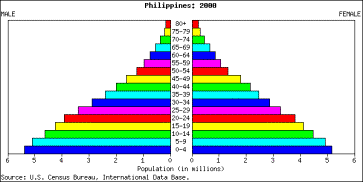
The population pyramid shown is most likely which country?

a)

Nigeria

b)

China

c)

Germany

d)

Japan

54.

The Population Pyramid shown is most likely which country?

a)

The United Arab Emirates

b)

USA

c)

Latvia

d)

Brazil

55.

The Population Pyramid shown is most likely which country?

a)

Canada

b)

Japan

c)

Zimbabwea

d)

Algeria

56.

How many countries today are in Stage one of the Demographic transition model?

a)

53 (some countries in Asia and Sub Saharan Africa)

b)

22 (some countries in Asia and Sub Saharan Africa)

c)

3 (Somalia, Bangladesh, and Afghanistan)

d)

0

57.

What is the #1 reason for migration?

a)

Better Economic opportunity

b)

Escaping violence

c)

Reunion with family

d)

desire to expand business networks

58.

Which country should consider anti natalist policies?

a)

India

b)

Japan

c)

Latvia

d)

USA

59.

Which of the following is NOT a Pronatalist policy?

a)

Free Birth Control

b)

Free child care

c)

Free College tuition

d)

Free parenting classes

60.

What is the amount of average children needed for a population to achieve ZPG?

a)

2.1 per woman

b)

1 per woman

c)

3 per woman

d)

2.5 per woman

61.

Which country in the world today has the most Internally Displaced people?

a)

China

b)

Syria

c)

Greece

d)

India

62.

Total # of deaths in a year for every 1,000 people alive in a society

a)

Crude Death Rate

b)

Crude Birth Rate

c)

Doubling Time

d)

Life Expectancy

63.

% of population growth in a year, computed as CBR minus CDR

a)

Dependency Ratio

b)

Total Fertility Rate

c)

Natural Increase Rate

d)

Crude Birth Rate

64.

Total # of deaths in a year of infants under 1 year of age for every 1,000 live births in a society

a)

Crude Death Rate

b)

Infant Mortality Rate

c)

Crude Birth Date

d)

Dependency Ratio

65.

Average # of children a woman will have in her lifetime

a)

Total Fertility Rate

b)

Crude Birth Rate

c)

Maternal Birth Rate

d)

Ecumene

66.

Bar graph that shows age and sex of population

a)

population hexagon

b)

population pyramid

c)

population pentagon

d)

population graph

67.
According to the population pyramid of this country, its population is most likely...
a)
growing slowly.
b)
growing rapidly.
c)
decreasing.
d)
not changing.
68.
VOCAB: The average number of years an individual is expected to live.
a)
life expectancy
b)
infant mortality
c)
death rate
d)
growth rate
69.
Educating women worldwide has lowered birthrates partly because
a)
educated women need to bear many children to ensure that some will survive.
b)
educated women may learn family-planning techniques.
c)
educated women contribute less to their family income.
70.

There is a preference for boys over girls in countries like China and India.

a)

True

b)

False

71.

An area where everyone shares 1 or more distinctive characteristics (Texas and their set of laws)

a)

Formal Region

b)

Functional Region

c)

Vernacular Region

72.

An area organized around a node or focal point with a strong charateristic in the center

a)

Formal Region

b)

Functional Region

c)

Vernacular Region

73.

An area people believe exist as part of their culutral idenity and their informal sense of place

answer choices

a)

Formal Region

b)

Functional Region

c)

Vernacular Region

74.
Billy thinks that in the south, everyone eats grits, eats fried chicken and watches football.  He would be creating what type of region of the south with these ideas?
a)
Formal
b)
Functional
c)
Perceptual
d)
Uniform
75.
What are lines on a globe drawn in an east-west direction and measured in degrees?
a)
longitude
b)
latitude
c)
grid
d)
equator
76.
Environment influences, but does not strictly determine, how a culture interacts with the environment.
a)
Environmental Determinism
b)
Environmental Possibilism
c)
Cultural Determinism
d)
Cultural Environmentalism
77.

What is a choropleth map?

a)

A map using different colours to represent data

b)

A map which uses differences in shading or colouring, within geographical areas to indicate the average values of a particular quantity in those areas.

c)

A map that shows different values in a country

d)

A map that shows the topography of a country

78.
What are mental maps?
a)
Maps on our minds of places we have been and places we have merely heard of.
b)
Helps us see general trends 
c)
Data collected by satellites and aircraft
d)
Compares a variety of spatial data by creating digitized representations.
79.
The choices that a society makes depend on what its members need and on what technology is available to them this is called...
a)
environmental determinism
b)
Possibilism 
c)
political ecology
d)
cultural ecology
80.
This theory explains that Europe as "superior" to the rest of the world because of the climate and location of the region is called...
a)
Environmental Determinism
b)
Possibilism
c)
Time distance decay
d)
Formal Region
81.

A geographical term which describes the effect of distance on cultural or spatial interactions is called...

a)

Distance Decay

b)

Spatial Analysis

c)

Time space compression

d)

Possibilism

82.
Site would be similar to... 
a)
Absolute location
b)
Relative location
83.
Situation is similar to... 
a)
Absolute location
b)
Relative location
84.
Pittsburgh is located at the intersection of three rivers
a)
Site
b)
Situation
85.
Tacoma is located thirty miles south of Seattle
a)
Site
b)
Situation
86.
London is located in the temperate area of Western Europe
a)
Site
b)
Situation
87.
Taiwan is located just off the southeastern tip of China
a)
Site
b)
Situation
88.
Paraguay is located in the middle of South America, between Brazil, Bolivia, and Argentina
a)
Site
b)
Situation
89.
Which projection is this?
a)
Robinson
b)
Mercator
c)
Eckert IV
d)
Goode's Homolosine
90.
Which map projection makes land near the poles seem gigantic (like Antarctica and Greenland)?
a)
Lambert
b)
Mercator
c)
Robinson
d)
Eckert IV
91.
The name of a location on Earth's surface is a
a)
site
b)
situation
c)
toponym
d)
geonym
92.
A formal region is:
a)
derived from people's sense of identity and attachment to different areas.
b)
an area that possesses one or more unifying cultural or physical traits.
c)
nonexistent in developing nations.
d)
an area unified by a specific social, cultural, or economic activity.
93.
Which is NOT an example of a functional region?
a)
the circulation area of a newspaper.
b)
the area of dominance of a local television station.
c)
the market area of a supermarket.
d)
the area dominated by a particular crop.
94.
The signal area of radio station WIVK is an example of which of kind of region?
a)
formal 
b)
functional
c)
vernacular
d)
perceptual
95.
The south is an example of which type of region?
a)
Perceptual
b)
nodal
c)
functional
d)
formal
96.
The highest natural increase rates are found in countries in which stage of the demographic transition model (DTM)?
a)
Stage 1
b)
Stage 2
c)
Stage 3
d)
Stage 4
97.
The lowest crude birth rates (CBRs) are found in countries in which stage of the DTM?
a)
Stage 1
b)
Stage 2
c)
Stage 3
d)
Stage 4
98.
The highest CDRs are found in countries in which stage of the DTM?
a)
Stage 1
b)
Stage 2
c)
Stage 3
d)
Stage 4
99.
Country X has a CBR of 40 and a CDR of 15. In what stage of the DTM is this country?
a)
Stage 1 - No growth
b)
Stage 2 - High growth
c)
Stage 3 - Moderate growth
d)
Stage 4 - Low growth
100.
For every 1,000 babies born in Mozambique this year, nearly 150 of them will die before they reach their 1st birthday. The rate of 150 deaths per 1,000 births is known as the:
a)
crude death rate.
b)
crude birth rate.
c)
total fertility rate.
d)
infant mortality rate.
101.
More developed countries (MDCs) moved from Stage 1 to Stage 2 of the DTM 200 years ago in part because of:
a)
the First Agricultural Revolution.
b)
the Industrial Revolution.
c)
people moving to cities.
d)
women choosing to enter the labor force.
102.
In which stage(s) of the demographic transition is there a high birth rate?
a)
Stage 3 only
b)
Both stages 1 & 2
c)
Stage 2 only
103.
In which stage(s) of the demographic transition is there a low, zero, or negative growth rate?
a)
Stage 3 only
b)
Both stages 1 & 4
c)
Stage 2 only
104.
People who are forced to move because of a war or natural disaster are called...
a)
Emigrants
b)
Refugees
c)
Immigrants
105.

The map shows the number of people per unit of land. Which of the following types of data are shown in the map?

a)

Arithmetic Density

b)

Physiologic Density

c)

Agricultural Density

d)

Urban Density

e)

Suburban Density

106.

Physiological population density differs from arithmetic population density in that physiological density

a)

examines only the population of cities, while arithmetic density includes the population of cities and rural areas

b)

is a measure of how density is perceived, while arithmetic density is a measure of specific density

c)

explains density in terms of people per arable square land unit, while arithmetic density explains density in terms of people per total square land unit

d)

explains the density of a single housing unit while arithmetic density explains the density of a group of houses

e)

is the number of people per housing unit, while arithmetic density is the number of people per square mile

107.

Physiological population density is viewed as a superior measure of population density for which of the following reasons?

a)

It is more reflective of population pressure on arable land.

b)

It yields the average population density.

c)

It is more reflective of the world’s largest population concentrations.

d)

It measures the average by dividing total land area by total number of people.

e)

It best reflects the percentage of a country’s population that is urbanized.

108.

Sri Lanka and Australia have about the same population. What data would help you determine which country has a higher physiological population density?

a)

The area of each country

b)

The number of farmers in each country

c)

The total fertility rate of each country

d)

The amount of arid land in each country

e)

The amount of arable land in each country

109.

The ability of a resource base to sustain a population is known as its

a)

support ratio

b)

carrying capacity

c)

subsistence limit

d)

basic employment

e)

population pressure

110.
Human beings avoid all but which of these regions?
a)
Warm lands
b)
Dry lands
c)
High lands
d)
Wet lands
111.
Relatively few people live at high elevation, but there are significant exceptions, especially in:
a)
Latin America.
b)
Eastern Europe.
c)
North America.
d)
East Asia.