wayground logo

Free Printable Worksheets

NEW

Font size

S
M
L
XL
Worksheets

South America Political & Physical Map

Total questions: 50

Worksheet time: 34mins

Name
Class
Date
1.

What is country 1?

a)

Colombia

b)

Venezuela

c)

Peru

d)

Suriname

2.

What is country 2?

a)

Colombia

b)

Venezuela

c)

Brazil

d)

Argentina

3.

What is country 6?

a)

Brazil

b)

Chile

c)

Argentina

d)

Bolivia

4.

What is country 7?

a)

Brazil

b)

Uruguay

c)

Paraguay

d)

Peru

5.

What is country 8?

a)

Brazil

b)

Argentina

c)

Chile

d)

Peru

6.

What is country 9?

a)

Paraguay

b)

Argentina

c)

Chile

d)

Peru

7.

What is country 10?

a)

Paraguay

b)

Argentina

c)

Bolivia

d)

Ecuador

8.

What is country 11?

a)

Paraguay

b)

Peru

c)

Bolivia

d)

Ecuador

9.

What is country 12?

a)

Colombia

b)

Peru

c)

Bolivia

d)

Ecuador

10.

What is country 13?

a)

Colombia

b)

Guyana

c)

Bolivia

d)

Ecuador

11.

What country is highlighted in blue?

a)

Brazil

b)

Bolivia

c)

Venezuela

d)

Colomiba

e)

Suriname

12.

What country is highlighted in blue?

a)

Uruguary

b)

Venezuela

c)

Colombia

d)

Peru

e)

Paraguay

13.

What country is highlighted in blue?

a)

Brazil

b)

Chile

c)

Argentina

d)

Bolivia

e)

Colombia

14.

What country is highlighted in blue?

a)

Brazil

b)

Argentina

c)

Chile

d)

Paraguay

e)

Suriname

15.

What country is highlighted in blue?

a)

Peru

b)

Bolivia

c)

Colombia

d)

Ecuador

e)

Paraguay

16.

What country is highlighted in blue?

a)

Ecuador

b)

Colombia

c)

Peru

d)

Venezuela

e)

Paraguay

17.

What country is highlighted in red?

a)

Paraguay

b)

Colombia

c)

French Guiana

d)

Peru

18.

What country is highlighted in red?

a)

Paraguay

b)

Uruguay

c)

Bolivia

d)

Venezuela

19.

What country is highlighted in red?

a)

Chile

b)

French Guiana

c)

Brazil

d)

Bolivia

20.

What country is highlighted in red?

a)

Venezuela

b)

Colombia

c)

Guyana

d)

Argentina

21.
What is the country and capital for #1
a)
Georgetown, Guyana
b)
Bogota, Colombia
c)
Caracas, Venezuela 
d)
Quito, Ecuador
22.
What is the country and capital for #2
a)
Georgetown, Guyana
b)
Bogota, Colombia
c)
Caracas, Venezuela 
d)
Quito, Ecuador
23.
What is the country and capital for #3
a)
Bogota, Colombia
b)
Lima Peru
c)
Quito, Ecuador
d)
Santiago, Chile
24.
What is the country and capital for #4
a)
Quito, Ecuador
b)
La Paz, Bolivia
c)
Santiago, Chile
d)
Lima, Peru
25.
What is the country and capital for #5
a)
La Paz, Bolivia
b)
Asuncion, Paraguay
c)
Santiago, Chile
d)
Lima, Peru
26.
What is the country and capital for #6
a)
La Paz, Bolivia
b)
Buenos Aires, Argentina
c)
Santiago, Chile
d)
Asuncion, Paraguay
27.
What is the country and capital for #7
a)
Lima, Peru
b)
Santiago, Chile
c)
 Buenos Aires, Argentina
d)
Asuncion, Paraguay
28.
What is the country and capital for #8
a)
 Buenos Aires, Argentina
b)
Asuncion, Paraguay
c)
Montevideo, Uruaguay
d)
Brasilia, Brazil
29.
What is the country and capital for #9
a)
 Montevideo, Uruaguay
b)
Brasilia, Brazil
c)
Buenos Aires, Argentina
d)
Asuncion, Paraguay
30.
What is the country and capital for #10
a)
Asuncion, Paraguay
b)
Brasilia, Brazil
c)
Cayenne, French Guiana
d)
Quito, Ecuador
31.

Which city is marked by the red dot?

a)

Santiago

b)

Sao Paulo

c)

Buenos Aires

d)

Rio de Janeiro

32.

Which city is marked by the red dot?

a)

Santiago

b)

Sao Paulo

c)

Buenos Aires

d)

Rio do Janeiro

33.

Which city is marked by the red dot?

a)

Asuncion

b)

Montevideo

c)

Lima

d)

Quito

34.

Which city is marked by a red dot?

a)

La Paz

b)

Quito

c)

Caracas

d)

Bogota

35.
Grassland in Brazil & Argentina
a)
Pampas
b)
Llanos
c)
Pantanal
d)
Atacama
36.
Desert region in South America.
a)
Atacama
b)
Llanos
c)
Pampas
d)
Pantanal
37.
Run along the coast from North to South
a)
Amazon River
b)
Pampas
c)
Patagonia
d)
Andes
38.
C represents what physical feature? 
a)
Pampas
b)
Altiplano
c)
Amazon River Basin (Amazon Rain Forest)
d)
Gran Chaco
39.
J represents what physical feature? 
a)
Straight of Magellan
b)
Straight of Bosporus
c)
Rio de la Plata
d)
Rio de Janeiro
40.
R represents what physical feature? 
a)
Atlantic Ocean
b)
Pacific Ocean
c)
Straight of Magellan
d)
Caribbean Sea
41.
What river is shown on the map? This is the largest river system in the world, with thousands of tributaries. Its headwaters (source) are located in the Andes mountains of Peru.
a)
Congo
b)
Amazon
c)
Pararimbo
d)
Rio Bravo
42.

What is located along the red line?

a)

Llanos

b)

Guiana Highlands

c)

Andes Mountains

d)

Cordillera Occidental

43.

What river is located along the blue line?

a)

Mississippi River

b)

Cauca river

c)

Magdalena River

d)

Orinoco River

44.

What body of water is located where the star is?

a)

Pacific Ocean

b)

Caribbean Sea

c)

Atlantic Ocean

d)

Indian Ocean

45.

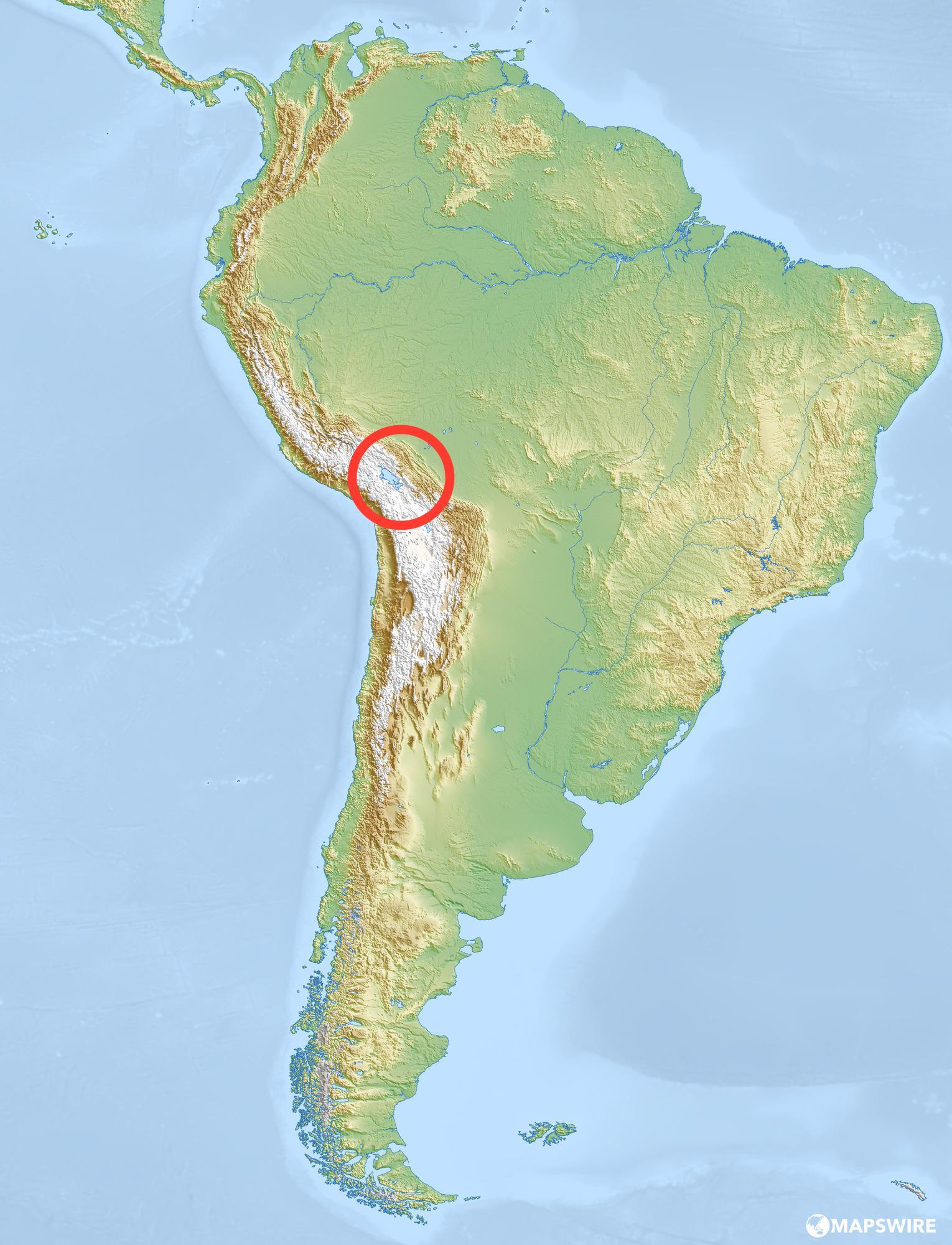
What lake is this?

a)

Lake Maracaibo

b)

Lake Titicaca

c)

Lake Superior

d)

Rio de la Plata

46.
What physical feature is highlighted on the map?
a)
Sierra Madre Mountains
b)
Atacama Desert
c)
Amazon River
d)
Panama Canal
47.
D represents what physical feature? 
a)
Brazilian Highlands
b)
Guinea Highlands
c)
Andes
d)
Altiplano
48.

What land feature is represented by letter G?

a)

PAMPAS

b)

ISTHMUS OF PANAMA

c)

BRAZILIAN HIGHLANDS

d)

CAPE HORN

49.
Q represents what physical feature? 
a)
Atlantic Ocean
b)
Pacific Ocean
c)
Caribbean Sea
d)
Rio de la Plata
50.
Name the physical feature
a)
Atacoma Desert
b)
Andes Mountain
c)
Amazon River
d)
Panama Canal