
 Worksheets
WORLD GEOGRAPHY FINAL EXAM OCT 1, 2025
Total questions: 101
Worksheet time: 1hrs 16mins
Location
Geography is...
The study of Earth and how we, the people who live there, interact with it.
The study of Earth and its atmosphere.
The study of rocks, minerals, and all physical attributes of Earth
Hemisphere is ...
The study of the earth and how we, the people who live there, interact with it.
A region created when the Earth is divided in half.
An imaginary line going across the center of the earth.
Equator is ...
An imaginary line going across the center of Earth that separates the eastern and western hemisphere.
A region created when the Earth is divided in half.
An imaginary line going across the center of Earth that separates the north and south hemisphere.
Prime Meridian is ...
An imaginary line going across the center of the earth that separates the eastern and western hemispheres.
An imaginary line going across the center of the earth that separates the north and south hemispheres.
An absolute location on the map.

What do we call the 0 degree latitude line?
Equator
Prime Meridian

What hemisphere is Europe in?
Northern
Southern
Eastern
Western

What types of lines are these?
Latitude
Longitude

What is the orange continent?
Europe
Asia
North America
Africa

What is the name of the purple continent?
South America
Australia
Antarctica
Europe
What continent do you currently live on?
United States
Texas
South America
North America
Which of the following is not a continent?
North America
Asia
China
Africa

What ocean is #4?
Atlantic Ocean
Indian Ocean
Pacific Ocean
Southern Ocean

What ocean is #3?
Indian Ocean
Arctic Ocean
Pacific Ocean
Atlantic Ocean

What physical feature is represented on the map?
The Appalachian Mountains
The Continental Divide
The Great Plains
Death Valley
Gulf of California

What major chain of mountains in South America is the world's longest at over 4,400 miles and has the highest mountains outside of Asia?
The Andes
The Rockies
The Sierra Madres
The Alps
The Himalayas

What is the major tropical rainforest in South America?
The Amazon Rainforest
The Tama Kinabalu Rainforest
The Valdivian Rainforest
The Hana Rainforest
El Yunque Rainforest

What river in South America is the world's 2nd longest and carries 20% of Earth's river water?
The Amazon River
The Orinoco River
El Rio de la Plata
The Parana River
The Paraguay River

What desert in South America is the world's driest hot desert?
The Atacama Desert
The McMurdo Dry Valleys
The Sonoran Desert
The Gobi Desert
The Sahara Desert

What traditional ranchers, similar to American Cowboys, of the Pampas are national symbols of bravery and independence in Argentina and Uruguay?
Gauchos
Farmers
Ranchers
Cowboys

What country is represented by number 2?
Colombia
Venezuala
Brazil
Paraguay
A piece of land almost surrounded by water or projecting out into a body of water.
Taiga
Alpine Mountains
Peninsula
Fjord
Separates Great Britain from France. Is a busy route for shipping transportation on it and car and train travel under it
Rhine River
Westerlies
Alpine Mountains
English Channel
Located north of Western Europe. Contains large oil & natural gas reserves and has been significant for trade and fishing.
English Channel
North Sea
Central Uplands
Mediterranean Sea
The most important body of water in Southern Europe. Stretches from Spain to Greece and is almost completely surrounded by land.
Mediterranean Sea
Mid-Atlantic Ridge
Danube River
Caspian Sea
The busiest waterway in Europe. Connects industrial regions to the North Sea and runs through the most populated region of Europe
Rivers in Western Europe
Danube River
Rhine River
Tagus River
atoll
THE (a) PENINSULA IS COMPRISED OF PORTUGAL AND SPAIN
THE (a) MOUNTAINS SEPARATE SPAIN AND FRANCE
(a) IS THE NAME OF THE AFRICAN COUNTRY THAT REPLACED SWAIZILAND
(a) IS THE LARGE ISLAND COUNTRY NE OF CANADA
THE (a) CHANNEL IS WEST OF MADAGASCAR
THE (a) SEA IS WEST OF THE ARABIAN PENINSULA
THE COUNTRY OF _______ ________ IS SOUTHEAST OF AUSTRALIA
(a)
THE COUNTRY OF ___ ____ IS SE OF GREENLAND
(a)
THEME OF GEOGRAPHY WITH PUSH AND PULL FACTORS
(a)

Which physical feature is located at the "E" on the map?
Canadian Shield
Rocky Mountains
Quebec
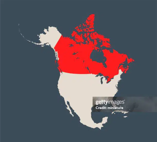
Which of the following countries is highlighted RED on the map of North America?
Canada
Germany
Mexico
United States

What is country 7?
Brazil
Uruguay
Paraguay
Peru
What is country 8?
Brazil
Argentina
Chile
Peru
What is country 9?
Paraguay
Argentina
Chile
Peru
What is country 10?
Paraguay
Argentina
Bolivia
Ecuador
What is country 11?
Paraguay
Peru
Bolivia
Ecuador
What is country 12?
Colombia
Peru
Bolivia
Ecuador

What Country is Number 8?
France
Portugal
United Kingdom
United States
What is the biggest country in Europe?
Russia
France
Italy
Germany

What country is labeled as number 7?
Italy
France
United Kingdom
Ukraine

What country is labeled by the number 5?
France
Germany
United Kingdom
Russia

What country is labeled by number 2?
Spain
Portugal
France
Ukraine

What country is located at point C on the map?
France
Germany
Russia
Ukraine

Which country is located at the letter A on the map?
South Africa
Egypt
Sudan
Nigeria

Which country is located at the letter B on the map?
Nigeria
Democratic Republic of the Congo
Kenya
Sudan

Which country is located at the letter C on the map?
Nigeria
Kenya
Sudan
Egypt

Which country is located at the letter D on the map?
Sudan
Democratic Republic of the Congo
Nigeria
South Africa

Which country is located at the letter E on the map?
Sudan
Nigeria
Kenya
Egypt

Which country is located at the letter F on the map?
South Africa
Kenya
Democratic Republic of the Congo
Nigeria

Which feature is located at the letter G on the map?
Sahel
Sahara Desert
Kalahari Desert
Savanna

Which feature is located at the letter H on the map?
Great Rift Valley
Sahel
Kalahari Desert
Tropical Rainforest

Which feature is located at the letter I on the map?
Atlas Mountains
Great Rift Valley
Tropical Rainforest
Mt. Kilimanjaro

Which feature is located at the letter J on the map?
Kalahari Desert
Savanna
Sahara Desert
Sahel
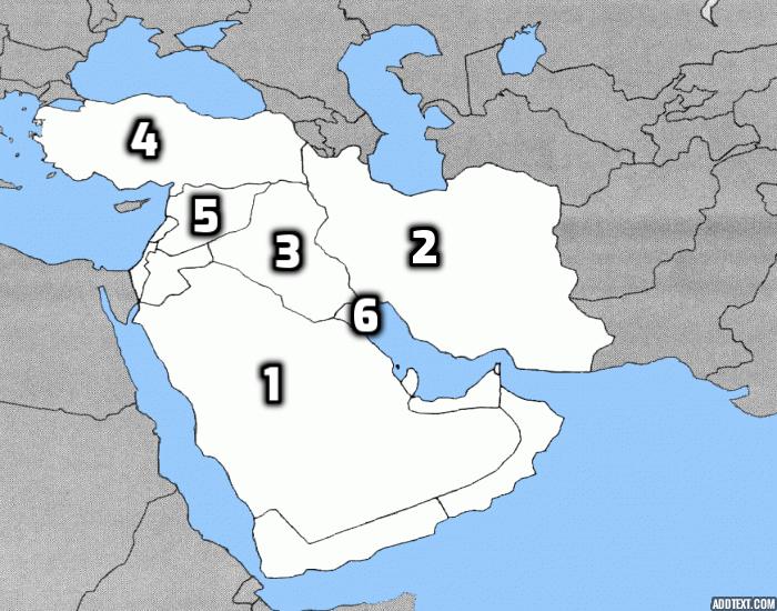
Which number represents Iran?
1
2
3
4
5
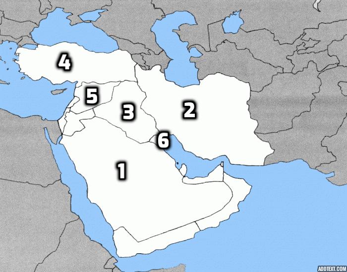
Which number represents Kuwait
3
4
5
6
1
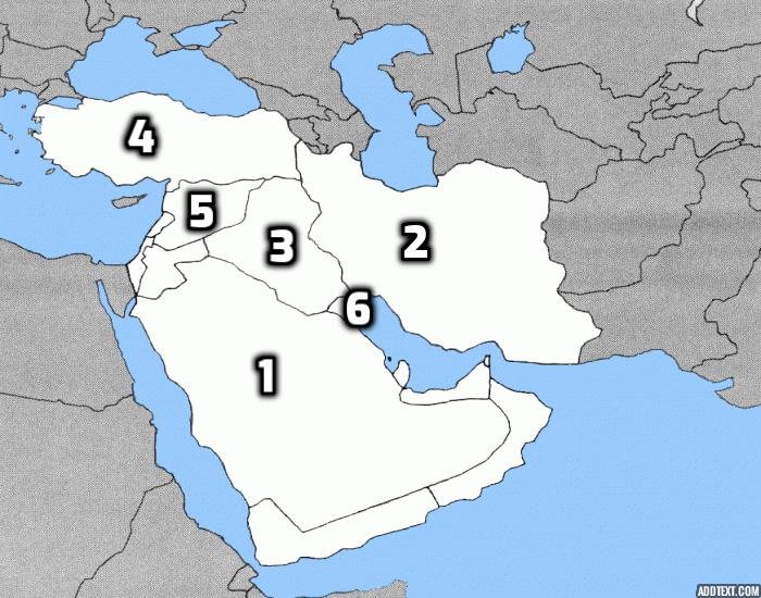
Which number represents Turkey?
2
3
4
5
6
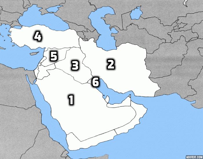
Which number represents Saudi Arabia?
1
2
3
4
5
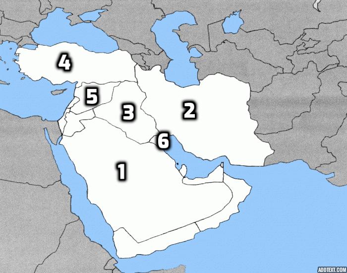
Which number represents Syria?
2
3
4
5
6
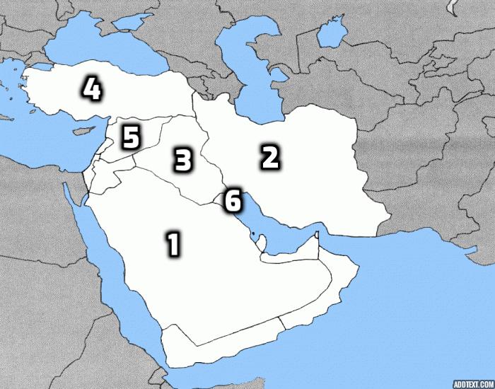
Which number represents Iraq?
1
2
3
4
5
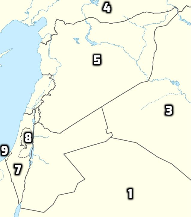
Which number represents Israel?
4
5
7
8
9

Bhutan
Vietnam
Thailand

What place is this?
Hong Kong
Singapore
Brunei
East Timor

Mongolia
Pakistan
Nepal

Bhutan
Bangladesh
Laos
Thailand

East Timor
Myanmar
Cambodia

Taiwan

Pakistan
Nepal

