
 Worksheets
Unit 2 Summative Assessment
Total questions: 138
Worksheet time: 1hrs 21mins

A thematic map that shows major natural features is a ...
physical map
social map
mountain map
dot map

What do geographers use to indicate the absolute location of any place on Earth?
Longitude and Latitude
map legend
map scale
compass rose

Which of the following would you find on a map that shows physical features?
businesses
landforms
population
vegetation
What type of natural hazard would you find in a polar climate?
hurricane
blizzard
tornadoes
Tsunamis

What month is the coldest?
October
December
January
February

A special purpose map that shows political boundaries is a ...
physical map
thematic map
cultural map
political map

A visual representation of an area is
Political map
Thematic map
Map
Physical map

In the five themes of geography what does regions mean?
the physical characteristics of an area
how and why goods get around
how people depend on their natural surroundings
places grouped together by common features

In the five themes of geography what does human environment interaction (HEI) mean?
what is it like when you get there?
where a place is on the Earth
how people depend, modify, and adapt to their natural surroundings
the way people move around the globe

What month are you LEAST LIKELY to need an umbrella?
December
June
July
January
What type of natural hazard would only be found in countries with a tropical climate that other climate zones do not have?
blizzards
volcanoes
hurricanes
earthquakes

In the five themes of geography what does location mean?
where is it and why is it there?
how ideas get around
the Rocky Mountains
what is it like when you get there?

In the five themes of geography what does place mean?
area of the world with common characteristics
North America
how people adapt their clothing to the climate.
what is like when you get there?
Which natural diasaster could be caused by earthquakes, volcanic eruptions, and plate tectonic movement?
Blizzards
Tornadoes
Hurricanes
Tsunamis

In the five themes of geography what does movement mean?
how people modify the environment
where is it and why is it there?
how people and ideas get around
what is like when you get there?

The specific location (latitude and longitude or an address) of a place is called....
relative location
movement
latitude
absolute location

A region created when the Earth is divided in half is called a ....
longitude
equator
hemisphere
region

Imaginary lines that show distances north and south of the equator are called...
longitude
prime meridian
equator
latitude
Would humans prefer to live in a mountain range or by a river?
mountain range
river


When is it the wet season?
July
December
June, July, August, September
January, February, March, April

What physical feature is located between deserts and forests?
grasslands
mountains
glaciers
rainforests


This map is an example of a . . .
Political Map
Physical Map
Population Map
Road Map

What natural feature is located on this map?
mountains
river basins
mountains
deserts
Which natural disaster can be caused by living in the grasslands and wind movment?
Tornadoes
Cyclones
Hurricanes
Tsunamis

A map showing boundaries of countries is what type of map?
Political
Physical
Population
Climate

What type of map would you use if you wanted to find the countries bordering Egypt?
Political
Physical
Road
Topographic

What type of map is this?
Thematic
Political
Resource
Economic
How have humans modified the environment (HEI) to survive natural diasaters?
Humans built basements in the Midwest to prepare for tornadoes
Humans have built warnings systems to prepare for survival of natural disasters
Some countries have building codes that people have to follow to prevent total destruction of homes
All of the above

What direction is opposite of north on a compass rose?
east
west
south
north east

What natural feature is located between deserts and forests?
glaciers
volcanoes
grasslands
deserts

_________ show the Earth as a SPHERE.
Maps
Globes
Compass rose
Which physical feature would most humans prefer to live near? (choose 2)
in the desert
by the ocean
by a lake
below sea level in a river basin

Which STATE is located at...
48°N, 100°W?

Would people prefer to live ina desert or grassland?
desert
grassland



What other physical feature is located with volcanoes?
grasslands
deserts
river basins
mountains




Imaginary line that divides Earth into the Northern and Southern hemisphere.
Equator
Prime Meridian
Axis
Lines of Longitude

What physical feature is demonstrated on this map?
mountains
rainforests
grasslands
glaciers
Which STATE is located at...
47°N, 100°W?
ND

How many hemispheres does Earth have?
4
6
2
8

What line divides the Eastern and Western hemispheres?
Prime Meridian
Equator


What hemisphere is nearest to the South Pole?
Southern
Northern
Western
Eastern

4) What is the approximate latitude and longitude of the sunken ship?
20.5° S , 70° W
20.5° S. 70° E
20.5° N, 70° W
20.5° N, 70° E

8) Which diagram is most similar to the latitude-longitude system used on Earth?


This map shows earth’s features including landscapes, rivers, mountains, oceans.
physical map
road map
climate map
topographical map

What is the purpose of the title of a map?
Shows directions on a map
Explains colors and symbols on a map
Tells what a map shows
Organizes and divides space on a map

What do physical maps show us?
Where people live in an area
Weather patterns over an extended period of time
Physical geographic features

True of False: Physical geographic maps show information about people
True
False

A map that shows different types of lands features (elevation of hills, mountains and valleys).
road map
climate map
topographical map
political map

What zone is the United States in?
Temperate
Polar
Tropical

What is the name of the climate zones at the north and south of the map?
Tropical
Polar
Temperate

Which zone has the the coldest place on earth?
Tropical
Temperate
Polar


What zone is the equator in?
Temperate
Polar
Tropical


What climate zone is the white area in the picture?
Polar zone
Temperate zone
Tropical zone

What type of map is this?
physical features of the Earth
climates of the world
countries of the world
ocean depths of the world

True or False.....A city is an example of a landform?
true
false

True or False.....A bridge is an example of a landform?
true
false

True or False.....A boat is an example of a landform?
true
false

True or False.....A mountain range is an example of a landform?
true
false

True or False.....An ocean is an example of a physical landform?
true
false

True or False.....A glacier is an example of a landform?
true
false

True or false....latitude affects climate.
true
false

True or false....being close to big bodies of water affect climate.
true
false

True or false....mountains affects climate.
true
false

True or false....ocean currents affect climate.
true
false

True or false....the ISS affects climate.
true
false

True or false....distance from sea level affects climate
true
false

True or false...altitude affects climate.
true
false

What is the absolute location of Point B?
70 degrees East,
15 degrees South
120 degrees West,
60 degrees North
15 degrees South, 70 degrees East
60 degrees North,
120 degrees West.

What is the absolute location of Point G?
60 degrees East, 60 degrees North
30 degrees South, 0 degrees
120 degrees West, 30 degrees South
60 degrees North, 60 degrees East

Name the continent that has a red circle on it.
North America
South America
Asia
Europe

The graph represents
Tropical wet climate
Precipitation
Climate
The months of the year

What month receives the least amount of precipitation?
July
June
January
August

Which climate zone is represented in this graph?
a temperate region
a polar region
a desert
a rainforest

Which climate zone do you think Nuevo Rocafuerte, Ecuador is in based on the climate graph?
tropical dry
temperate
tropical wet
polar

Which type of natural hazard is found in a temperate zone?
landslides
tornadoes
tsunamis
earthquakes

What type of climate zone would you find volcanoes?
polar
temperate
tropical
all of the above

What type of natural hazard is found in the tropical zone?
hurricanes or typhoons
earthquakes
blizzards
volcanoes

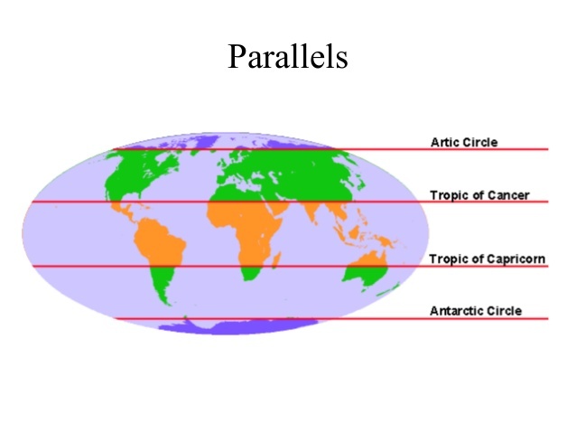
Is this line for Tropic of Cancer or the Tropic of Capricorn?
Tropic of Cancer
Tropic of Capricorn

Is this latitude line the Tropic of Cancer or the Tropic of Capricorn?
Tropic of Cancer
Tropic of Capricorn

What landform is demonstrated on the world map?
mountains
deserts
grasslands
river and river basins

What landform is represented on the world map?
deserts
mountains
glaciers
lakes
The parts of the Earth near the equator receive more sunlight than the north or south poles.
How does this impact the climate at the equator?
It makes the climate warmer.
It makes the climate rainy.
It makes the climate dry.
It makes the climate cooler.
The equator tends to contain regions with hot climates. However, the Rwenzori Mountains, which are located close to the equator, are covered in ice caps.
Why is the climate of the Rwenzori Mountains not hot?
Regions away from the ocean are cooler.
Clouds form a cold blanket over the mountains.
The mountains block radiation from the Sun.
Temperatures decrease with elevation.
Which of the following best explains why the latitude of a region influences its climate?
The latitude of a region determines its proximity to the ocean.
The latitude of a region determines the land forms present in the area.
The latitude of a region determines how much sunlight the area receives.
The latitude of a region determines its elevation above sea level.

Which of the following factors would affect the weather patterns of a region?
nearby bodies of water
altitude
latitude
all of these

What is climate?
The precipitation and temperature averaged over the course of a year
The weather for a specific day.
The weather forecast for the week.

What is altitude?
How far a place is from the equator
How far a place is from the top of a mountain
How high a place is above sea level.

How does latitude affect climate?
Latitude controls the angle of tilt for Earth’s axis.
Latitude determines the duration of daylight hours.
Latitude causes air temperatures to remain cool at higher elevations.
Latitude causes ocean currents to move in a certain direction.

Which statement describes the influence of latitude on temperature?
Latitude determines the duration of daylight.
Latitude prevents extreme heat and cold in coastal regions.
Latitude causes areas to experience cooler air at high elevations.
Latitude influences the movement of warm and cool air over land.


The rainforest gets larger every year
A continuous, directed movement of sea water which can be generated by wind, the Coriolis effect, or density
energy
wind speed
ocean current
lakes
The coldest temperatures on Earth can be found where?
In tropical rainforests
At the poles (North and South)
Close to the equator
At the equator

How far above sea level a feature is
Landforms
Landscapes
Elevation
Environment
Which climate region is in green/in between the tropics and the poles
Hot
Polar
Temperate
None of the above

The climographs above are for 2 cities that are located at similar latitudes and elevation. Which climograph BEST describes the average temperatures of a city located near a large body of water?
climograph A since it has a narrower range in temperatures
climograph B since it has abundant rainfall all year
both climographs since the two cities are at the same latitude
both climographs since the two cities are at similar elevation

Which is the desert climograph?
A
B
C
D
Which climograph has the most precipitation during the winter?
A
B
C
D
Which climograph has the most precipitation during the summer?
A
B
C
D
Which climograph has the largest degree difference between the average high and average low?
A
B
C
D
Which TWO climographs are closest to the equator (warmest)?
A
B
C
D

Which climograph do you think matches the place in the picture?


Which climograph do you think matches the place in the picture?

Why does Oregon have seasons?
Because of Earth is tilted slightly on its axis
Because we travel closer and farther away from the sun during the year

Altitude is...
the height of an object or point in relation to sea level or ground level
the distance of a place north or south of Earth's equator

Latitude is...
the height of an object or point in relation to sea level or ground level
the distance of a place north or south of Earth's equator
In the mountainous areas, climate and vegetation are affected by
Altitude or Elevation
Latitude
Longitude
The sun

Which zones are temperate zones?
Zones B and C
Zones B, C, and D
Zones, D and C
Zones D and B
A volcano is an example of a
Climate
Adapt
Natural Resource
Natural Hazard

