
 Worksheets
Impacts on Water Systems
Total questions: 76
Worksheet time: 42mins

Which Texas ecoregion would most likely have the most evidence of erosion by water?
Gulf Coast Prairies and Marshes
High Plains
Blackland Prairie
Trans Pecos

This Texas ecoregion experiences little erosion due to its rich soil with much vegetation where trees are the main plant life.
Piney Woods
Coastal Sand Plain
Rolling Plains
Prairies

Weathering can have which of the following effects in Texas?
Sediment reaching the coast
Building of mountains in west Texas
Breaking down of rocks such as at Enchanted Rock
All the above

Deposition can have which of the following effects in Texas?
Rounding or sharpening rocks
Forming sand dunes at the coast
Breaking down rocks such as at Enchanted Rock
All the above

Erosion can have which of the following effects in Texas?
Moving the coastal shore line inland
Building mountains in west Texas
Breaking down Enchanted Rock
All the above

What was the effect of overgrazing in the Trans Pecos?
Increased erosion of the soil
Change from a grassland to mountainous desert
Plant life is scarce
All the above

The landscape of the Texas Prairies has changed due to _____.
periodic fires
grazing of bison and livestock
humans making cropland/farmland
All the above

In the Plains, soil erosion due to rain is lessened by ______.
plenty of vegetation ground cover
plowing and planting along curves
efficient irrigation systems that use less water
All the above

In the Plains, droughts reduce the amount of plants causing erosion from _____ to be worse.
wind
rain
ice
gravity

The Gulf Coast Prairies and Marshes are often exposed to tropical storms originating in the Gulf of Mexico. Which of the following are effects on the coastline?
reshaped by high winds and waves
eroded and covered by water
shoreline moves landward
All the above

In the Piney Woods and Oak Wood Forest, erosion by runoff is minimal due to ______.
dense forests hold soil in place
sediments are released into runoff
fires have been going on for many years
All the above

Which of the following is a human use of the Gulf Coast Prairies that increases erosion?
grazing of bison
urban development
logging
All the above

Identify the similarity between these ecoregions: Gulf Coast Prairies & Marshes, High Plains, and Trans Pecos
Periodic fires used to maintain grass
Wind erosion affects the land
Native plants are scarce
All the above

All human development _____ the rate of erosion on the land.
decreases
increases
_________, landslides, crustal movement, or the collapse of the tops of Volcanos can form lake basins.
Erosion
Runoff
Watersheds
A shallow part of a stream that flows over
uneven ground.
stream
riffle
creek
Water flows downhill because of ____.
watershed
gravity
run off
Most streams eventually flow into a lake or ____.
estuary
river
ocean
Contains a mixture of freshwater and salt water.
estuary
watershed
lake
A large body of water that forms in a basin or hollow area surrounded by land.
stream
watershed
lake
A body of water that flows within a channel.
estuary
runoff
stream
Water that flows over Earth’s surface
run off
watershed
estuary
Estuaries contain _________, which is a mixture of freshwater and salt water.
brackish
thermocline
algae
What are small bodies of fresh water that flow into rivers?
brooks and creeks
oceans and seas
lakes and oceans


What is an algal "bloom"?
Plants bloom early down stream
Water becomes cloudy
Too much nutrient
Extremely rapid growth of algae

Bodies of water which are completely surrounded by land
lakes
tributaries
gulfs and bays
rivers

Rivers or streams that flow into larger bodies
lakes
tributaries
gulfs and bays
rivers

Large streams of water that flow along a certain path
lakes
tributaries
gulfs and bays
rivers

Large flat areas of land with very few trees
mountains
hills
plains
plateaus
peninsulas
Water flowing downslope along Earth's surface is called ___.
water fall
runoff
water shed
stream
Water is an agent of ________, carrying sediments in streams and rivers and depositing them downstream.
erosion
force
gravity
elevation
Infiltration of water into the ground depends on the number of open ________.
divide
holes
fissures
pores
All the land area that drains into a stream system is the system’s _________.
runoff
bed load
watershed
discharge
Elevated land areas called __________ separate one watershed from another.
mountains
divides
water splits
water falls
Streams _________ paths through sediment and rock, forming V-shaped stream valleys
cut
divide
suspensions
erode
Water from precipitation gathers in gullies at a stream’s ___________.
beds
headwaters
planes
banks
_____________ form in a variety of ways when depressions on land fill with water
Streams
Banks
Rivers
Lakes
______________ is a natural nutrient-enrichment process that can be accelerated when nutrients from fertilizers, detergents, or sewage are added to water.
Fertilizer
Eutrophication
Runoff
Flooding
_________ are low-lying areas that are periodically saturated with water and support specific plant species
Wetlands
Swamps
Streams
Troughs
Marshes, swamps and bogs are all types of ___________ areas.
inundated
wetland
enrichment
low
Fresh water flows downward from the tops of mountains and hills in moving bodies of water known as
ponds
oceans
rivers
lakes
Which type of water do we need to keep us alive?
Salt water
Fresh water
What makes up most of the water on Earth?
Salt water
Fresh water
Animals and humans need fresh water to survive. The amount of freshwater on Earth is....
very large
very small
Freshwater makes up how much of the Earth's water supply?
97%
75%
25%
3%

The graph above shows the chemicals and/or pollutants that are polluting our groundwater. Use this graph above to answer the following question. As the United States' population continues to grow, what is likely to be the greatest threat to our groundwater?
Fertilizer (nitrates)
Sewage
Chemical spills from petroleum
Salinity (salt)

Glaciers are made from saltwater
True
False
What makes "saltwater"?
Rain has salt in it.
Rain mixes it's salt with salt and other minerals from rocks.
Rain washes salt and other minerals from rocks, and it mixes.
ask Blayke

Water that flows over the land to streams, rivers, and lakes
Evaporation
Condensation
Precipitation
Runoff
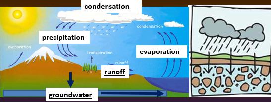
Water that is found underground in the cracks and spaces in soil, sand and rock is called:
Groundwater
River
Surface water
Snow

Which of the following are groundwater?
Lakes, ponds, creeks streams, ocean, rivers
Wells, water table, aquifers

A natural, underground area where large quantities of groundwater fill the spaces between rocks is a/an:
ocean
river
aquifer

To use water found in an aquifer, people would
build a dam
drill a well to below the water table
purify ocean water
Water collects in an aquifer because the layer below it is
permeable (water can pass through it)
impermeable (water can not pass through it)
transparent
Runoff picks up everything on the ground, including _________
fertilizer and pesticides
household chemicals and soap from washing cars
chemicals from factories
oil
all the above

Sources of water pollution include all of the following EXCEPT:
Suburban homes
Farms and golf courses
Parking lots and city streets
Water treatment plants
Factories
How can air pollution from cars and factories end up in our water??
Oil drips from cars onto roads
Air pollutants can dissolve in rain water
We use soap to wash cars
What is the top level of the water-filled spaces (saturated zone) in the ground called?
Groundwater
Reservoir
Water Table
Well

The top of the groundwater’s zone of saturation - E
Zone of Aeration
Aquifer
Surface water
Water table

The zone of percolation is where water trickles down to the aquifer and is _____________________
polluted
eroded
filtered
frozen
What keeps aquifers from percolating deeper into the Earth?
A porous layer
A permeable confining layer
A dry layer
An impermeable confining layer

Which area would describe an aquifer?
left
center
right

Which are would describe a confining layer?
right
center
left

