wayground logo

Free Printable Worksheets

Font size

S
M
L
XL
Worksheets

WORLD GEOGRAPHY FINAL EXAM REVIEW THURSDAY OCT 2, 2025

Total questions: 80

Worksheet time: 40mins

Name
Class
Date
1.
A location in relation to other locations
a)
Absolute location
b)
Formal Region
c)
Relative Location
d)
Site
2.
Factors that attract people to a place
a)
Push factors 
b)
Pull factors
c)
Forced migration
d)
Push-me-pull-you
3.

A belief in the right for each ethnic group to be a free and independent nation (term also means loyalty to nation)

a)

Nationalism

b)

Cultural diffusion

c)

Heirarchical Diffusion

d)

Sovereignty

4.
What part of a map tells you the directions?
a)
scale
b)
title
c)
compass rose
d)
key/legend
5.
On what continent do you live?
a)
South America
b)
America
c)
United States
d)
North America
6.
What is the biggest and most populated continent?
a)
Africa
b)
North America
c)
Asia
d)
Europe
7.
What is a continent?
a)
a country
b)
a great big chunk of land
c)
bodies of water
8.
If you were in the middle of Africa and you traveled north, what continent would you land on?
a)
Asia
b)
North America
c)
Antarctica
d)
Europe
9.
Which of these is not a continent?
a)
North America
b)
United States
c)
Asia
d)
Africa
10.
Philippines, China, Japan are located in which continent?
a)
Europe
b)
Asia
c)
Africa
d)
Antarctica
11.
Name the coldest place on earth
a)
Asia
b)
North America
c)
South America
d)
Antarctica
12.
This continent has three countries (Mexico, USA, Canada)
a)
South America
b)
Africa
c)
North America
d)
Asia
13.
Name the imaginary line which divides Northern and Southern hemispheres
a)
Cardinal Direction
b)
South
c)
North
d)
Equator
14.
Name the largest ocean
a)
Indian Ocean
b)
Pacific Ocean
c)
Atlantic
d)
Arctic
15.

Name the hottest place on Earth

a)

Sahara Desert, Africa

b)

El Azizia, Libya

c)

Death Valley, California

16.

Name the longest wall in the world

a)

Berlin Wall, Germany

b)

Hadrian's Wall, England

c)

Great Wall of China

17.
To locate a place on the earth, you need to look at...
a)
where the lines of latitude and longitude meet
b)
the lines of latitude only
c)
the lines of longitude only
d)
the compass rose
18.
Which continent is touched by the Prime Meridian?
a)
North America
b)
Africa
c)
Australia
d)
Asia
19.
Which letter would you find at 30oS, 30oE?
a)
A
b)
D
c)
K
d)
E
20.
What is this object known as?
a)
map symbol
b)
map key
c)
map scale
d)
compass rose
21.
What is the name of the line at 0° longitude?
a)
Equator
b)
Prime Meridian
c)
North Pole
d)
South Pole
22.
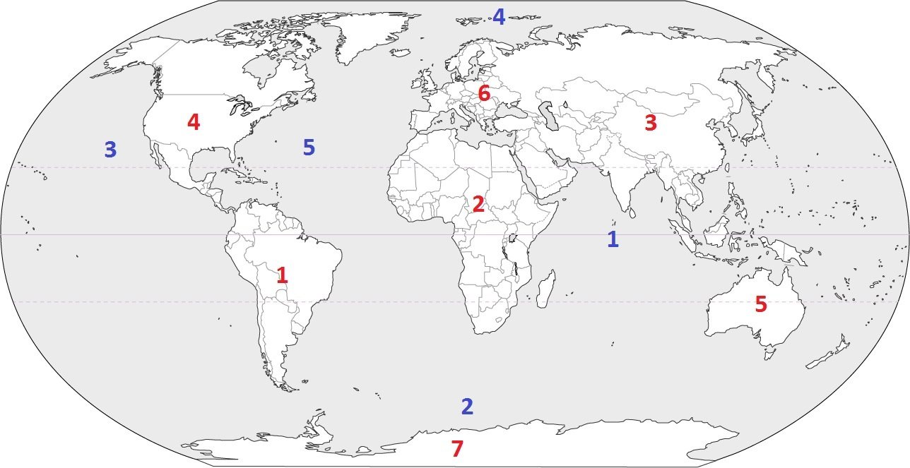
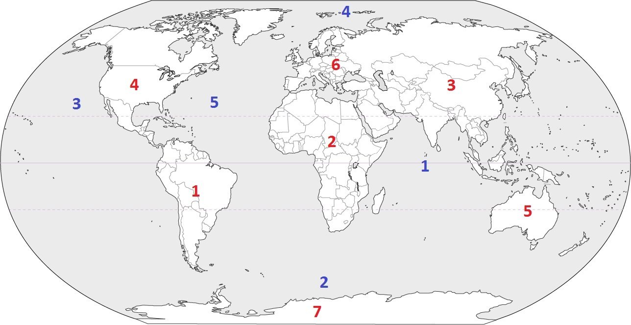
Which continent is located at #3?
a)
Australia
b)
Asia
c)
Europe
d)
South America
23.
Which continent is located at #7?
a)
Asia
b)
Africa
c)
Australia
d)
Antarctica
24.
Which continent is located at #3?
a)
Australia
b)
Asia
c)
Europe
d)
South America
25.

The Gobi Desert is located in which quadrant on the map?

a)

1

b)

2

c)

3

d)

4

26.

Which of these is a country surrounded by water on all sides?

a)

Australia

b)

Bolivia

c)

Hawaii

d)

Italy

27.

This map shows India, which is located in South Asia. Based on its location, the climate in southwestern India is MOST LIKELY

a)

desert

b)

temperate

c)

tropical monsoon

d)

tropical savannah

28.

What is the name of this national monument?

a)

Columbiana

b)

Mother Freedom

c)

the Statue of Liberty

d)

the Lady of Ellis Island

29.

What continent is this?

a)

North America

b)

South America

c)

Africa

d)

Asia

30.

What continent is this?

a)

Australia

b)

North America

c)

Europe

d)

Antarctica

31.

What is the name of this ocean?

a)

Southern Ocean

b)

Arctic Ocean

c)

Pacific Ocean

d)

Indian Ocean

32.

Which is the smallest continent?

a)

Asia

b)

Australia

c)

South America

d)

North America

33.

What oceans are on either side of the United States?

a)

Atlantic & Pacific

b)

Arctic & Southern

c)

Indian & Arctic

d)

Southern & Indian

34.

Which continent is this?

a)

Africa

b)

Europe

c)

Asia

d)

Australia

35.

What is the name of the ocean that is furthest to the north on Earth?

a)

Southern Ocean

b)

Arctic Ocean

c)

Indian Ocean

d)

Pacific Ocean

36.

What continent is this?

a)

South America

b)

Europe

c)

Antarctica

d)

Asia

37.
Which characteristics would you expect to find in a physical region?
a)
Landforms and Climate
b)
Animal Life and Language
c)
Plant Life and Religion
d)
Culture and Topography
38.
Looking out the window at school and seeing what is in nature around you is known as:
a)
Urbanization
b)
Natural Evnironment
c)
Desertification 
d)
Adapted Environment
39.
The construction of a new skyscraper in the city is classified as what?
a)
Adapted Environment
b)
Natural Environment
c)
Deforestation
d)
Human Environment
40.
Which statement is the best definition of a region?
a)
A region is an area in which people speak the same language.
b)
A region is an area that has common characteristics that distinguish it from neighboring areas.
c)
A region is an area set off from other areas by mountain ranges.
d)
A region is determined by an area's closeness to bodies of water.
41.
Why is the Middle East considered a cultural region by most geographers
a)
Its climate is warm and dry.
b)
It has an abundance of fertile valleys.
c)
It has many deserts and mountain areas.
d)
Its people share a common history and heritage.
42.
Over the past ten years, more people have been moving to the city of Cleveland.  This can best be defined by which term?
a)
Deforestation 
b)
Urbanization
c)
Desertification 
d)
Natural Environment 
43.
A farmer in the midwest over used his land and now the minerals are gone and the area has dried up, which term best describes what has happened?
a)
Urbanization 
b)
Deforestation 
c)
Desertification 
d)
Human Environment
44.
Throughout history, people have lived on mountains, in deserts, and along rivers and coastlines. What does this great variety in the areas of human settlement demonstrate? 
a)
People organize similar types of governments.
b)
People enter similar occupations in very different regions.
c)
People can adapt to different physical environments.
d)
People prefer to live away from where other people settle.
45.

40 degrees North and 55 degrees West is an example of which theme?

a)

Place

b)

Location

c)

Movement

d)

Region

e)

HEI

46.

air pollution coming from a factory smoke stack is an example of which 2 themes

a)

Place

b)

Movement

c)

Location

d)

Region

e)

H.E.I.

47.

THE MIDDLE EAST AND LATIN AMERICA SHARE COMMON FEATURES SO THEY ARE BOTH A

a)

Place

b)

Movement

c)

Location

d)

Region

e)

H.E.I

48.

Relocating from one state to another is an example of...

a)

Place

b)

Movement

c)

Location

d)

Region

49.

NORTH, SOUTH, EAST AND WEST ARE EXAMPLES OF WHAT TYPE OF DIRECTION?

a)

GRID

b)

INTERMEDIATE

c)

COMPASS

d)

CARDINAL

50.

(a)   GEOGRAPHY EXAMPLES ARE RIVERS, OCEANS, DESERTS AND MOUNTAINS

51.

A (a)   SYSTEM SHOWS WHERE LINES OF LONGITUDE AND LATITUDE INTERSECT/CROSS

52.

LATITUDE LINES ARE LOCATED ON THE (a)   AXIS

53.

LONGITUDE LINES ARE LOCATED ON THE (a)   AXIS

54.

THE EQUATOR IS AN IMAGINARY LINE THAT CIRCLES THE EARTH. TRUE OR FALSE

(a)  

55.

THE (a)   MERIDIAN SEPARATES THE EASTERN AND WESTERN HEMISPHERE

56.

THE (a)   DIVIDES THE NORTHERN AND SOUTHERN HEMISPHERE

57.

THE (a)   POLE IS LOCATED AT 90* NORTH LATITUDE

58.

THE (a)   CIRCLE IS LOCATED AT 66.5* NORTH LATITUDE

59.

THE TROPIC OF (a)   IS LOCATED AT 23.5 DEGREES SOUTH LATITUDE

60.

A (a)   MAP SHOWS COUNTRIES, BORDERS AND STATES

61.

A (a)   MAP SHOWS: LAND-FORMS AND WATERWAYS

62.

THE THEME OF GEOGRAPHY THAT ASK, WHAT IS IT LIKE THERE?

(a)  

63.

A 3D SPHERICAL REPRESENTATION OF THE EARTH

(a)  

64.

A (a)   KEY/LEGEND CONTAINS ALL THE INFORMATION ABOUT THE MAP AND WHAT THE SYMBOLS REPRESENT

65.

A MAP (a)   IS USED TO DETERMINE DISTANCE FROM ONE POINT TO ANOTHER POINT

66.

(a)   FARMING IS WHERE ONE GROWS ENOUGH TO FEED THEIR FAMILY

67.

(a)   FARMING IS WHERE THE GROWER PRODUCES ENOUGH CROPS TO SELL AND MAKE A PROFIT

68.

SMALLER RIVERS CONNECTING TO LARGER RIVERS ARE CALLED (a)  

69.

THE POINT WHERE A RIVER EMPTIES INTO AN OCEAN SEA OR GULF IS CALLED THE (a)  

70.

A BODY OF LAND SURROUNDED BY WATER

(a)  

71.

A BODY OF WATER COMPLETELY SURROUNDED BY LAND

(a)  

72.

BODY OF LAND SURROUNDED BY WATER ON 3 SIDES

(a)  

73.

LOW LAND BETWEEN TWO MOUNTAINS/HIGH PLACES

(a)  

74.

A TYPE OF CLIMATE/AREA THAT RECEIVES LESS THAN 10 INCHES OF RAIN PER YEAR

(a)  

75.

THE PROCESS OF AN AREA SLOWLY CHANGING/TRANSFORMING INTO A DESERT IS CALLED

(a)  

76.

A (a)   IS A MAN-MADE STRUCTURE BUILT TO PREVENT FLOODING AND CONTROL/REGULATE FLOW OF POWER

77.

A (a)   IS A MAN-MADE CREATED WATER-WAY PATH DESIGNED TO INCREASE TRADE, TRAVEL AND SHORT CUTS

78.

(a)   IS A THEME OF GEOGRAPHY THAT ASKS THE QUESTION "WHERE IS IT?"

79.

NAME THE WATER-WAY THAT BORDERS: FLORIDA, MISSISSIPPI, LOUISIANA, ALABAMA AND TEXAS

(a)  

80.

THE RIO GRANDE RIVER BORDERS THE COUNTRY OF _____________ AND THE STATE OF _______________

(a)