
 Worksheets
S6 Geography 3rd Term Exam Revision
Total questions: 50
Worksheet time: 19mins
________________ rainfall occurs when the energy of the sun heats the surface of the Earth, causing water to evaporate to form water vapour. When the land heats up, it warms the air above it. This causes the air to expand and rise. As the air rises, it cools and condenses.
Convectional
Frontal
Relief
Orographic
Factors affecting precipitation include...
moisture availability
water-holding capacity of the air
force of gravity near the earth surface
air-rising mechanism
High temperatures encourage (a) , which is the process by which water is transferred from the land to the atmosphere by evaporation from the soil and other surfaces and by transpiration from plants.

The climate graph below represents the (a) climate.

The climate graph below represents the (a) climate.

The climate graph below represents the (a) climate.

Which climate does the climate graph represent?
Cold Climate
Temperate Climate
Tropical Climate
Semi-arid Climate
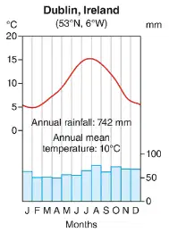
Which climate does the climate graph represent?
Cold Climate
Marine West Coast Climate
Tropical Climate
Semi-arid Climate

Which climate does the climate graph represent?
Temperate Climate
Cold Climate
Tropical Climate
Semi-arid Climate

Which climate does the climate graph represent?
Temperate Climate
Cold Climate
Tropical Climate
Semi-arid Climate

Which climate does the climate graph represent?
Temperate Climate
Cold Climate
Tropical Climate
Semi-arid Climate

Which climate does the climate graph represent?
Polar Climate
Tundra Climate
Arid Climate
Arctic Climate
Equatorial Climate: temperatures are persistently __________ throughout the year, and the annual range of temperature is _________.
high, large
high, small
low, large
low, small
Near the Equator, surface convergence of westerlies leads to strong convection, which forms dense clouds and torrential showers. As a result, there is rainfall all year round.
True
False
The seasonal rainfall pattern of tropical climate is mainly caused by the shifting of the (a) (abbreviation) following the overhead sun.
Arid climate is caused by the __________________ of air associated with ___________ pressure belts, along with ___________ distances from the sea.
rising, low, short
rising, high, short
subsidence, low, long
subsidence, high, long
Temperate grasslands such as Prairie in North America, Steppe in Eurasia and Pampas in South America are examples of vegetation that are common in __________- latitudes.
low
mid
high
In the coastal regions, temperatures and rainfall are not regulated by oceans.
True
False
Temperate ______________ forests are mainly dominated by broadleaved trees that have their leaves changed in colour in autumn, and lose their leaves in winter every year.
coniferous
deciduous
evergreen
Which THREE of the following best describes the Mediterranean Climate?
In summer, the subtropical high shifts polewards. Air descends and brings stable weather.
In winter, the subpolar low and subtropical high shifts towards the equator. Under westerlies, relief and frontal rain are common.
Precipitation mainly falls in winter.
Both the annual mean temperature and the annual range of temperature are high.
With long, dark and severe winters in Tundra, the subsoil is permanently frozen and is known as (a) .
The (a) slope of a high mountain is arid because air sinks on this slope, resulting in a rain shadow with little rainfall.
Condensation occurs when the air is cooled to (a) point.
Precipitation increases with ____________ distance from the sea.
increasing
decreasing
Places with ____________ prevailing winds have little or scare rainfall throughout the year.
onshore
offshore
Air tends to ___________ in low-pressure areas.
rise
sink
Select all the low pressure belts:
Equatorial
Subtropical
Subpolar
Polar
Deserts along the ___________ coasts of continents are often colder than those at similar latitudes, and they are humid with fog or low clouds due to the effects of cold currents.
east
west
north
south
(a) forests are composed primarily of cone-bearing trees with needle-like leaves and stay green all year long.
________ climate is found near the subtropical high pressure belt and inland areas of the mid-latitudes. It has a large diurnal and annual range of temperature.
Temperate
Tropical wet and dry
Arid
Mediterranean
(a) rain is the most common in winter in Mediterranean climate.

Brazil
Canada
Mexico
USA

India
China
Vietnam
Russia

Australia
India
Indonesia
Vietnam

USA
Mexico
Canada
What is another name for orographic precipitation?
Relief precipitation
Cyclonic precipitation
Frontal precipitation
Convectional precipitation
Which type of precipitation is most common in coastal regions with a mountain range?
Cyclonic precipitation
Frontal precipitation
Convectional precipitation
Orographic precipitation
What happens when a warm moist air mass meets a cold dry one?
The warm air sinks and warms
The cold air rises and cools
The warm air rises and cools
The cold air sinks and warms
Which type of precipitation is more common in tropical regions?
Orographic precipitation
Cyclonic precipitation
Convectional precipitation
Frontal precipitation

The image illustrates frontal rainfall.
True
False

Which type of rainfall is seen in the image?
Convectional
Relief
Frontal

Which type of rainfall is seen in the image?
Relief
Convectional
Frontal
Precipitation
The lithosphere includes:
all the rocks and minerals found in Earth’s ground
all the water on Earth
all the air that surrounds Earth
all the living things on Earth

What is the biosphere?
all the air and gases on the planet
made up of living things
the non-living soil, rocks, and minerals of the Earth
the rivers, lakes, and oceans of the Earth

What is the hydrosphere?
all the air and gases on the planet
made up of living things
the non-living soil, rocks, and minerals of the Earth
the rivers, lakes, and oceans of the Earth

What is the atmosphere?
all the air and gases on the planet
made up of living things
the non-living soil, rocks, and minerals of the Earth
the rivers, lakes, and oceans of the Earth

When lake water evaporates, the interaction is between the __________ and the _____________.
atmosphere and hydrosphere
biosphere and lithosphere
hydrosphere and lithosphere
atmosphere and biosphere

When a river current erodes the banks of the river, the interaction is between the __________ and the _____________.
atmosphere and hydrosphere
biosphere and lithosphere
hydrosphere and lithosphere
atmosphere and biosphere
refers to the state of the air when the relative humidity of air reaches 100%, or when the amount of water vapour in the air is at its maximum capacity.
(a)
High temperatures encourage (a) , which is the process by which water is transferred from the land to the atmosphere by evaporation from the soil and other surfaces and by transpiration from plants.

