
 Worksheets
Topographic Maps
Total questions: 21
Worksheet time: 22mins
Name
Class
Date
1.
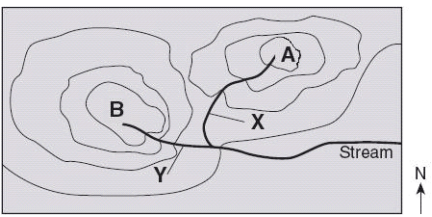
Which direction is the stream flowing?
a)
northward
b)
southward
c)
westward
d)
eastward
2.
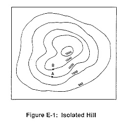
What is the contour interval on this map?
a)
100
b)
10
c)
15
d)
20
3.

How many peaks are on the map? (hill tops)
a)
4
b)
3
c)
2
d)
1
4.
It is steep on a topographic map where __________.
a)
lines are closest together
b)
a river flows into a lake
c)
contours bend
d)
contours are far apart
5.

What feature is at the arrow?
a)
volcano
b)
mountain
c)
cliff
d)
river
6.

Determine the contour interval:
a)
5 m
b)
10 m
c)
15 m
d)
20 m
7.

What are the darker lines called?
a)
roads
b)
index contour
c)
contour interval
d)
waves
8.

What is the contour interval of the topographic map below?
a)
400 m
b)
200 m
c)
100 m
d)
80 m
9.
What do contour lines that are farther apart represent?
a)
waterfall
b)
steep area
c)
gentle slope
d)
river
10.

If we were in a plane, Path B --> C is about the same distance as path E --> N. But, which path is the easier walk?
a)
B --> C is the easier walk
b)
E --> N is the easier walk
c)
B --> C and E --> N are the same walking distance
11.

What is the highest elevation on this map?
a)
Over 320 meters
b)
Over 450 meters
c)
Over 220 meters
d)
Over 380 meters
12.

What is the elevation of the peak of the small island on the left side?
a)
About 20 meters
b)
About 40 meters
c)
About 60 meters
d)
About 200 meters
13.

Which topographic map matches formation C?
a)
1
b)
2
c)
3
d)
4
14.
On a topographic map of a mountain, you walk a longer distance to get to the top when the contour lines are
a)
spread out
b)
close together
c)
going down
d)
going up
15.
The height above sea level is called
a)
topographic
b)
contour
c)
elevation
d)
depth
16.

What is the elevation of point B? (Contour interval is 100m)
a)
800 ft
b)
850 ft
c)
900 ft
d)
1000 ft
17.
What is the elevation at sea level?
a)
0
b)
100m
c)
20m
d)
3000m
18.
What does a topographical map show?
A.
a)
Shows the water features of an area
b)
B. Shows the elevation, slope and relief of a land
c)
C. Shows roads and highways
d)
D. Shows the population of an area'S oil reserves
19.

The topographic map shows the location of a park ranger at Point X when a message is received that an injured hiker needs help at Point Z. Which of these is closest to the difference in elevation between the locations of the ranger and the injured hiker?
a)
2,050 m
b)
450 m
c)
910 m
d)
3,650 m
20.
The difference between the highest and lowest point is ...
a)
relief
b)
elevation
c)
plain
21.
...... describes the shape of a land.
a)
Mountain
b)
Surface
c)
Topography
100 %

