
 Worksheets
Earth History, Structure, & Hazards (E.8.9A.1-7 & E.8.9B.1-3)
Total questions: 75
Worksheet time: 2hrs 43mins


Process by which new ocean crust forms.
Seafloor spreading
Continental drift
Mid-ocean ridge
Rift
Sea-floor spreading begins at the
Deep ocean trench
Mid-ocean ridge
Continent's edge
What were 2 kinds of evidence were used to prove that the seafloor spread?
rock formations, WWII shipwrecks
magnetic seafloor stripes, WWII ship logs
magnetic seafloor stripes, age of rocks
Why does oceanic crust sink below the continental crust during subduction
oceanic crust is less dense
oceanic crust is more dense
oceanic crust is older
oceanic crust is warmer
What are the names of ALL parts of the geologic time scale in correct order from broadest to narrowest?
era, period, eon
eon, era, period, epoch
era, eon, epoch, period
eon, era, epoch, period

What type of event usually marks the end of an Era
A Mass Extinction
A Quinceanera
An earthquake
A Volcanic Eruption
The Law of Superposition states that
the older layers of rock are at the bottom
the older layer of rock are at the top
the younger layer of rock is at the bottom
the younger layer of rock is in the middle

If we want to figure out the age of layers from two different locations what would be the best way to do so?
We can compare the fossils found in the layers of one location to the fossils in the other location
We can use the law of superposition to figure out the rate of layer formation
Radioactive dating to compare the age of the rocks in the layers
Compare the number of layers in each location
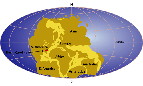
Why may fossil of the same organism be found on different continents?
Because the continents were once together
Similar fossils should not be found on different continents
Because fossils change over time
Because of the Evolution of the Earth


If a country tries to mitigate the impact of a hazard, it
develops strategies and plans to reduce the severity of the hazard.
reduces the economic impact of the hazard.
develops strategies to protect natural vegetation from the hazard.
reduces the social impact of a hazard.

The movement of the tectonic plates is caused by
the rotation of the Earth.
convection currents in the Asthenosphere
the gravity of the iron-nickel core.
the Moho discontinuity.
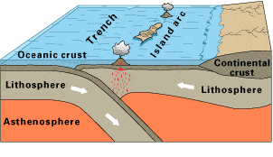
Observe this diagram of a plate boundary. One statement BEST describes what is happening. It is that
the oceanic crust is melting.
the denser ceanic crust is subducting under the less dense oceanic crust
volcanic islands are forming.
the tectonic plates are moving away from each other.


Most geologists think that the movement of Earth’s plates is caused by _______
convection.
continental drift.
subduction.
conduction.
A place where two plates slip past each other, moving in opposite directions, is known as a _______
transform boundary
divergent boundary.
convergent boundary.
rift valley.

The place where two plates come together is known as a _______
transform boundary.
divergent boundary.
convergent boundary.
rift valley.

Below is a picture of sea-floor spreading. How are the ocean crusts moving?
Converging
Diverging
Sliding
No movement
The San Andreas Fault in California is known as an active earthquake area. What type of
boundary is it?
Converging
Diverging
Transform
Sea Floor Spreading
The movement of the tectonic plates is caused by
the rotation of the Earth.
convection currents in the Asthenosphere
the gravity of the iron-nickel core.
the Moho discontinuity.
Observe this diagram of a plate boundary. One statement BEST describes what is happening. It is that
the oceanic crust is melting.
the denser ceanic crust is subducting under the less dense oceanic crust
volcanic islands are forming.
the tectonic plates are moving away from each other.
What type of plate boundary lies on the west coast of South America?
Convergent
Divergent
Transform
Uncertain
Which two mantle hot spots are located at midocean ridges?
Iceland and Yellowstone
Galapagos and Tasman
St. Helena and Hawaii
Easter Island and Bouvet
Which type of tectonic plate boundary is found between the South American Plate and the Scotia Plate?
transform
convergent
divergent
complex or uncertain
Crustal formation, which may cause the widening of an ocean, is most likely occurring at the boundary between the
African Plate and the Eurasian Plate
Pacific Plate and the Philippine Plate
Indian-Australian Plate and the Antarctic Plate
South American Plate and the North American Plate
Trenches can be produced at contact zones between tectonic plates. The boundary between the following plates is an example of that:
South American and African
Indian-Australian and Pacific
Eurasian and North American
Pacific and Antarctic
What plate does New York lie on?
(a)

What type of process most likely created the mountain chain seen here?
Volcanic eruptions created the mountains over millions of years.
Tectonic plates pushed together forcing one plate under the other and then pushing the land upward.
Earthquakes broke the earth into pieces and parts of it fell into cracks between faults.
A river flowed through the land and created the valleys between the mountains making them appear taller.

A seismograph tells us what information about an earthquake?
How deep within the earth the earthquake occurred.
How far a tsunami will travel
How much damage the earthquake caused
How strong the earthquake is

What are the primary purposes for the use of dams?
To prevent droughts and reverse the flow of a river.
To keep unwanted marine organisms from moving down stream.
To control floodwaters and store water for people to use.
To make lakes so that people have a place to go fish.

The picture here shows a landslide. What can you infer from the picture?
Landslides are a destructive process that break apart the surface of the earth.
Landslides are a constructive process that build new mountains and dams on the surface of the earth.
Landslides are caused by volcanic eruptions,
Landslides are helpful to road crews.

Sand dunes can be viewed in the picture. What is the best way to simulate the formation of sand dunes?
Use a hair dryer to blow sand into piles showing how wind can deposit sand in new locations.
Use ice to move sand from one place to another the way that a glacier would on the earth's surface.
Use water and sand to show how water can move sand from one place to another through the process of erosion.
Use sand and a shaky table to show how earthquakes can move parts of the earths surface.
How can plants cause the weathering of rocks?
roots can grow into or near rocks causing the rocks to break down over a period of time.
plants can chemically break down rocks using photosynthesis
plant roots can use the rocks as a source of nutrients and break them down over time
plants can release water vapor into the air that causes the rocks to break down over time.
What is something that humans can do to control water in areas that regularly experience floods?
Dig wells to hold excess water.
allow erosion to occur in order to make larger deltas
build and use storm drains to move water to other areas.
use a seismograph to see how much water is coming so that we can prepare for it's arrival.
Earthquakes can cause which of the following
Landslides
Aftershocks
Tsunamis
All of the other answers here are correct.
What does it mean to restore a beach?
Replace the sand on the beach.
Move the sand from one beach to another
Building a wall on the beach to keep wind and water away
Leave all of the seashells and other items on the beach instead of picking them up.
Richter scales are used to measure
the size of a volcanic eruptions
the strength of a tornado
the magnitude of an earthquake
the power of flood waters flowing over land
Which of the following landforms are created over a long period of time?
Mountains and Canyons
Landslides and Sand dunes
Ponds and Mountains
Volcanic eruptions
What is the name of a place where tectonic plates meet and show movement?
Glacier
The core
Fault
Deposition

