
 Worksheets
Maps of India
Total questions: 135
Worksheet time: 1hrs 3mins


What is located here?
Caspian Sea
Arabian Sea
Indian Ocean
Bay of Bengal

What is located here?
Iran
Afghanistan
Pakistan
Bhutan

What is located here?
Sri Lanka
Maldives
Bangladesh
Bhutan

What is located here?
Nepal
Bhutan
Bangladesh
Myanmar
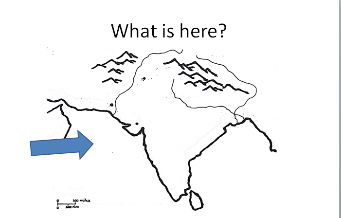
Which body of water is here?
Indian Ocean
Caspian Sea
Arabian Sea
Bay of Bengal
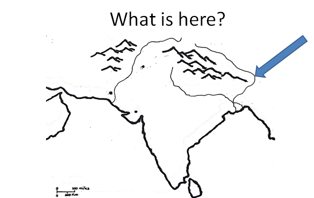
Which body of water is here?
Indus River
Ganges River
Brahmaputra River
Nile
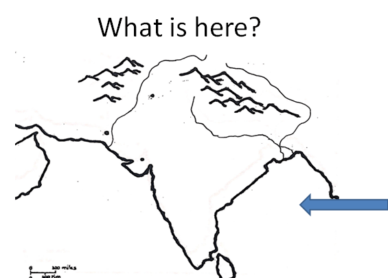
Which body of water is here?
Indian Ocean
Indus River
Arabian Sea
Bay of Bengal
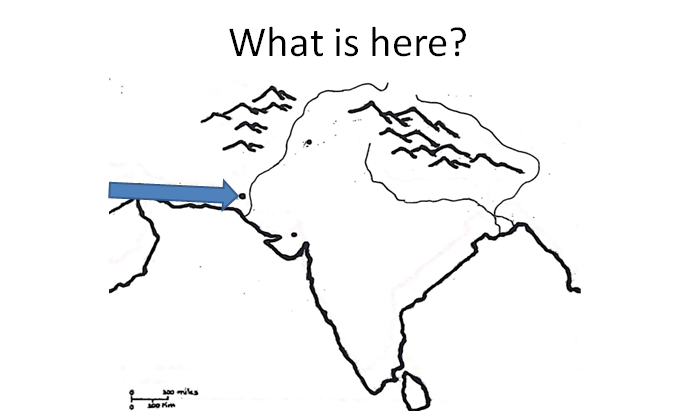
What city is here?
Mohenjo-Daro
Harappa
Lothal
Thebes
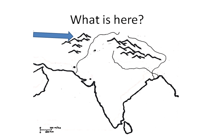
What is here?
Hindu Kush
Taurus Mountains
Zagros Mountains
Himalayas
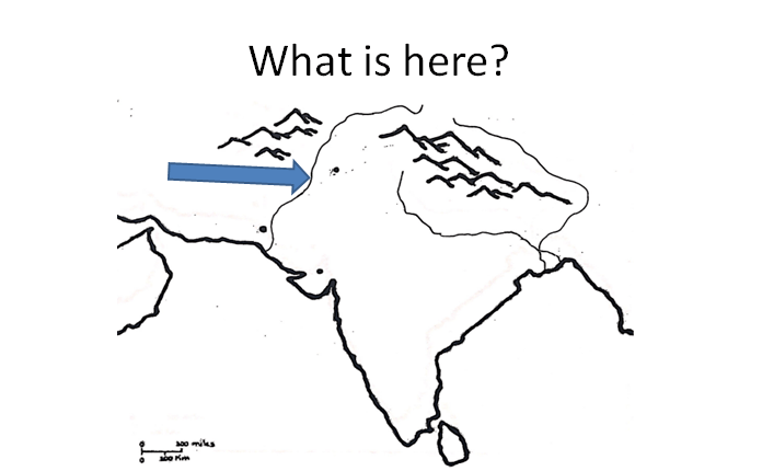
What body of water is here?
Indus River
Ganges River
Brahmaputra River
Tigris River
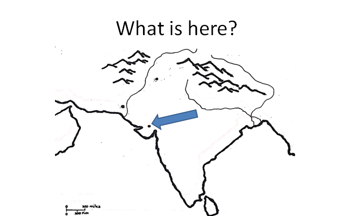
What city is here?
Mohenjo-Daro
Harappa
Lothal
Cairo
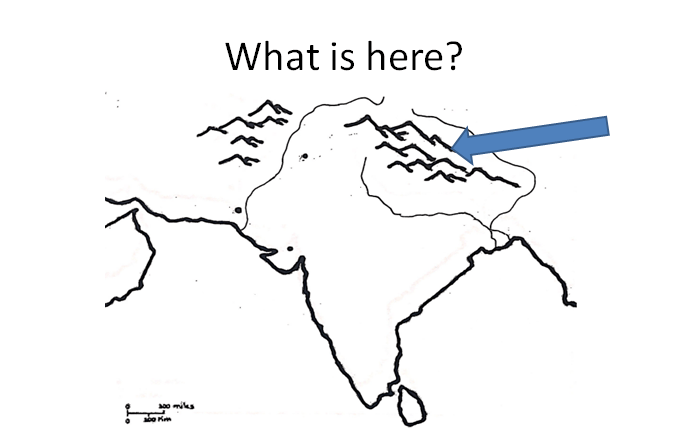
What is here?
Zagros Mountains
Hindu Lush
Himalayas
Taurus Mountains
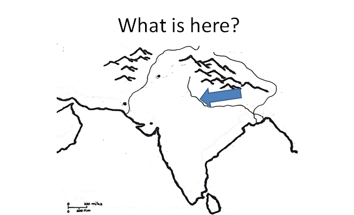
What body of water is here?
Indus River
Ganges River
Brahmaputra River
Euphrates
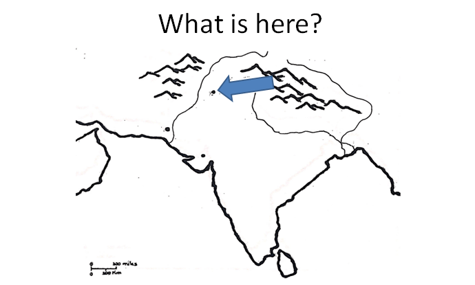
What city is here?
Mohenjo-Daro
Harappa
Lothal
Memphis
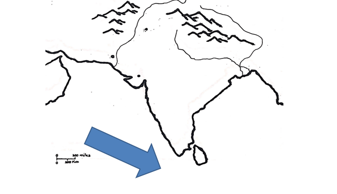
What body of water is here?
Black Sea
Bay of Bengal
Arabian Sea
Indian Ocean

What is 1 on this map?
Himalaya Mountains
Hindu Kush Mountains
Rocky Mountains
Tibetan Plateau

What is 2 on this map?
Himalaya Mountains
Hindu Kush Mountains
Rocky Mountains
Indus Plain

What is 3 on the map?
Indus Plain
Ganges River
Indus River
Nile River

What is 4 on the map?
Indus River
Nile River
Ganges Plain
Ganges River

What is 5 on the map?
Indian Ocean
Bay of Bengal
Arabian Sea
Mediterranean Sea

What is 6 on the map?
Indian Ocean
Arabian Sea
Bay of Bengal
Bay of Bismark

What is 7 on the map?
Bay of Bengal
Indian Ocean
Arabian Sea
Mediterranean Sea

What is 8 on the map?
Magadha
Memphis
Harappa
Mohenjo-Daro

What is 9 on the map?
Harappa
Mohenjo-Daro
Indus Plain
Hindu Kush

What is located here?
Pakistan
Afghanistan
Iran
Iraq

What is located here?
China
Pakistan
India
Sri Lanka
What is located here?
Caspian Sea
Arabian Sea
Indian Ocean
Bay of Bengal

What is located here?
Maldives
Sri Lanka
India
Bangladesh

What is located here?
China
India
Pakistan
Afghanistan
What is located here?
Iran
Afghanistan
Pakistan
Bhutan

What is located here?
Nepal
Bhutan
Bangladesh
Myanmar
What is located here?
Sri Lanka
Maldives
Bangladesh
Bhutan
What is located here?
Nepal
Bhutan
Bangladesh
Myanmar

What is located here/
Iran
Afghanistan
Pakistan
India

What is located here?
Arabian Sea
Indian Ocean
Bay of Bengal
Persian Gulf

What is located here?
Arabian Sea
Bay of Bengal
Pacific Ocean
Indian Ocean

What is located here?
Bhutan
Myanmar
Bangladesh
Sri Lanka

What is located here?
Nepal
Bhutan
Bangladesh
Myanmar
What is 1 on this map?
Himalaya Mountains
Hindu Kush Mountains
Rocky Mountains
Tibetan Plateau
What is 2 on this map?
Himalaya Mountains
Hindu Kush Mountains
Rocky Mountains
Indus Plain
What is 3 on the map?
Indus Plain
Ganges River
Indus River
Nile River
What is 4 on the map?
Indus River
Nile River
Ganges Plain
Ganges River
What is 5 on the map?
Indian Ocean
Bay of Bengal
Arabian Sea
Mediterranean Sea
What is 6 on the map?
Indian Ocean
Arabian Sea
Bay of Bengal
Bay of Bismark
What is 7 on the map?
Bay of Bengal
Indian Ocean
Arabian Sea
Mediterranean Sea
What is 8 on the map?
Magadha
Memphis
Harappa
Mohenjo-Daro
What is 9 on the map?
Harappa
Mohenjo-Daro
Indus Plain
Hindu Kush


India is a large landmass that is like a continent, only smaller. Which term best describes the region of India?
Subcontinent
Monsoon
Natural Barrier
Island

Which of the numbers on the map represent the location of India in the Eastern Hemisphere?
1
2
3
4

India is part of which region on the continent of Asia?
East Asia
Southeast Asia
South Asia
Southwest Asia

India's climate is divided into two seasons. Which term best describes India's climate?
Arid (Dry and hot with little precipitation)
Semiarid (Hot and mostly dry through the year)
Continental Climate (Hot summers and Cold winters)
Monsoon (Wet Season and Dry Season)

Which river contributed to the excellent agriculture of early Indian Civilizations?
Nile River
Tigris and Euphrates Rivers
Indus River
Huang Ho River

Which number on the map represents the location of the Indus River in India?
1
2
3
4
5
Which number on the map represents the location of the Himalaya Mountains in India?
1
2
3
4
5
Which number on the map represents the location of the Indian Ocean?
1
2
3
5
6
Which number on the map represents the location of the Bay of Bengal?
1
2
4
5
6
Which number on the map represents the location of the Hindu-Kush Mountains?
1
2
3
4
5
Which number on the map represents the location of the Arabian Sea?
1
2
4
5
6

Which choice describes a benefit of Summer Monsoons in India?
Provides water for agriculture
Severe flooding of cities
Causes landslides
Makes transportation difficult
Which choice describes a disadvantage of Summer Monsoons in India?
Provides water for agriculture
Causes severe flooding of cities
Supplies water for drinking
Supplies water for bathing

The Hindu-Kush and Himalaya Mountains make migration into and out of India difficult, isolating the subcontinent from the rest of Asia. Which term best describes these mountain ranges in terms of human migration?
Natural Barriers
Political Factors
Economic Factors
Subcontinents

Name the latitude which passes through the middle of India
Tropic of cancer
Tropic if capricorn
Arctic circle
821/2' degree latitude

Identify the marked place in India map
Indira Point
K2
Indiracol
Kangra

Name the place marked in the map
Indiracol
Port Blair
Lakshadweep
Indira Point

Name the coast marked in map
Malabar Coast
Coromandel Coast
Circar coast
Konkan Coast

Identify the coast marked in the map
Coromandel Coast
Malabar Coast
Konkan Coast
Circar Coast

Name the Coast marked in the map
Coromandel Coast
Malabar Coast
Konkan Coast
Circar Coast

Identify the Coast marked in the map
Konkan Coast
Coromandel Coast
Circar Coast
Malabar Coast

Name the place marked in the map
Kanyakumari
Palk Strait
Gulf of mannar
Gulf of kutch

Identify the place marked in the map
Kanyakumari
Gulf of mannar
Gulf of kutch
Palk Strait

Identify the marked region in the map
Eastern Ghats
Western Ghats
Aravalli Mountains
Nilgiris

Identify the region marked in the map
Eastern Ghats
Western Ghats
Aravalli Mountains
Nilgiris

Identify the river valley project marked in the map
Hirakud Project
Bhakra Nangal Project
Kosi Project
Rihand Project

Identify the river valley project marked in the map
Hirakud Project
Damodar Project
Gandak Project
Chambal Project

Name the river valley project marked in the map
Upper Krishna Project
Narmada Project
Nagarjuna Sagar Project
Chambal Project

Name the river valley project marked in the map
Hirakud Project
Tungabhadra Project
Gandak Project
Kosi Project
Identify the place marked in the map
Kanyakumari
Gulf of mannar
Gulf of kutch
Palk Strait

Name Port Marked in the map
Mangalore Port
Kochi Port
Mumbai Port
Kanda Port

Identify the port marked in the map Port
New Mangalore Port
Marmagoa Port
Kochi Port
Tutukudi Port

Name the Port marked in the map
Kolkata Port
Haldia Port
Vishakapatnam Port
Paradeep Port

Observe the India map and identify line which passes through it.
Tropic of cancer
Tropic of capricorn
Antarctic circle
82 1/2 degree east longitude
Name the latitude which passes through the middle of India
Tropic of cancer
Tropic if capricorn
Arctic circle
821/2' degree latitude
Identify the marked place in India map
Indira Point
K2
Indiracol
Kangra
Name the place marked in the map
Indiracol
Port Blair
Lakshadweep
Indira Point
Name the coast marked in map
Malabar Coast
Coromandel Coast
Circar coast
Konkan Coast
Identify the coast marked in the map
Coromandel Coast
Malabar Coast
Konkan Coast
Circar Coast
Name the Coast marked in the map
Coromandel Coast
Malabar Coast
Konkan Coast
Circar Coast
Identify the Coast marked in the map
Konkan Coast
Coromandel Coast
Circar Coast
Malabar Coast
Name the place marked in the map
Kanyakumari
Palk Strait
Gulf of mannar
Gulf of kutch
Identify the place marked in the map
Kanyakumari
Gulf of mannar
Gulf of kutch
Palk Strait
Identify the marked region in the map
Eastern Ghats
Western Ghats
Aravalli Mountains
Nilgiris
Identify the region marked in the map
Eastern Ghats
Western Ghats
Aravalli Mountains
Nilgiris
Identify the river valley project marked in the map
Hirakud Project
Bhakra Nangal Project
Kosi Project
Rihand Project
Identify the river valley project marked in the map
Hirakud Project
Damodar Project
Gandak Project
Chambal Project
Name the river valley project marked in the map
Upper Krishna Project
Narmada Project
Nagarjuna Sagar Project
Chambal Project
Name the river valley project marked in the map
Hirakud Project
Tungabhadra Project
Gandak Project
Kosi Project
Identify the place marked in the map
Kanyakumari
Gulf of mannar
Gulf of kutch
Palk Strait
Name Port Marked in the map
Mangalore Port
Kochi Port
Mumbai Port
Kanda Port
Identify the port marked in the map Port
New Mangalore Port
Marmagoa Port
Kochi Port
Tutukudi Port
Name the Port marked in the map
Kolkata Port
Haldia Port
Vishakapatnam Port
Paradeep Port
Observe the India map and identify line which passes through it.
Tropic of cancer
Tropic of capricorn
Antarctic circle
82 1/2 degree east longitude

This monument is in -------------------------.
Delhi
Kolkatta
Mumbai

What country is located at #3?
Bhutan
Bengladesh
Sri Lanka
Pakistan

What place is located at #6?
Mumbai
New Delhi
Bangladesh
Nepal

What is located at #7?
Himalayan Mountains
Mumbai
New Dehli
India

What country is located at #8?
Bangladesh
Pakistan
Ganges River
Bhutan

What body of water is located at #10?
Ganges River
Indus River
Indian Ocean
Bay of Bengal

What body of water is located at #11?
Ganges River
Indus River
Indian Ocean
Bay of Bengal

What body of water is located at #12?
Ganges River
Indus River
Indian Ocean
Bay of Bengal

