
 Worksheets
Review!
Total questions: 91
Worksheet time: 1hrs 14mins

The rocky mountain region is
The Western region that is dry and full of brush
The southeastern region of Utah that is dry and full of red rocks
The Northeastern region of Utah that is full of mountains and water.

The Great Basin region (Basin and Range Region) is in the
Southeastern region of Utah with little water and red rocks
The Northeastern region of Utah with lots of water and mountains
The Western region of Utah with little water and a lot of brush.

The Colorado Plateau Region
Is the Southeast region of Utah with red rocks and little water.
The Northeast region of Utah with Mountains and a lot of water
The Western region of Utah with a lot of brush and not a lot of water.

A political Map is
Made by people and has boundaries and areas that show cities, counties, states and countries.
A map that shows all the geographic features of an area

A topographic map is
A man made map that shows cities, counties, and state boundaries.
A physical features of the area.

The Great Salt Lake is located in which region?
Great Basin
Colorado Plateau
Rocky Mountain Region

This state shares the Western border with Utah...
California
New York
Idaho
Nevada

This state shares the Southern Border with Utah...
Colorado
Montana
Arizona
Texas

This river is an important source of water in Utah and feeds into Lake Powell...
Green River
Jordan River
Ogden River
Colorado River

What is the capital city of Utah?
Cedar City
Logan
Salt Lake City
Provo
Utah has _______ counties.
19
29
39
50


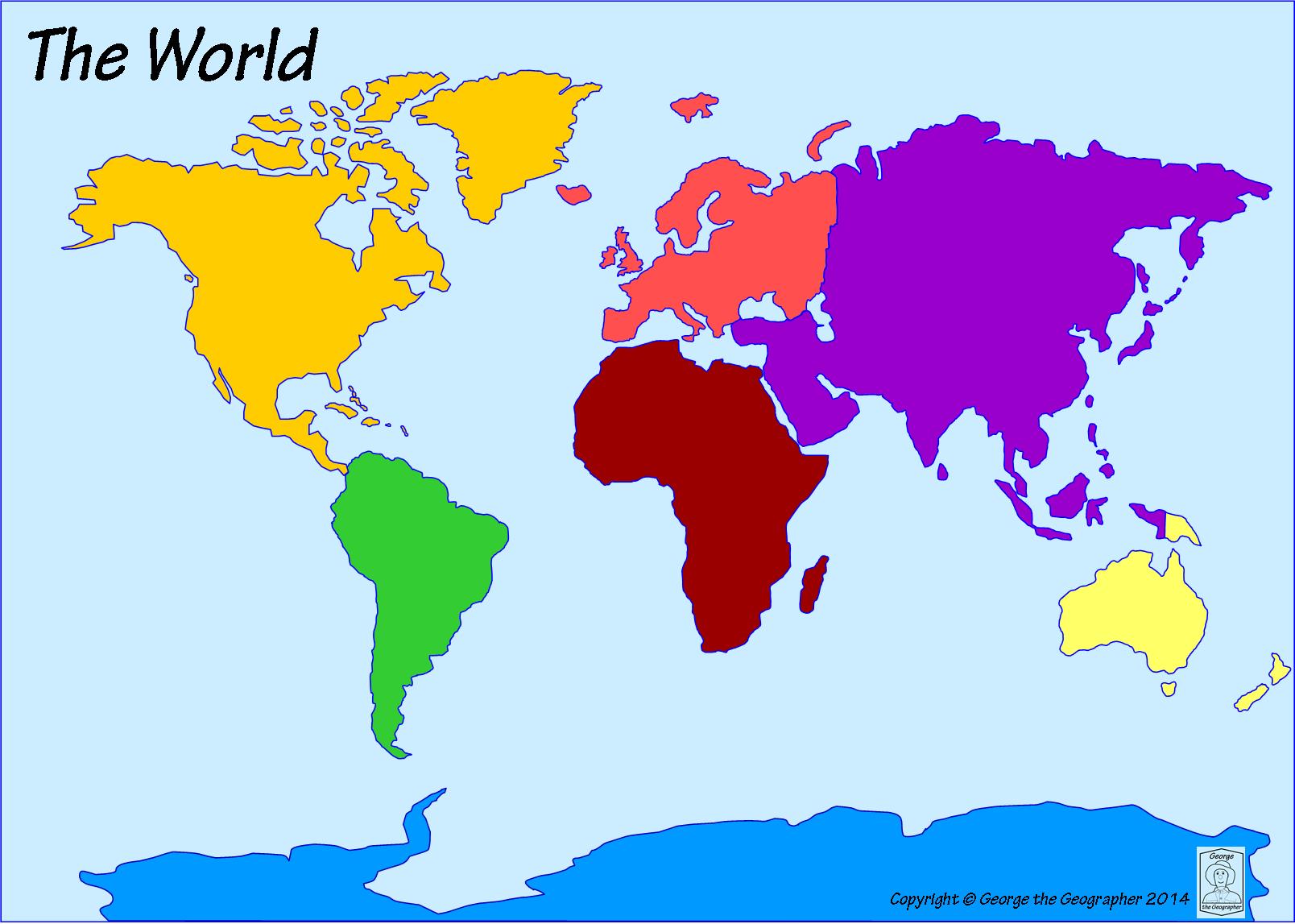
Which continent is to the east of the Indian Ocean and to the west of the Atlantic Ocean?
Africa
Europe
North America
Asia
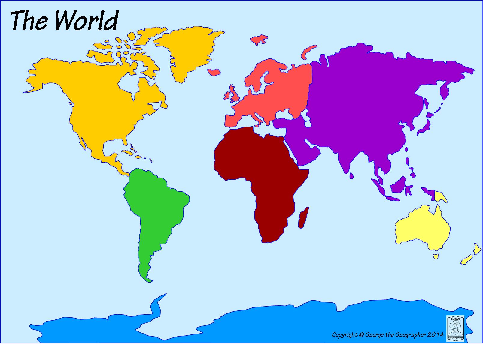
Which ocean is located to the east of Africa and to the west of Australia?
Atlantic Ocean
Indian Ocean
Pacific Ocean
Arctic Ocean
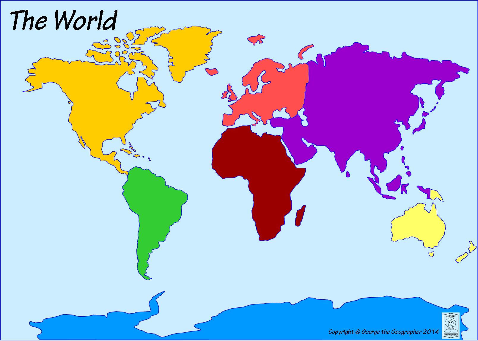
Which ocean is located off the west coast of North America. It is the LARGEST ocean.
Atlantic Ocean
Pacific Ocean
Arctic Ocean
Southern Ocean
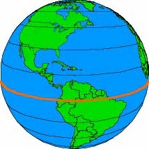
The world is divided between the Northern and Southern ___________.
Equator
Hemispheres
Continents
Oceans
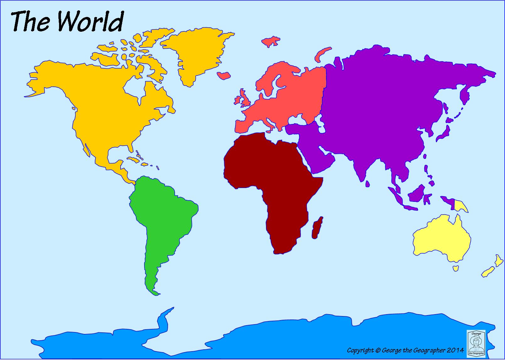
Which continent is an island continent?
Europe
North America
Antarctica
Australia
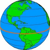
The imaginary line that divides the Earth into two parts is called the ________.
Equator
Hemisphere
Prime Meridian
North Pole
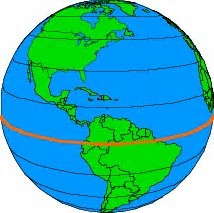
North America is located in which hemisphere?
Northern
Southern


What is the name of Utah's ancient lake?
The Great Salt Lake
Lake Bonneville
Sevier lake
Utah Lake


What’s this?
Temple of Borobudur
Taj Mahal
Sphinx of Giza
Forbidden City

What’s this?
St. Basils Catheadral
Sydney Opera House
Temple of Borobudur
Stonehenge

What’s this?
Temple of Borobudur
City of Petra
Forbidden City
Machu Pichu

What’s this?
Forbiden City
Mount of Rushmore
Temple of Borobudur
Taj Mahal

What’s this?
Coliseum
Eiffel Tower
Temple of Borobudur
Big Ben

What’s this?
Forbiden City
Mount of Rushmore
Temple of Borobudur
Colosseum

What is this?
Berlin Wall
Western Wall
Wall of Jericho
Great Wall of China
What’s this?
Temple of Borobudur
Taj Mahal
Sphinx of Giza
Forbidden City

What’s this?
Golden Bridge
Mount of Rushmore
Forbidden City
City of Petra

What’s this?
Golden Bridge
Mount of Rushmore
Tower of Pisa
Coliseum
What is this?
Berlin Wall
Western Wall
Wall of Jericho
Great Wall of China

The Collosseum was built in ancient .....
Egypt
Rome
Mexico
Greece

Taj Mahal is a gift from a King to his Queen. Where is it located?
Sri Lanka
India
Nepal
Pakistan

Humans made this famous tourist site. What is its name?
Stonewall
Stonehenge
Stonedoors
Stone tower


What is this map element called?
Legend
Star Guide
Cardinal Diamond
Compass Rose

The symbols shown are examples of items that would be found on a ______________________ of a map.
Legend
Compass Rose
Scale
Border

What does the scale on a map show?
The conversion of distance or size to the size of the map.
How many people live in a country.
The difference between kilometers and millimeters.
The way to read a ruler.

What type of map is shown?
Population Map
Climate Map
Physical Map
Political Map

What type of map is shown?
Physical Map
Political Map
Climate Map
Population Map

What is this symbol called?
Compass
Compass Rose
Map
Map Scale

What is this called?
Compass Rose
Map Key
Map Scale
Compass

What city is located closest to 70'W and 40'N?
Denver
Niagra Fallas
Boston
Houston

What is the geographical feature labeled with a letter A?
Mississippi River
Rio Grande River
Great Lakes
James River

What is the geographical feature labeled with a C?
James River
Chesapeake Bay
Rio Grande River
Mississippi River

What is the geographical feature labeled with a B?
Appalachian Mountains
Rocky Mountains
Blue Ridge Mountains
Himalayan Mountains

What is the geographical feature labeled with an E?
Appalachian Mountains
Rocky Mountains
Great Lakes
Andes Mountains
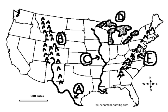
What is the geographical feature labeled with a D?
Rio Grande River
Mississippi River
Great Lakes
Chesapeake Bay


Which map part tells what the map is about?
Title
Scale
Legend
Key
Utah is named after the:
Ute Tribe
Navajo Tribe
Goshute Tribe
Shoshone Tribe
What is the highest point in Utah?
Kings Peak
Horseshoe Mountain
South Tent Mountain
Mt. Nebo

These two maps show the population density (how many people live in a place) in Utah and the average annual precipitation (yearly rainfall) in Utah. What is the relationship between population and precipitation in Utah?
The driest areas in Utah have the lowest population.
The driest areas in Utah have the highest population
The Rocky Mountains cause low precipitation in Utah.
The Great Basin is the source of precipitation in Utah.
Why did Mormon pioneers migrate to Utah?
Better Climate
More Land
Economic Opportunity
Religious Freedom


What is a state that surrounds Utah?
Idaho
California
Washington
Montana
Select 3 states that surround Utah.
Colorado
Texas
California
Wyoming
Arizona
Which are the five historic tribes of Utah?
Cherokee, Navajo, Paiute, Goshute, Chippawa
Navajo, Paiute, Goshute, Ute, and Shoshone
Ute, Paiute, Goshute, Chippawa, Navajo
Cherokee, Ute, Paiute, Shoshone, and Goshute
What is the place called where four states meet in a single place?
a dot
the bottom of Utah
a magic trick
four corners

