wayground logo

Free Printable Worksheets

NEW

Font size

S
M
L
XL
Worksheets

The Globe

Total questions: 70

Worksheet time: 54mins

Name
Class
Date
1.

Latitude and Longitude are measured in

a)

degrees

b)

inches

c)

miles

d)

kilometers

2.
Lines of Latitude can be measured up to what degree?
a)
150 degrees
b)
180 degrees
c)
90 degrees
d)
100 degrees
3.
Lines of Longitude run from the _____ to the ______.
a)
East, West
b)
North, South
c)
South, East
d)
North, West
4.
Lines of ______ measure how far from the equator a place is located?
a)
Longitude
b)
Latitude
5.
The invisible line at 0 degrees latitude is called the ________. 
a)
International Date Line
b)
Prime Meridian
c)
Equator
d)
Arctic Circle
6.
The invisible line at 0 degrees longitude is called the _________.
a)
International Date Line
b)
Prime Meridian
c)
Equator
d)
Antarctic Circle
7.

The equator divides the Earth into what two hemispheres?

a)

Eastern and Southern

b)

Northern and Southern

c)

Western and Eastern

d)

Northern and Western

8.
The Prime Meridian separates the Earth into what two hemispheres?
a)
Northern and Southern
b)
Western and Eastern
c)
Northern and Eastern
d)
Southern and Western
9.
Lines of latitude are also called  __________.
a)
hemispheres
b)
Parallels
c)
Meridians
d)
Tropics
10.
Lines of longitude are also called  ____________.
a)
Hemispheres
b)
Meridians
c)
parallels
d)
International Date Lines
11.

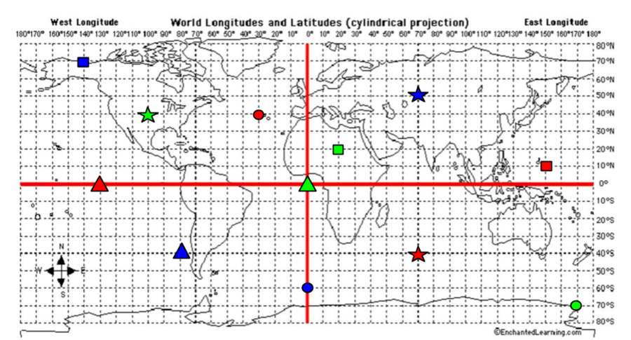
What are the coordinates for the RED star?

a)

40*S, 70*E

b)

40*N, 30*W

c)

0*, 130*W

d)

10*N, 150*E

12.

What are the coordinates for the RED Square?

a)

40*S, 70*E

b)

40*N, 30*W

c)

0*, 130*W

d)

10*N, 150*E

13.

What are the coordinates for the RED Triangle?

a)

40*S, 70*E

b)

40*N, 30*W

c)

0*, 130*W

d)

10*N, 150*E

14.

What are the coordinates for the RED Circle?

a)

40*S, 70*E

b)

40*N, 30*W

c)

0*, 130*W

d)

10*N, 150*E

15.

What are the coordinates for the BLUE Star?

a)

40*S, 80*W

b)

60*S, 0*

c)

70*N, 140*W

d)

50*N, 70*E

16.

What are the coordinates for the BLUE Circle?

a)

40*S, 80*W

b)

60*S, 0*

c)

70*N, 140*W

d)

50*N, 70*E

17.

What are the coordinates for the BLUE Triangle?

a)

40*S, 80*W

b)

60*S, 0*

c)

70*N, 140*W

d)

50*N, 70*E

18.

What are the coordinates for the BLUE Square?

a)

40*S, 80*W

b)

60*S, 0*

c)

70*N, 140*W

d)

50*N, 70*E

19.

What are the coordinates for the GREEN Star?

a)

40*N, 100*W

b)

70*S, 170*E

c)

20*N, 20*E

d)

0*, 0*

20.

What are the coordinates for the GREEN Circle?

a)

40*N, 100*W

b)

70*S, 170*E

c)

20*N, 20*E

d)

0*, 0*

21.

What are the coordinates for the GREEN Triangle?

a)

40*N, 100*W

b)

70*S, 170*E

c)

20*N, 20*E

d)

0*, 0*

22.

What are the coordinates for the GREEN Square?

a)

40*N, 100*W

b)

70*S, 170*E

c)

20*N, 20*E

d)

0*, 0*

23.
What city is located at 32 degrees south and 150 degrees east?
a)
Shanghai
b)
Sydney
c)
Durban
d)
Calcutta 
24.
Which city is located at 38 degrees north and 120 degrees west?
a)
San Fransisco 
b)
New York
c)
New Orleans
d)
London
25.
Which continent is located completely north of the Equator and west of the Prime Meridian?
a)
Asia
b)
Europe
c)
North America 
d)
South America
26.
Which continent is completely south of the Equator and east of the Prime Meridian?
a)
Antartica 
b)
South America
c)
North America 
d)
Australia 
27.
What are the coordinates for the city of New Orleans? 
a)
30 degrees north and 90 degrees west
b)
60 degrees north and 30 degrees east
c)
30 degrees north and 120 degrees east
d)
35 degrees north and 70 degrees west
28.
What are the coordinates for the city of Leningrad? 
a)
28 degrees north and 88 degrees east
b)
55 degrees north and 1 degree east
c)
28 degrees north and 88 degrees east
d)
60 degrees north and 30 degrees east
29.
If you were at 30 degrees south and 60 degrees west, which continent would you be in?
a)
Europe
b)
Africa
c)
South America
d)
Australia 
30.
If you were located at 30 degrees south and 90 degress east, what ocean would you be in?
a)
Indian Ocean
b)
Atlantic Ocean
c)
Arctic Ocean
d)
Pacific Ocean
31.
To locate the exact places on Earth, one must look at: 
a)
latitude lines only
b)
the intersecting lines of latitude and longitude
c)
longitude lines only
d)
a neighboring area to describe the location
32.
Lines of latitude and longitude are measured in:
a)
degrees of a circle
b)
north and south only
c)
east and west only
d)
degrees of a compass
33.
Latitude on a globe run from: 
a)
north to south
b)
north to west
c)
east to south
d)
east to west
34.
When measuring lines of latitude, always start with this line, which represents zero:
a)
North Pole
b)
The Prime Meridian 
c)
The Equator 
d)
South Pole
35.
When measuring lines of longitude, always start with this line, which represents zero:
a)
The Equator
b)
The Prime Meridian 
c)
The North Pole
d)
The South Pole
36.
On a globe, or map, the Equator is:
a)
The Horizontal, center line
b)
The Vertical, center line
c)
30 degree line
d)
The North Pole
37.
On a globe, or map, the Prime Meridian is:
a)
The 180 Degree Line
b)
The Horizontal Center Line
c)
The South Pole
d)
The Vertical Center Line
38.
Coordinates can be written like this:
a)
20 degrees south, 140 degrees west
b)
40 degrees north, 120 degrees west
c)
20 degrees south, 160 degrees east
d)
all of the above
39.
Which continent is located at 60 degrees north and 120 degrees west?
a)
Asia 
b)
North America
c)
Europe
d)
Africa
40.
What ocean would you be in if you were at 30 degrees south and 150 degrees west?
a)
The Atlantic Ocean
b)
The Arctic Ocean
c)
The Pacific Ocean
d)
The Indian Ocean
41.
Latitude lines go from east to west.
a)
True
b)
False
42.
Longitude lines run from north to south.
a)
True
b)
False
43.
Is this showing latitude or longitude?
a)
Latitude
b)
Longitude
44.
Is this showing latitude or longitude?
a)
Latitude
b)
Longitude
45.
The invisible line at 0 degrees latitude is called the ________. 
a)
International Date Line
b)
Prime Meridian
c)
Equator
d)
Arctic Circle
46.
The invisible line at 0 degrees longitude is called the _________.
a)
International Date Line
b)
Prime Meridian
c)
Equator
d)
Antarctic Circle
47.
The equator breaks the Earth into what two hemispheres?
a)
Eastern and Southern
b)
Northern and Southern
c)
Western and Eastern
d)
Northern and Western
48.
The Prime Meridian separates the Earth into what two hemispheres?
a)
Northern and Southern
b)
Western and Eastern
c)
Northern and Eastern
d)
Southern and Western
49.
Latitude and Longitude lines are measured in __________.
a)
inches
b)
miles
c)
degrees
d)
ounces
50.
What line of LONGITUDE is Point A located?
a)
60N
b)
105W
c)
150W
d)
48o N
51.
What line of LATITUDE is Point B located?
a)
105W
b)
60N
c)
150W
d)
80o W
52.
What line of LATITUDE is Point A located?
a)
60N
b)
105W
c)
150W
d)
48o N
53.
What line of LONGITUDE is Point B located?
a)
105W
b)
60N
c)
150W
d)
80o W
54.

The line that separates the northern and southern hemispheres is the

a)

equator

b)

prime meridian

c)

north-south line

55.

The line that separates the western and eastern hemispheres is the

a)

equator

b)

prime meridian

c)

east-west line

56.

What is the latitude and longitude of Portland?

a)

50°N, 115°W

b)

46°N, 122°W

c)

115°W, 40°N

d)

122°W, 46°N

57.

Imaginary lines on a map that run east to west (side to side).

a)

Prime Meridian

b)

Longitude

c)

Latitude

58.

Imaginary lines on a map that run north to south (up and down).

a)

Latitude

b)

Equator

c)

Longitude

59.

A line of latitude that runs around the middle of the earth at 0°

a)

Longitude

b)

Latitude

c)

Equator

60.

Which city is located at 39°N, 104°W?

a)

Phoenix

b)

Denver

c)

Fargo

d)

Portland

61.

A line of longitude that runs around the middle of the earth at 0 degrees.

a)

Latitude

b)

Absolute location

c)

Prime Meridian

62.

What is the latitude and longitude of Miami?

a)

26°N, 81°W

b)

20°N, 79°W

c)

36°N, 80°W

d)

78°W, 30°N

63.

Which city is located at 42°N, 72°W?

a)

Fargo

b)

Portland

c)

Miami

d)

Boston

64.

The Earth is divided into how many hemisphere?

a)

1

b)

2

c)

3

d)

4

65.

What is a hemisphere?

a)

Something in a car engine

b)

An imaginary line that runs East and West

c)

Half of the Earth when we divide it into two equal pieces

d)

An imaginary line that runs North and South

66.

What hemisphere appears in the picture?

a)

Northern

b)

Southern

c)

Eastern

d)

Western

67.

What hemisphere appears in the picture?

a)

Northern

b)

Southern

c)

Eastern

d)

Western

68.

What continent in the picture can be found in the Northern Hemisphere?

a)

Europe

b)

Antarctica

c)

Most of South America

d)

Australia

69.

Which continent is located in all 4 hemispheres?

a)

Africa

b)

South America

c)

Europe

d)

Antarctica

70.

How do you find the exact location of a place on Earth?

a)

Go to a gas station and ask someone

b)

Lines of Longitude

c)

Lines of Latitude

d)

The intersecting lines of latitude and longitude