
 Worksheets
Weathering, Erosion, Deposition-Advanced
Total questions: 36
Worksheet time: 20mins

What agent created this U-Shaped Valley?
Stream
Sea
Ice/Glacier
Wind

What agent created this V-Shaped Valley?
Stream
Sea
Ice/Glacier
Wind

This illustration shows a diagram of a river and the landforms it has shaped over time. This river has slowly eroded and deposited rock and sediment to form the landforms you see labeled below. Check all landforms that were formed by erosion
River Valley
Flood Plain
Delta

The picture below represents a large stream meander. The arrows show the direction of streamflow. Stream velocity was measured at surface locations A, B, and C. List the stream velocities in order from fastest to slowest in locations A, B, and C
A, B, C
B, C, A
C, B, A
C, A, B

The picture shows a meandering stream. Select two that apply for Area A.
Erosion
Deposition
Higher Velocity of Water
Slower Velocity of Water
The picture shows a meandering stream. Select two that apply for Area C
Erosion
Deposition
Higher Velocity of Water
Slower Velocity of Water

Which picture shows deposition?
B
C

The diagram shows a part of meandering stream. Lines A-A, B-B, and C-C show the locations of a stream cross section. Which cross section best represents the shape of the stream channel at line A-A?


The diagram shows a part of meandering stream. Lines A-A, B-B, and C-C show the locations of a stream cross section. Which cross section best represents the shape of the stream channel at line B-B?

The picture below depicts a stream flowing straight. At which location would the most erosion occur?
A
B
C

Two rocks of similar size and shape are shown. One is granite, while the other is sandstone. Check two that are true
Both rocks will weather
Sandstone will weather, and granite will not weather
The granite will weather, and the sandstone will not weather
The granite will weather more than the sandstone
The sandstone will weather more than the granite

The map shows part of the midwestern United States. The lines represent the borders of glaciers from the most recent ice ages. What areas will have the least amount of glacial till, based on this information?
A
B
C
D
E

The alluvial fan shown in the following illustration formed as sediment began to drop out from a stream that could no longer carry all of its sediment. Which statement best explains why the stream could no longer carry all of its sediment?
The speed of the water was too slow
The width of the stream was too small
The slope of the land was too great
The volume of water is too high
Emily used a tray filled with dirt as a model of a stream. Emily poured water into the top of the tray and observed how much erosion happened. Emily then increased the slope of the tray and repeated the experiment. What happens when the slope of the tray increased?
The speed of the water would increase, while the amount of erosion would decrease
The speed of the water would decrease, while the amount of erosion would increase
The speed of the water and the amount of erosion would decrease
The speed of the water and the amount of erosion would increase

Bryce Canyon National Park in Utah is famous for having many formations called hoodoos. Hoodoos are tall structures made of sedimentary rock. The Hoodoo Formation diagram shows the processes that create these unique rock structures. Select two main geological processes that create hoodoos.
Weathering
Erosion
Deposition

A river gradient plot shows how quickly the elevation of a river falls along its course. The slope of the line is the river’s gradient. The line has a steep slope at points along the river where the gradient is steep. The line has a nearly level slope where the river gradient is not steep.
At which location would you predict there to be the lowest streambed erosion?
A
B

A student creates a model of the mechanical weathering of rocks in a stream by shaking sugar cubes in a cup. The variable she changes is the amount of force she uses to shake the cubes. Based on her results, which picture would be a model of the weathering rocks experience in a stream with a high slope?
Light Shaking
Hard Shaking

The picture below shows the differences in size of different kinds of sediment. Which sediment will require the most force by water or wind to erode?
Gravel
Sand
Silt
Clay
A student tests which causes more weathering--plain water or vinegar (an acid) over a stream table filled with gravel. Which would you expect to cause less weathering?
Plain water
Vinegar
It doesn't matter. They will weather equal amounts.
Valleys can be made by rivers or glaciers. Mrs. Hohenstein believes her newly discovered valley is made by a glacier. What features would lead her to believe this?
Valley is shaped like a "V"
Valley is shaped like a "U"
Striations at the bottom of the glacier
Alluvial fan at the end of the valley

The rock formation below is an example of differential erosion, which occurs when the amount erosion differs, even though the rock formation experiences the same conditions. Which label shows the part of the rock that is less resistant to weathering and erosion?
A
B

The picture shows an alluvial fan. Alluvial fans form when water in a stream goes from a high slope to a nearly level slope Which graph supports the formation of a alluvial fan by comparing the velocity/speed of the water on the high slope vs the low slope?


A stream flows from a higher elevation to a lower elevation and ends in a lake. At which location would you expect the least amount of deposition?
1
2
3
4

Engineers change a stream from meandering to straight to reduce flooding. Which stream would you predict to better accommodate boat travel?
Original Stream
New, Engineered Stream
Engineers change a stream from meandering to straight to reduce flooding. Which stream travels more distance?
Original Stream
New, Engineered Stream
Engineers change a stream from meandering to straight to reduce flooding. Which stream will take less time to go down the hill?
Original Stream
New, Engineered Stream
Which ground cover is most effective at preventing mass movement?
Plants
Mulch
No ground cover

The picture below depicts a coastline. Identify features D, E, and F
D: Sea Cave
E: Sea Arch
F: Sea Stack
D: Sea Arch
E: Sea Cave
F: Sea Stack
D: Sea Stack
E: Sea Cave
F: Sea Arch
D: Sea Arch
E: Sea Stack
F: Sea cave

The graph below shows the amount of erosion and deposition on a beach from 2002-2010. In 2008 was there more erosion or deposition taking place?
Erosion
Deposition

Which two locations would have the most risk for building a house?
A
B
C
D
Which scenario will the stick figure experience the most pain from sand abrasion?


The cross section below shows the movement of wind-driven sand particles that strike a partly exposed basalt cobble located at the surface of a windy desert. Which cross section best represents the appearance of this cobble after many years of exposure to the wind-driven sand?


Check all that are effective methods of preventing mass movement and erosion
Rain
Netting
Plants
Snow
Gravel
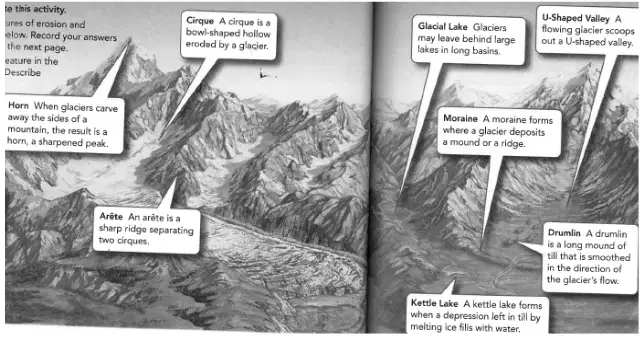
Check all landforms that are made by deposition from glaciers.
Drumlin
U-Shaped Valley
Moraine
Horn
Check all that would increase the rate of weathering
Cracks and crevices in the rock
Smooth rock
Rock deep underground
Sedimentary Rocks
Metamorphic Rocks
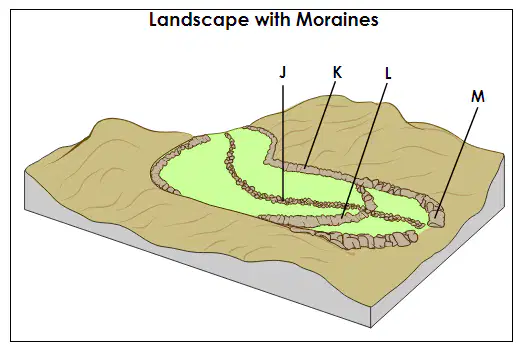
The diagram shows a landscape that includes several glacial moraines deposited during a single glacial event. The moraines are labeled.
Which moraine formed when the glacier reached its maximum advance?
J
K
L
M

