
 Worksheets
Topo Maps
Total questions: 15
Worksheet time: 17mins
Name
Class
Date
1.

Which topographic map matches formation C?
a)
1
b)
2
c)
3
d)
4
2.
If contour lines are close together, then the slope is
a)
gentle
b)
steep
c)
flat
d)
going up and down
3.
The height above sea level is called
a)
topographic
b)
contour
c)
elevation
d)
depth
4.
What are the curved lines on a topographic map called?
a)
contour lines
b)
contour intervals
c)
slope
d)
elevation
5.
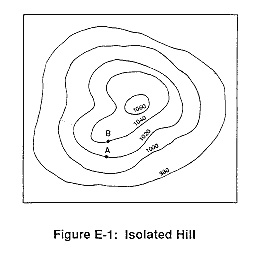
What is the contour interval on this map?
a)
100
b)
10
c)
15
d)
20
6.

How many peaks are on the map? (hill tops)
a)
4
b)
3
c)
2
d)
1
7.
It is steep on a topographic map where __________.
a)
lines are closest together
b)
a river flows into a lake
c)
contours bend
d)
contours are far apart
8.

Determine the contour interval:
a)
5 m
b)
10 m
c)
15 m
d)
20 m
9.
What do contour lines that are farther apart represent?
a)
waterfall
b)
steep area
c)
gentle slope
d)
river
10.

What is the elevation of point B?
a)
800 ft
b)
850 ft
c)
900 ft
d)
1000 ft
11.

What is the difference in elevation between Point X and Point Y?
a)
120 m
b)
240 m
c)
360 m
d)
340 m
12.

Match the topographic map to its profile.
a)
b)
c)
d)
13.

If sea level always equals (0), and the contour interval is 10 feet how tall is this mountain?
a)
30 ft
b)
40 ft
c)
50 ft
d)
60 ft
14.

The distance between contour lines is called...
a)
Contour interval
b)
Contour line
c)
Colors
d)
Mountains
15.

Provided is a topographic map of a hill with contour lines drawn showing elevation in meters.
The steepest slope on this hill can be found on the side that is facing which direction?
The steepest slope on this hill can be found on the side that is facing which direction?
a)
Southwest
b)
Northeast
c)
Northwest
d)
Southeast
100 %

