Worksheets
BJC geography - mega review
Total questions: 100
Worksheet time: 1hrs 15mins

What is the following Latin America Physical Feature?
Caribbean Sea
Pampas
Sierra Madre Mountains
Andes Mountains

What is the following Latin America Physical Feature?
Caribbean Sea
Amazon River
Atlantic Ocean
Andes Mountains

What Is The Yellow Box Surrounding?
Caribbean Sea
Amazon River
Atlantic Ocean
Pacific Ocean

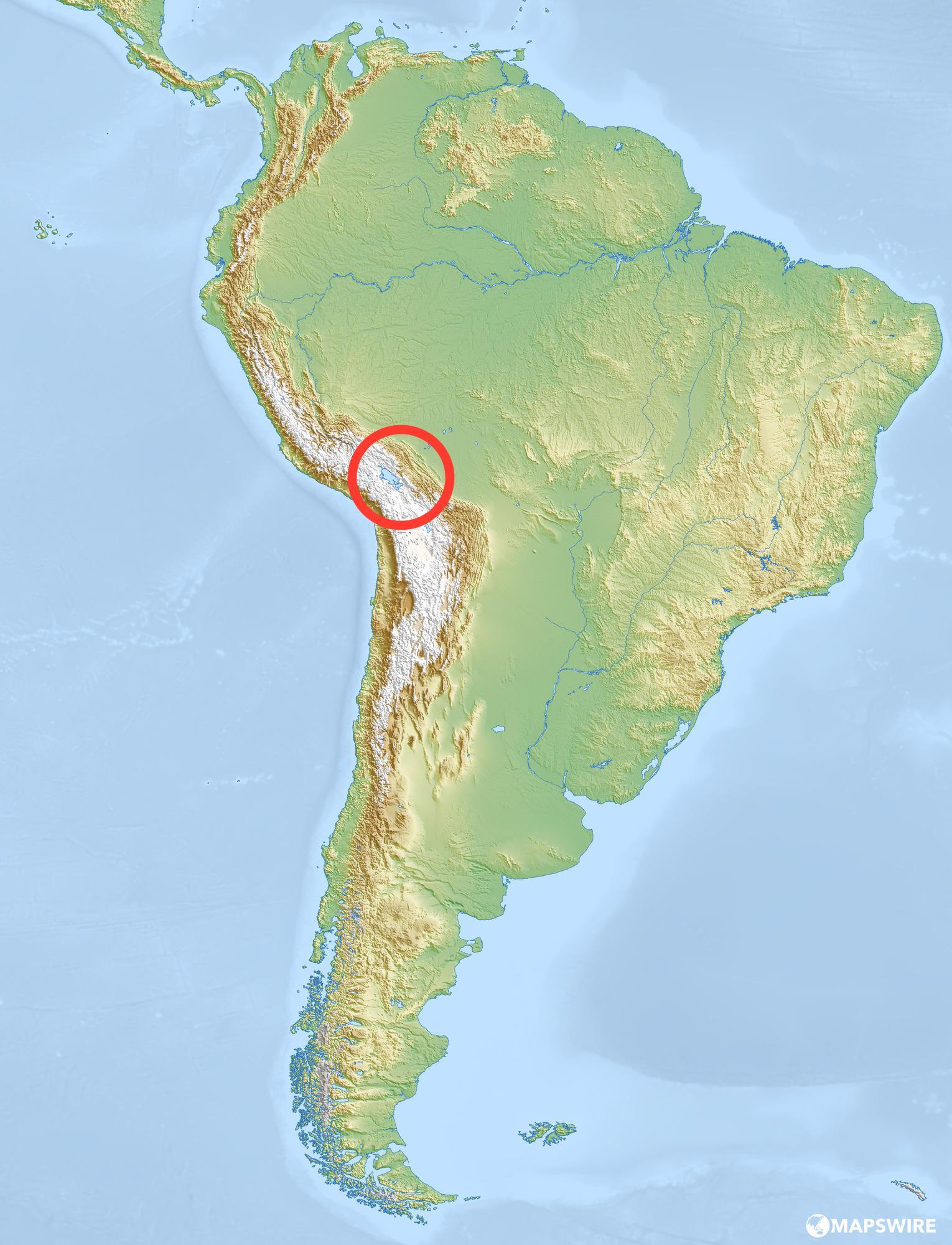
Identify This Landform In The Red Box.
Yucatan Peninsula
Pampus
Panama Canal
Andes Mountains


What landform does this show?
Strait of Gibraltar
Yucatan Peninsula
Isthmus of Panama
Cape Horn

Identify #3 on the map
France
Russia
United Kingdom
Ireland
Italy


Which physical feature is pictured?
North Sea
Volga River
Rhine River
Strait of Gibraltar


The _________________ is a body of water between Europe & Africa.
Mediterranean Sea
Aral Sea
Baltic Sea
Caspian Sea


Number 5 is
Iberian Peninsula
Scandinavian Peninsula
Strait of Gibraltar
Rhine River
Danube River

Number 4 is
Iberian Peninsula
Scandinavian Peninsula
Strait of Gibraltar
Rhine River
Danube River

What physical feature marks part of the border of the United States and Mexico?
Appalachian Mountains
Rio Grande
Mississippi River
Red River

The map above depicts the tributaries of the largest river in North America. What is the name of that river?
Rio Grande
Mississippi River
Hudson River
Brazos River

Which country is shown here
Japan
India
Spain
China

Which country is shown here?
China
Mexico
United States of America
Canada

Which country is highlighted?
Italy
France
Spain
Great Britain

Which country is highlighted?
Brazil
China
Egypt
India
Find India.


Which country is highlighted?
Russia
India
China
Japan

Which country is highlighted here?
United States of America
Mexico
Canada
Brazil
Find Japan.


Which country is highlighted?
France
Spain
Great Britain
Italy

What letter is Brazil?
J
G
B
A

What letter is the United States?
A
C
E
H

The Appalachians are located in the eastern US


The Himalayas are located in Asia & separate India from China. Mt Everest is located here.


The biggest continent in the world is
America
Europe
Asia
Africa

The smallest continent in the world is
Oceania
Europe
Asia
Africa

The ocean between Europe and America is
the Pacific Ocean
the Atlantic Ocean
the Pacific Ocean
the Indian Ocean
Earth _____ around the Sun.
Revolves
Rotates
A revolution takes one _____.
Year
Month
Day
Earth _____ around its axis.
Rotates
Revolves
Earth rotates around ____.
its axis
the Sun
A rotation takes one ____.
Year
Month
Day
When Earth faces towards the Sun, it is _____.
Day Time
Night Time
When Earth faces away from the Sun, it is _____.
Day Time
Night Time

In North America, it is ____.
Day Time
Night Time

Why do we experience the changing of the season on the earth?
distance from the sun
rotation of the earth
change in solar output
tilt of the earth's axis

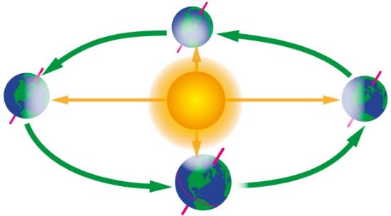
In spring, is the axis of the earth pointed away or toward the sun?
towards
Neither away or toward
away


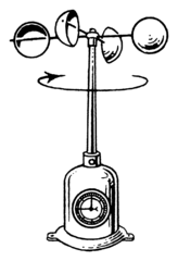
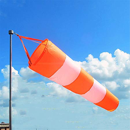
What is this instrument?
wind sock
Barometer
Anemometer
wind vane
What is the barometer used for?
To measure the wind speed
To measure the air pressure
To measure the temperature
To measure the amount of water vapor in the air
What is the thermometer used for?
To measure the wind speed
To measure the air pressure
To measure the temperature
To measure the amount of water vapor in the air
What is the hydrometer used for?
To measure the wind speed
To measure the air pressure
To measure the temperature
To measure the amount of water vapor in the air
What is climate?
the condition of the atmosphere at any given time and place
cloud cover and temperature
precipitation and humidity at a given time and place
weather conditions in an area over a long period of time
Climate is affected by many factors including:
latitude, elevation, and proximity to bodies of water
tides and currents
wind
snow and sleet
At which latitude would you expect to find the warmest air temperatures?
23.5° S
0°
66.5°N
66.5°S
These are imaginary horizontal lines parallel to the Earth's equator that run from East to West and vice versa.
Longitude
Latitude
Equator
Direction
These are imaginary lines running north-south around the globe.
Longitudes
Latitudes
Equator
Direction
Antarctica is cold all the time. What is it's climate?
Tropical
Arid/Dry
Polar
Temperate

Which river is considered holy to people of the Hindu faith?
Ganges River
Ob River
Yellow River
Yangtze River

Which African country is this?
Libya
Ethiopia
Egypt
Algeria

Which African country is this?
Madagascar
Falkland Islands
Canary Islands
Mozambique

Which African country is this?
Niger
Angola
Chad
Nigeria

Which African country is this?
Botswana
Mozambique
South Africa
Zimbabwe

Where is the Kalahari Desert?
A
B
C

Where are the Atlas Mountains?
A
B
C

Where is the Sahara Desert?
A
B
C

Where is the Red Sea?
A
B
C
D

Which body of water is located at the letter P on the map?
Niger River
Congo River
Nile River
Lake Victoria

Which body of water is located at the letter Q on the map?
Congo River
Nile River
Lake Victoria
Niger River

Which body of water is located at the letter R on the map?
Congo River
Nile River
Lake Victoria
Niger River

Name the bay labeled with the green dot on the map
Hudson Bay
Baffin Bay
Bay of Biscay
Bay of Bengal
Name the bay labeled with the blue dot on the map
Hudson Bay
Baffin Bay
Bay of Biscay
Bay of Bengal
Name the sea labeled with the brown dot on the map
South China sea
North Sea
Mediterranean sea
Caribbean sea

Name the sea labeled with the green dot
Red sea
Sea of Japan
North sea
Caribbean sea
Name the sea labeled with the orange dot
Red sea
Sea of Japan
North sea
Caribbean sea
Name the sea labeled with the red dot
Red sea
Sea of Japan
North sea
Caribbean sea
Name the sea labeled with the blue dot
Red sea
Sea of Japan
North sea
Caribbean sea

What is #1?
Hudson Bay
Baffin Bay
Bay of Bengal
Labrador Sea
What is #10?
Arabian Sea
Black Sea
Mediterranean Sea
Red Sea
What is #11?
Arabian Sea
Black Sea
Caspian Sea
Red Sea
What is #14?
Arabian Sea
Black Sea
Caspian Sea
Red Sea
What is #16?
Sea of Japan
East China Sea
South China Sea
Sea of Okhotsk
What is #19?
Coral Sea
Tasman Sea
Philippine Sea
Bering Sea
What is #20?
Gulf of Mexico
Gulf of Carpentaria
Gulf of Alaska
Persian Gulf
What is #22?
Coral Sea
Tasman Sea
Philippine Sea
Bering Sea
What is #24?
Coral Sea
Tasman Sea
Philippine Sea
Bering Sea

Identify the physical feature. (the red dot)
Cape of Good Hope
Kalahari Desert
Sahel
Congo Basin
Mount Kilimanjaro

what is this
Arabian peninsula
Sahara desert

PAMPAS
ISTHMUS OF PANAMA
BRAZILIAN HIGHLANDS
CAPE HORN