
 Worksheets
Unit 1 Review
Total questions: 66
Worksheet time: 38mins

What areas of the map are north and south the Equator?
Northwest and Northeast Quadrants
Southwest and Southeast Quadrants
Eastern and Western Hemispheres
Northern and Southern Hemispheres

The areas that are East and West of the Prime Meridian?
Northern and Southern Hemispheres
Eastern and Western Hemispheres
Northeast and Northwest Quadrants
Southeast and Southwest Quadrants
In which quadrant is Asia located?
Northeastern
Southeastern
Southwestern
Northwestern
In which quadrant is South America located?
Northeastern
Southeastern
Southwestern
Northwestern
Horizontal lines stretching east to west on a map
Latitude
Longitude
Line dividing the Earth into Eastern and Western Hemispheres
Arctic Circle
Prime Meridian
Equator
Tropic of Cancer
Line dividing the Earth into Northern and Southern Hemispheres
Arctic Circle
Prime Meridian
Equator
Tropic of Cancer

Which continent is labeled with the letter A?
Asia
Australia
South America
North America
Which continent is labeled with the letter F?
Asia
Australia
South America
North America
Which continent is labeled with the letter H?
Atlantic
Indian
Pacific
Arctic
Which continent is labeled with the letter I?
Atlantic
Indian
Pacific
Southern

In which part of South America are the Andes Mountains located?
Eastern
Western

According to the bar graph, which continent has the most land area?
Antarctica
South America
Europe
Asia
According to the bar graph, which continent has the least land area?
Australia
North America
Europe
Asia

The compass rose shows ________ on a map.
Direction
Climate
Land Mass
Population Density

The major circles of latitude located north of the Equator are called the Tropic of Capricorn and the Antarctic Circle.
True
False
The major circles of latitude located north of the Equator are called the Tropic of Cancer and the Arctic Circle.
True
False

Using latitude and longitude and/or an exact address is what theme of geography?
Proper Location
Absolute Location
Relative Location
Echolocation
Describing a particular location in terms of physical and human characteristics.
Relative Location
Region
Place
Human-Environment Interaction
A group of places that share similar physical, human, and/or cultural characteristics.
Region
Location
Place
Movement
How people, goods, ideas, information, and culture get from one location to another.
Human-Environment Interaction
Relative Location
Place
Movement
How humans adapt/modify their environment to adjust to living conditions.
Human-Environment Interaction
Relative Location
Place
Movement

Using your powers of estimation, what is the closest estimate of the distance between the two blue points?
100 kilometers
4500 kilometers
500 kilometers
20,000 kilometers

According to the pie chart, what categories of pets make up 15% of the total percentage of pets owned?
Dogs and cats
Fish, cats and rabbits
Fish, rabbits, and rodents
Rodents, cats and dogs
Jamie told her cousin about how hot and humid it was in the summer where she lived, how dry the soil would become under the intense Texas sun, and how the land was so flat that when the wind blew across the dry soil, dust covered everything all the time.
Human-Environment Interaction
Region
Movement
Place

According to the bar graph, which population had the most growth over the 30 year period measured?
Hispanics
Caucasians
Asian Americans
African Americans

What is shown here?
Latitude Lines
Longitude Lines


What is the name of this line at 0 degrees latitude?
(a)


All of the following are examples of Themes of Geography except:
Place
Location
Physical Features
Region
38 degrees South Latitude, 85 degrees East Latitude are examples of
Absolute location
Relative location
When we talk about Place within the context of the Five Themes of Geography, what do we mean?
Absolute and Relative location
The physical and human characteristics that make up an area
The interaction of people and the environment
Migration of people across the planet

Migration is one way people, ideas, and materials move.
True
False

The theme of __________ explores the relationship between people and the environment.
location
place
human-environment interaction
movement

_______________ is the study of Earth and its people.
Chemistry
Biology
Geography
Physiology

Which of the following is an example of absolute location?
the house across the street from the school
the building a mile and a half down on the right side of the road
the business at 904 North Elm Street, Oklahoma City, OK

We organize the Earth into regions to help us to learn about our world. A region is an area that has similar characteristics. Dividing large areas of the world into regions makes it easier for us to study them.
“Regions”
In the selection above, the word “region” means an area _______________________.
found only in Texas
that is off-limits to people
with no natural resources
with similar characteristics
Which theme studies how and why people, ideas, and technologies move?
movement
human-environment interaction
location
region
940 Reedy Creek Rd, Cary, NC 27513
Absolute Location
Relative Location
My house is near the park
Absolute Location
Relative Location
801 Bass Pro Ln, Cary, NC 27513
Absolute Location
Relative Location
The school is down the hill to the left
Relative Location
Absolute Location
The car is parked in the West Parking lot in spot E 42
Relative Location
Absolute Location

Which absolute location is farthest from the equator?
A
B
C
D
Which absolute location is closest to the equator?
A
B
C
D
Which absolute location would have the warmest climate?
A
B
C
D
Which absolute location would have the coldest climate?
A
B
C
D

What is the relative location of Benin?
West of Nigeria
West of Togo
South of Ghana
North o Burkina Faso
What is the relative location of Togo?
East of Nigeria
West of Benin
South of Ghana
North o Burkina Faso
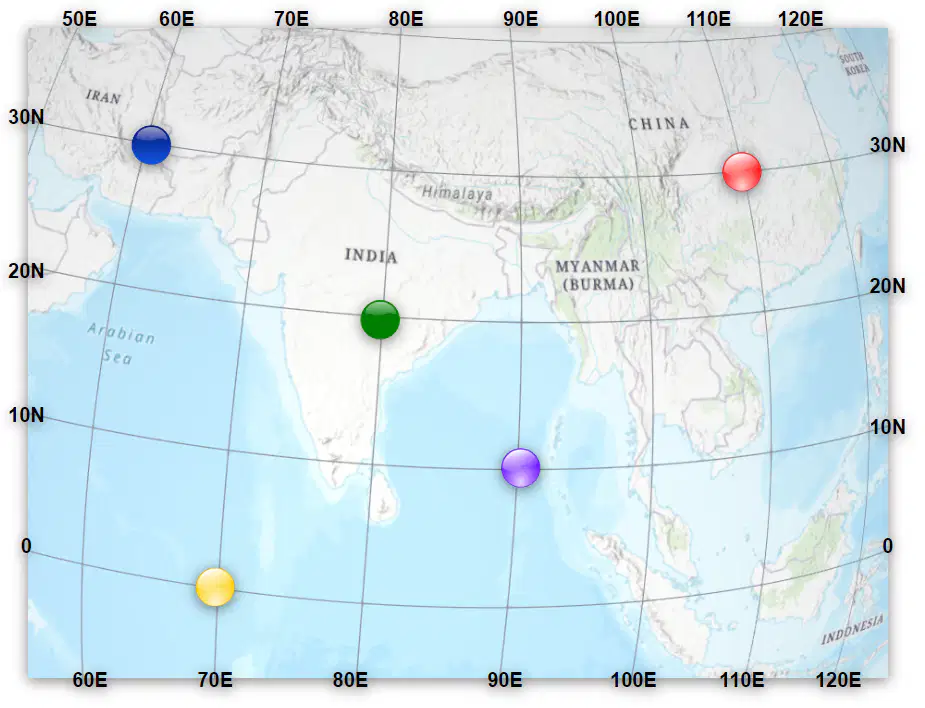
Which color dot is on the equator?
Yellow
Green
Red
Blue
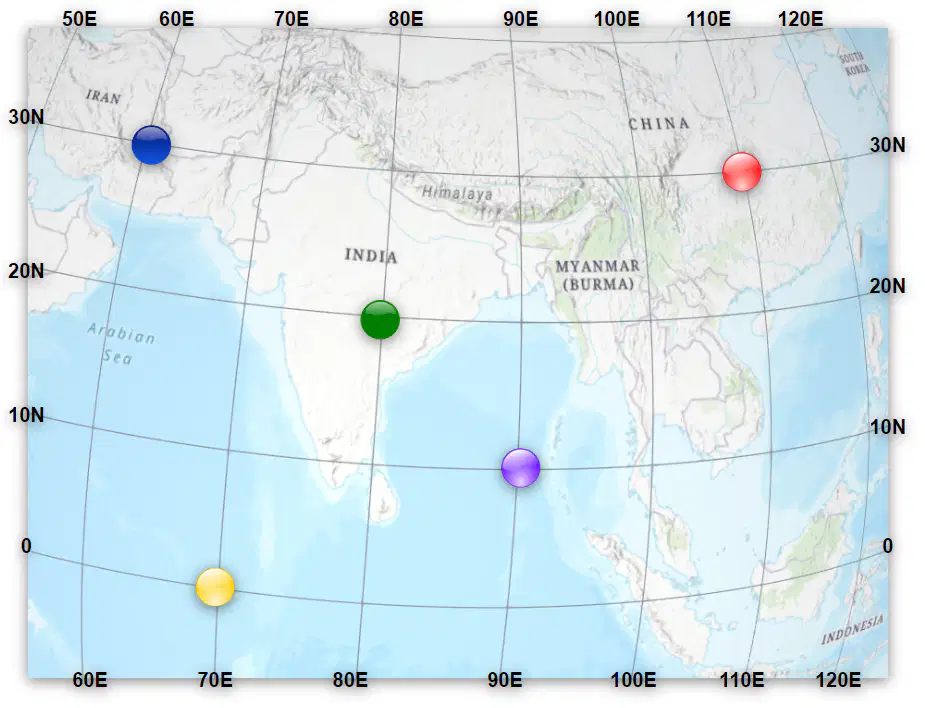
The blue and the green dots are both....
on the same latitude.
on the same longitude
on the Equator
on the Prime Meridian
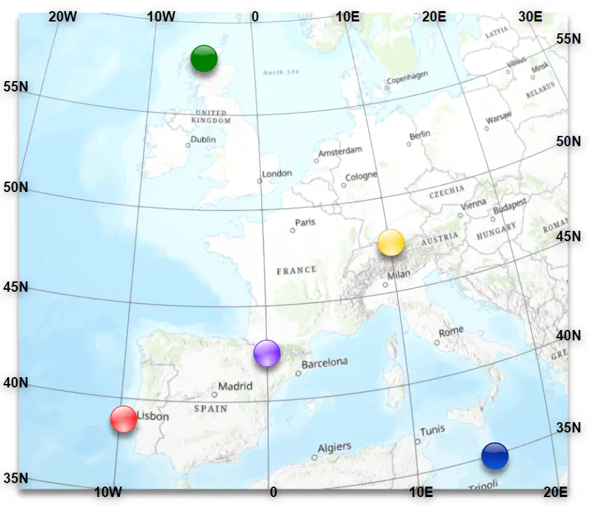
Which color dot is on the Prime Meridian?
Purple
Green
Yellow
Red
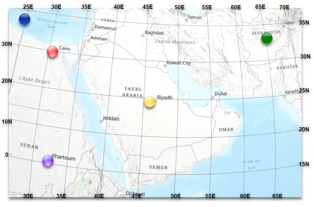
The dot that is farthest East is the...
green dot
blue dot
purple dot
yellow dot

Which quadrant are all of the dots in?
Northeast
Southeast
Northwest
Southwest
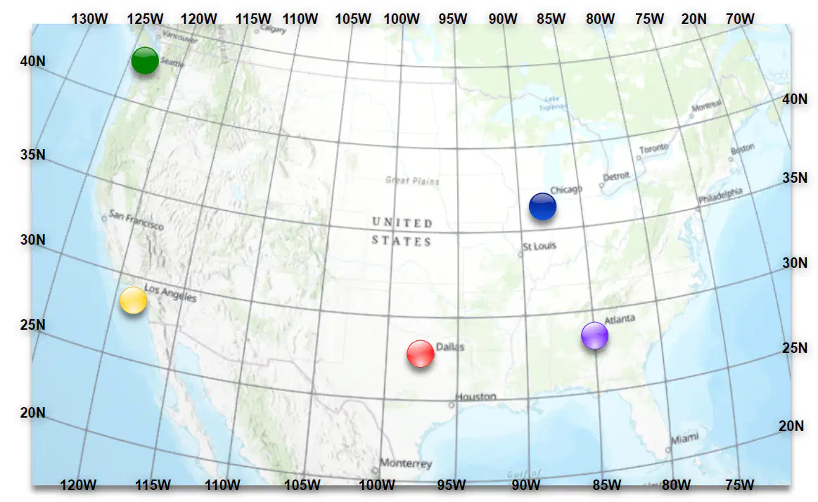
The green dot is....
farther west than the other dots.
farther south than the other dots.
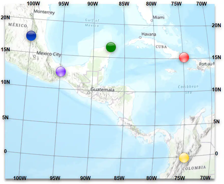
The absolute location of the red dot is....
15 North, 75 West
15 West, 75 North
75 North, 15 West
150 Northwest, 750 Eastsouth
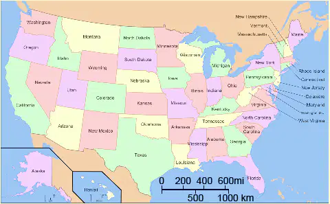
How wide is Texas?
More than 600 miles
About 400 miles
About 200 miles
Less than 200 miles

