wayground logo

Free Printable Worksheets

NEW

Font size

S
M
L
XL
Worksheets

Virginia Studies Geography 2025

Total questions: 51

Worksheet time: 31mins

Name
Class
Date
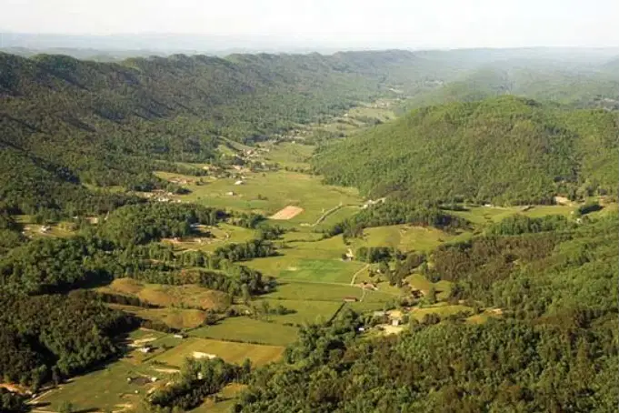
1.
Which region does the picture represent?
a)
Appalachian Plateau
b)
Piedmont
c)
Valley and Ridge
d)
Coastal Plains
2.

Jada's family is driving over rolling hills and the foot of the mountain. Which region are they in?

a)
Coastal Plains
b)
Piedmont
c)
Blue Ridge Mountains
d)
Appalachian Plateau
3.
How many regions are in VA?
a)
5
b)
6
c)
4
d)
2
4.

Which region has old rounded mountains and is the source of many rivers?
a)
Blue Ridge Mountains
b)
Piedmont
c)
Coastal Plain
d)
Appalachian Plateau
5.
Which region name is known as land at the foot of the mountains?
a)
Blue Ridge Mountains
b)
Piedmont
c)
Coastal Plain
d)
Appalachian Plateau
6.
The Great Valley of VA is located in what region?
a)
Appalachian Plateau
b)
Blue Ridge Mountains
c)
Valley & Ridge
d)
Coastal Plain
7.
A region with elevated, flat land.
a)
Appalachian Plateau
b)
Piedmont
c)
Blue Ridge Mountains
d)
Valley and Ridge
8.

All of the major rivers are separated by?

a)

the fall line

b)

the ocean

c)

peninsulas

d)

mountains

9.
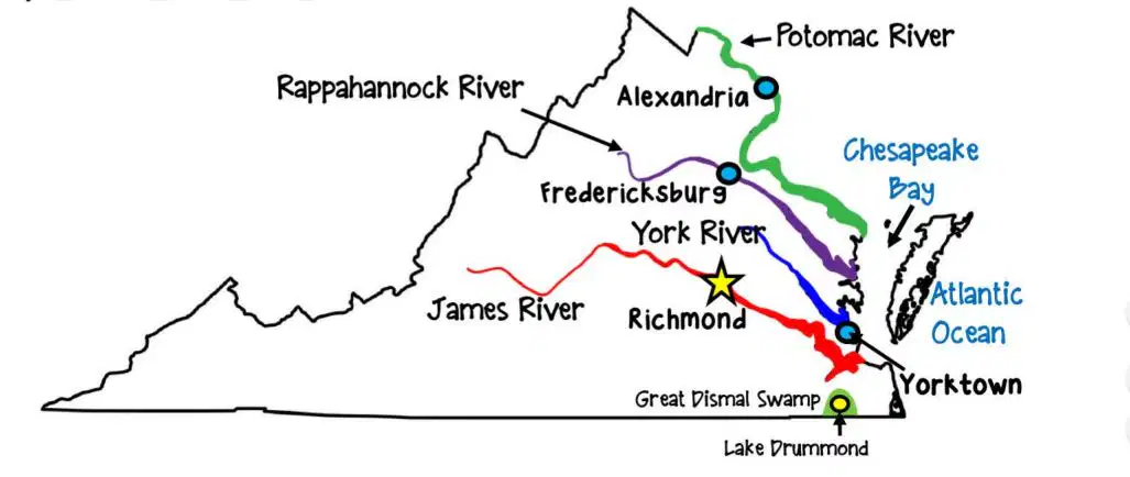
Fredericksburg is located on the---
a)
Rappahannock River
b)
Potomac River
c)
James River
d)
York River
10.
Which two cities are located on the James River?
a)
Jamestown & Alexandria
b)
Richmond & Yorktown
c)
Yorktown & Richmond
d)
Jamestown & Richmond
11.
The York River has which city located on it?
a)
Yorktown
b)
Williamsburg
c)
Richmond
d)
Alexandria
12.
Select the two large bodies of water that border VA to the east.
a)
Pacific Ocean & Atlantic Ocean
b)
York River & Chesapeake Bay
c)
Chesapeake Bay & Atlantic Ocean
d)
Chesapeake Bay & Pacific Ocean
13.
--- is a shallow, natural lake surrounded by the Dismal Swamp, located in the Coastal Plain.
a)
Lake Draining
b)
Lake Drummond
c)
Lake Washington
14.
Name the peninsula which is bordered by the Atlantic Ocean & Chesapeake Bay.
a)
Western Shore
b)
Piedmont
c)
Tidewater
d)
Eastern Shore
15.
Which list includes the 5 surrounding states of VA?
a)
Maryland, West VA, South Carolina, Georgia, Tennessee
b)
Maryland, Tennessee, North Carolina, West VA, Kentucky
c)
Kentucky, Tennessee, Ohio, Maryland, North Carolina
d)
Tennessee, South Carolina, Maryland, West VA, Georgia
16.
Define the word "peninsula".
a)
A large body of water bordering land.
b)
A piece of land bordered on all sides by water.
c)
A piece of land bordered on 2 sides by water.
d)
A piece of land bordered on 3 sides by water.
17.
The Fall Line is the natural border between which two regions?
a)
Appalachian Plateau & Valley & Ridge
b)
Blue Ridge & Coastal Plain
c)
Coastal Plain & Piedmont
d)
Blue Ridge & Piedmont
18.
What water feature in Virginia has a variety of wildlife and was explored by George Washington?
a)
Smith Mountain Lake
b)
New River
c)
Dismal Swamp
d)
Clinch River
19.

Which regions are part of the Appalachian Mountain system?

a)

Coastal Plain and Piedmont

b)

Piedmont and Appalachian Plateau

c)

Valley and Ridge and Blue Ridge Mountains

d)

Valley and Ridge and Coastal Plain

20.
What body of water provided transportation links between Virginia and Europe?
a)
James River
b)
Atlantic Ocean
c)
Chesapeake Bay
d)
Potomac River
21.
Which region is a source of many Virginia rivers?
a)
Coastal Plain
b)
Piedmont
c)
Blue Ridge
d)
Valley and Ridge
22.
Which region is labeled with a "2"? 
a)
Appalachian Plateau
b)
Valley and Ridge
c)
Coastal Plain
d)
Blue Ridge Mountains
23.
Which region is represented in  this picture?
a)
Valley and Ridge
b)
Piedmont
c)
Blue Ridge Mountains
d)
Coastal Plain
24.
Which region includes the Eastern Shore?
a)
Coastal Plain
b)
Piedmont
c)
Blue Ridge Mountains
d)
Valley and Ridge
25.

Which region is directly east of the Fall Line?

a)

Valley and Ridge

b)

Piedmont

c)

Coastal Plain

d)

Appalachian Plateau

26.
This region is located in the southwest part of Virginia.
a)
Appalachian Plateau
b)
Valley and Ridge
c)
Blue Ridge Mountains
d)
Piedmont
27.
Which body of water provided a safe harbor and was a source of food and transportation?
a)
Atlantic Ocean
b)
Chesapeake Bay
c)
James River
d)
Potomac River
28.
Which rivers flow into the Chesapeake bay?
a)
James & Potomac
b)
Potomac & Rappahanock
c)
York, James, Richmond
d)
Potomac, Rappahanock, York and James
29.
The ______ and the _____ are the two largest water features that border Virginia.
a)
Chesapeake Bay and Pacific Ocean
b)
Chesapeake Bay and Atlantic Ocean
c)
James River and Atlantic Ocean
d)
James River and Pacific Ocean
30.
The city of Yorktown is located along the ___ River.
a)
York
b)
Rappahannock
c)
James
d)
Potomac
31.
The city of Alexandria is located along the ___ River.
a)
York
b)
Potomac
c)
James
d)
Rappahannock
32.
The cities of Jamestown and Richmond are located along the ____ River.
a)
York
b)
James
c)
Rappahannock
d)
Potomac
33.
Which number represents the Chesapeake Bay? 
a)
1
b)
3
c)
4
d)
2
34.

Which region is identified by the number 5?

a)

Coastal Plain (Tidewater)

b)

Valley and Ridge

c)

Piedmont

d)

Blue Ridge Mountains

35.

A ship is sailing from the Chesapeake Bay to Alexandria, what river are they sailing on

a)

Potomac

b)

James

c)

York

d)

Dismal Swamp

36.
Which region is identified as number 1?
a)
Coastal Plain (Tidewater)
b)
Valley and Ridge
c)
Blue Ridge Mountains
d)
Piedmont
37.

What region of Virginia is represented by PURPLE on the map?

a)

Blue Ridge Mountains

b)

Coastal Plain

38.
Which region is shaded in green?
a)
Coastal Plain
b)
Piedmont
c)
Appalachian Plateau
d)
Valley and Ridge
39.

The places on the map above are located along the -

a)

James River

b)

York River

c)

Rappahannock River

d)

Potomac River

40.

The Potomac, Rappahannock, James and York rivers flow into the —

a)

Chesapeake Bay

b)

Roanoke River

c)

The Atlantic Ocean

41.

What body of water is located east of the Eastern Shore?

a)

Lake Drummond

b)

Chesapeake Bay

c)

Dismal Swamp

d)

Atlantic Ocean

42.

Which river is located at Point A?

a)

James River

b)

Ohio River

c)

Potomac River

d)

York River

43.

Which river is located at Point D?

a)

James River

b)

Ohio River

c)

Potomac River

d)

York River

44.

Which river is located at Point C?

a)

James River

b)

Rappahannockl River

c)

Potomac River

d)

York River

45.

Which river is located at Point B?

a)

James River

b)

York River

c)

Potomac River

d)

Rappahannock River

46.

Which of the following statements describes the Chesapeake Bay?

a)

It  provided a pathway for exploration and settlement of Virginia.

b)

It was a source of food and a safe harbor for ships.

c)

It was a transportation link to other countries.

d)

It is a shallow natural lake surrounded by the Dismal Swamp.

47.

Name the body of water in the Coastal Plain region that is marked on the map, with a star.

a)

Chesapeake Bay

b)

Lake Drummond

c)

York River

d)

Fall Line

48.

Which body of water provides safety for ships (blocked

from the Atlantic Ocean)?

a)

Chesapeake Bay

b)

Atlantic Ocean

49.

Which letter represents the approximate location of Virginia

a)

A

b)

B

c)

C

d)

D

50.

All the major rivers serve as an important source of

a)

peninsulas

b)

animals

c)

food

d)

vacation spots

51.

How did the rivers helps early settlers?

a)

the could vacation together

b)

they went white water rafting

c)

the rivers did not help people

d)

its was a source of water and help them to trade