
NEW
Font size
 Worksheets
Weather Test
Total questions: 46
Worksheet time: 3hrs 23mins

This weather instrument is a _______________ - it orbits Earth's atmosphere gathering data.
rain gauge
U.F.O.
satellite
anemometer
This instrument measures wind speed.
anemometer
barometer
rain gauge
thermometer

The lines on a weather map connect equal areas of pressure are called
contour lines
isotherms
isobars
longitude
The lines on a weather map connect equal areas of temperature are called
contour lines
isotherms
isobars
longitude


What is METEOROLOGY?
the study of rain and Earth’s atmosphere
the study of weather and Earth’s atmosphere
the study of climate and Earth’s atmosphere
the study of maps and Earth’s atmosphere
What is weather forecasting?
the analysis of scientific data to predict future weather conditions
the analysis of scientific data to see the weather conditions
the news on TV
the analysis of maps to tell the weather conditions
Name of the scientist who studies meteorology is ...
climatologists
weather man
meteorologists
mechanic
Radar is useful for ...
finding the intensity of storms, including tornadoes
finding the location, movement, and intensity of storms, including tornadoes
finding the weather
finding important things about the weather
Balloons are useful for ...
predicting the weather
gathering weather information during different times of the day
gathering weather information at different altitudes
finding the location, movement, and intensity of storms, including tornadoes
Satellites are useful for ...
gathering weather information at different altitudes
finding the location, movement, and intensity of storms, including tornadoes
gathering data on water vapor, cloud-top temperatures, and the movement of weather systems
collecting data on air pressure, temperature, humidity, precipitation, wind speed, visibility, and cloud cover
Jet streams are long, wide air currents in the upper atmosphere. They often affect weather over large areas. In what direction do jet streams above North America usually flow?
north to south
east to west
west to east
south to north

_____ is caused by the difference between high and low pressure areas.
Wind
Air Pressure
Humidity
Temperature
_____ is the force of air molecules pushing on an area.
Wind
Air Pressure
Humidity
Temperature
_____ is the amount of water vapor in the air.
Wind
Air Pressure
Humidity
Temperature

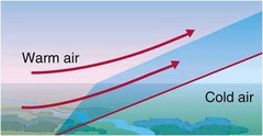


Which is the correct symbol for an occluded front?


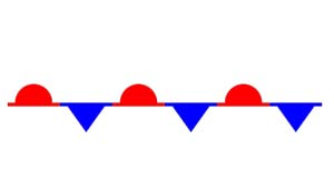

Which is the correct symbol for a stationary front?


What are isobars?
Lines connecting places of equal temperature
Lines drawn connecting places of equal pressure
Lines drawn to places of different temperatures
Lines drawn to places of different pressures
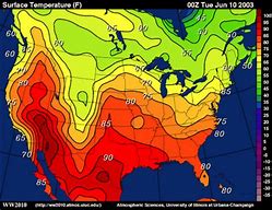
These maps connect points of equal temperature (THERMometer).
Isobar map
Isodown map
Isotherm map
Temperature map
What is a station model
A record of weather data for a particular site at a particular time
A model of a station
recent data
weather for the rest of the week
Analog Forecast
All of the above
Based on a comparison of current weather patterns with similar weather patterns from the past
Present weather
Future weather
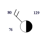
What is the temperature for the following station model?
4 ºF
76 ºF
80 ºF
129 ºF
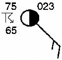
What is the dewpoint for the following station model?
10 ºF
23 ºF
65 ºF
75 ºF
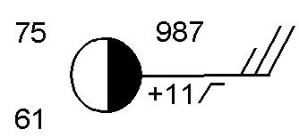
What is the barometric pressure for the following station model?
987 mb
998.7 mb
1098.7 mb
1098 mb
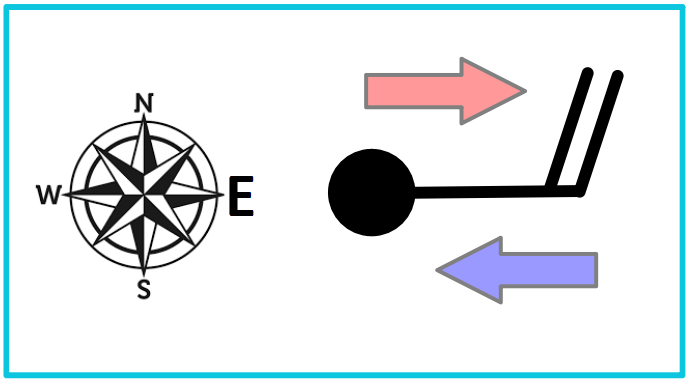
Based on the picture, what direction is the wind blowing?
To the east
From the east
To the South
To the North
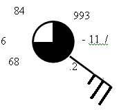
What is the amount of cloud cover for the following station model?
25%
50%
75%
100%



