
 Worksheets
Unit 7 Africa Review - WG
Total questions: 107
Worksheet time: 1hrs 7mins

According to the maps, most people in Africa live —(WG.6A)
near the coast where the climate is more temperate
in the interior where the climate is milder year-round
near the coast where there is better access to transportation routes
in the interior where there are better employment opportunities (WG.6A)

The projected growth in African cities between 2010 and 2025 is attributed to —
trade
urbanization
famine
colonization

Which factor best explains the growth in urban populations?(WG.7C)
Less pollution
Climate change
Economic opportunities
Higher birth rates

What would BEST account for the lack of population in the southwestern portion of Africa?
The Sahara Desert
The Kalahari Desert
dense tropical rainforests
repeated volcanic activity

Which is the BEST explanation for the geographic location of the these ancient Egyptian cities and towns?
They were all located along the Nile for military defense purposes.
They were all located along the Nile for better trade with the Romans.
They were all located along the Nile because of irrigation, trade, and transportation.
They were all located along the Nile to limit contact with and to stay away from other nations.

What is the BEST explanation for the population density in the red circled area?
The region is home to trade, industry, and adequate precipitation.
The region is dominated by a desert climate.
The region has suffered civil wars and invasions.
The region was once the central focus of the trans-Atlantic slave trade.

The area indicated with the red arrow has a very low population density because it
floods annually.
is dominated by desert.
has been plagued by invasion.
is prone to outbreaks of disease.
Which factor is MOST LIKLEY to have had the greatest impact on human settlement patterns in Sub-Saharan Africa?
proximity to the region's numerous coal mines
proximity to water sources needed for subsistence farming
political boundaries created during European colonization
urbanization resulting from the growth of the oil industry in the region
Why are the majority of Sub-Saharan African cities located along major rivers and the coast?
they grew up because of internal tribal wars
they needed access to bodies of water for trade
the interior is filled with desert and mountains
the exterior is filled with desert and mountains
Which African region has been negatively affected by commercial logging, excessive fuel wood consumption, and slash and burn farming techniques?
the Sahel
the Sahara
the savanna
the rainforest

Until the mid-20th century the largest impediment to trade between area "1" and area "2" on the map was
geography.
religion.
lack of knowledge.
lack of tradable goods.

People in the Democratic Republic of Congo (shown in green) would be MOST affected by which of these?
tsunamis
earthquakes
desert conditions
rainforest conditions


Climate, landforms, and vegetation are types of ________ features.
physical
human
absolute
technological

Population, economic activity, and land use are types of _______ features.
technological
physical
human
absolute

What type of feature is this?
Human Feature
Physical Feature

What type of feature is this?
Human Feature
Physical Feature
When people decide where to settle or live in a certain area, what physical characteristic would they be more attracted to?
Near a desert
On a mountain
Near a river or ocean
Where is snows every day of the year

What does the key on this map tell us about population?
Population is expected to decline by 2050 in Africa
Population is expected to grow by 2050 in Africa
Population stay the same by 2050 in Africa
Population will migrate from Africa to North America by 2050
These regions have the mildest temperatures due to not being the furthest away from direct sunlight and due to not receiving direct sunlight. This is where majority of the world's population lives.
Temperate
Prime Meridian
International Date line
Location


Which of the following is an example of a common geographic physical feature in East Africa?
Rift valleys
Mountains/Highlands
Coast
all of the above

Located in central Africa and flows west through the Tropical Rainforest, this river is known as the second longest river in Africa. What is the name of this river?
Congo River
Niger River
Nile River
Amazon River

What is the geographical region called that is made up of dry, hot grasslands, and it covers half of Africa?
The Savanna
The Tropical Rainforest
The Sahel
The Sahara Desert

Which geological landmark is a trenched area that has extreme tectonic plate movement and experiences many earthquakes?
The Congo River
Mt. Kilimanjaro
The Sahel
The Great Rift Valley

Located in the southwestern part of Africa, this geographical region is not considered a "true desert" because it receives 3-10 inches of rainfall per year. Which geographical region is being described?
The Sahara Desert
The Kalahari Desert
The Savanna
The Sahel

Located in northern Africa, this geographical region is the world's largest desert. Which geographical region is being described?
The Gobi Desert
The Kalahari Desert
The Sahara Desert
The Great Victoria Desert

Located south of the Sahara Desert, this geographical region consists of grasslands and has a dry, semi-arid climate. The region is slowly turning into desert. Which geographical region is described?
The Sahara Desert
The Tropical Rainforest
The Sahel
The Savanna

Which geographical landmark located in northern Africa separates the coastal region of Africa from the Sahara Desert?
Atlas Mountains
Ural Mountains
Mt. Kilimanjaro
Mt. Everest

Located in eastern Africa, this geographical landmark is considered the world's longest river. Which geographical landmark is being described?
The Congo River
The Niger River
The Mississippi River
The Nile River

Located in the central part of east Africa, this geographical landmark is the largest lake in Africa. Which geographical landmark is being described?
Lake Victoria
Lake Helen
Lake Michigan
Lake Kilimanjaro
What is an example of a physical trade barrier in Africa?
Quota on Egyptian cotton sheets
Tariff on Nigerian oil
The Sahara desert
Embargo on South Africa

Desertification would MOST impact which climate area first?
Sahel
Mediterranean
Tropical Savanna
Tropical Rainforest
Many people in Africa lack access to clean water.
True
False
"Unequal access to water" means all regions of Africa struggle with water scarcity.
True
False
Which physical feature usually has the highest population density?


The circled blue area on this map is
a lake
a desert
a mountain
Population density is higher near water sources.
TRUE
FALSE

Why do people build dams?
to provide water for irrigation
to generate electricity
for economic benefits
ALL OF THE CHOICES

Which river is represented by the number 3?
Niger River
Congo River
Nile River
Tigris River
What are the largest areas of land on Earth called?
mountain
plain
continent
country
What are pictures on a map called?
symbols
photos
pixels
signs

What does a map scale do?
shows how big the map is
shows how much a map weighs
shows how tall a building is in real life
shows how far away a place is in real life

Which type of map shows the borders between countries?
physical
political
population
elevation

Which type of map shows the height of the land?
physical
political
population
elevation

Which type of map shows where mountains and plains are located?
physical
political
population
elevation

North, South, East, and West are which kind of directions?
Intermediate
Normal
Cardinal
Basic

What is another name for a map key?
graph
ruler
legend
scale
Which part of a map helps orient direction?
legend
compass rose
title
scale

What map freely distorts shapes, directions, and areas to display statistics?
Thematic maps
Road maps
Cartograms
Physical maps

Which type of maps would be best suited for displaying a particular set of information such as temperature, GDP, or ethnicity in a particular geographic area?
Reference maps
Thematic maps
A Cartogram is
a map made by an astronomer
a mapmaker
a map that adjusts the size of a country to show an amount of a topic (e.g., total number of people)
a map that shows population density (e.g. total number of people per square mile)
Which of the following is an example of a cartogram?


What is the first thing you should do when you are trying to “read” or “analyze” this type of map?
look at the United States compared to China
figure out what each square means on the map
try and figure out why the map is so distorted
try and figure out where Chicago is on the map
What does each square represent on the map above?
Population
Oil Consumed
Calories
Gross Domestic Product (GDP)

What continent is #1?
Europe
Australia
North America
South America

What is continent #2?
North America
South America
Africa
Antarctica

What is continent #3?
Africa
Asia
Australia
Antarctica

What is continent #4?
Europe
Asia
Africa
Australia

What is continent #5?
Europe
Asia
Africa
North America

What is continent #6?
North America
Asia
Europe
Antarctica

What is continent #7?
South America
Africa
Europe
Australia

What ocean is #3?
Pacific Ocean
Atlantic Ocean
Indian Ocean
Arctic Ocean

What ocean is at Letter "C"?
Pacific Ocean
Atlantic Ocean
Indian Ocean
Arctic Ocean

According to the map what area of Africa do more people live in?
Away from the Sahara and Kalahari deserts
Near large bodies of water
near the coasts
All of the these

This map represents which of the following?
Hint: Population is shown by country so we are able to understand how many people (per square kilometer) live around the world.
Population Distribution
Population Density

This map shows countries in Africa that practice Islam. How could the physical geography of Africa explain why Islam did not spread into Southern Africa?
The climate of Central Africa is not conductive to Islam
Mountains in Central Africa blocked the diffusion of Islam to the south
The Sahara desert formed a physical barrier that blocked diffusion of islam from the North to South
Travel down the Nile River is risky so Muslims did not use it to travel South

Based on this map, which African country receives the most rain?
South Africa
Egypt
Somalia
Central African Republic

Where is the Kalahari Desert?
A
B
C

Where are the Atlas Mountains?
A
B
C

Where is the Sahara Desert?
A
B
C

Where is the Nile River?
A
B
C
D

Where is the Red Sea?
A
B
C
D

Where is Lake Victoria?
A
B
C
D

What physical feature is located in Northern Africa?
Sahara Desert
Rocky Mountains
Rio Grande
Amazon Rainforest
Which physical factor is most responsible for the settlement pattern in Egypt where the population is concentrated onto three percent of the land area?
Mediterranean Sea
Sahara Desert
Red Sea
Himalayas
European countries cut up almost the entire ________________________ into a collection of colonies. This has led to the diversa cultural landscape of modern day.
world
country of India
continent of Africa
continent of South America
Which factor most accounts for the creation of the political borders in Africa?
Colonial territory claims
Physical boundaries
Climate conditions
Ethnic divisions
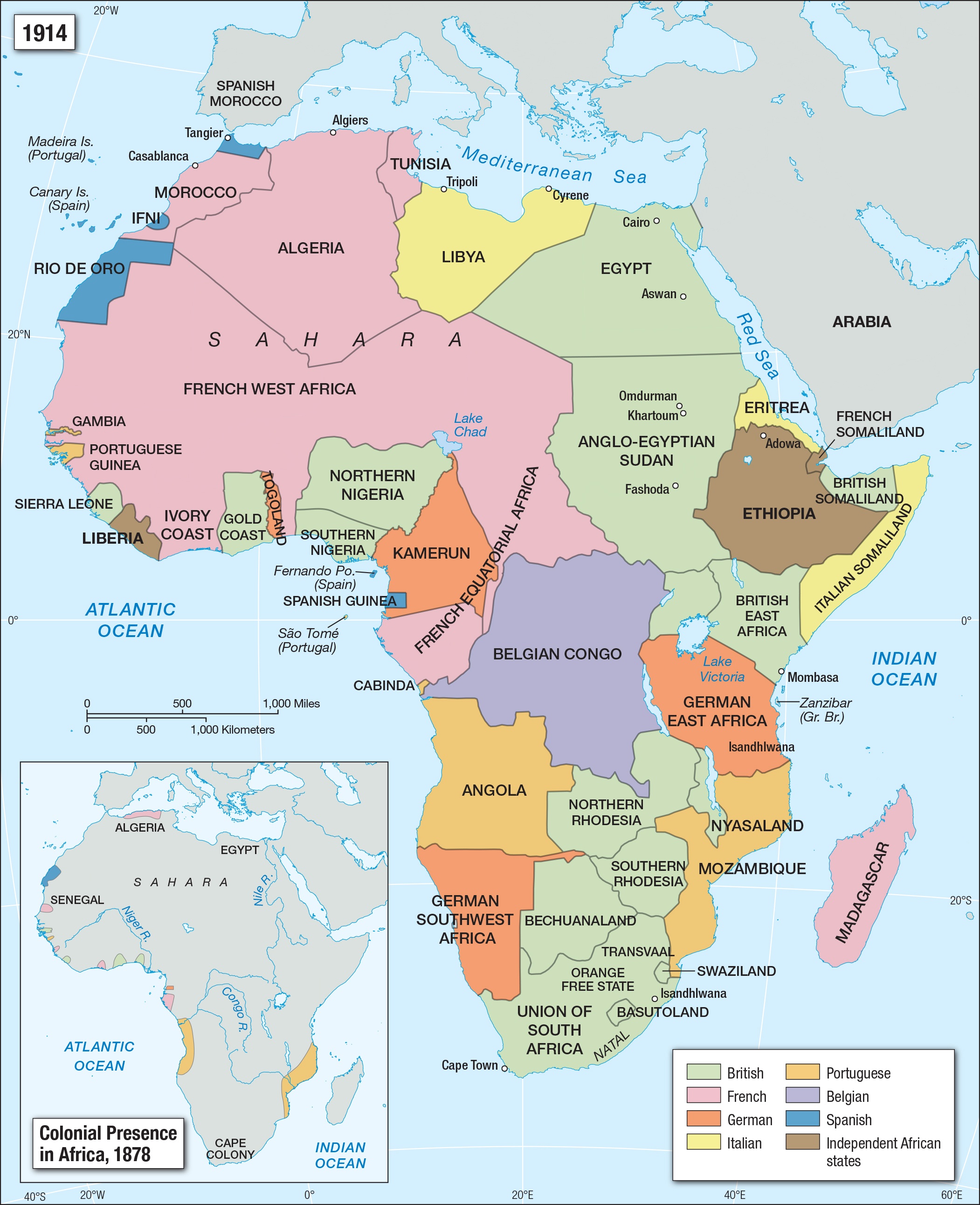
When a country controls the lands of another to gain from their resources and sends settlers...
colonialism
segregation
enclave
partition

How did the Europeans “partition” Africa?
At the Berlin Conference in 1884 the European countries divided Africa for natural resources.
At the Paris Conference in 1886 the European countries divided Africa for natural resources.
European countries just showed up with their military and took over.
Europe never took anything from Africa.
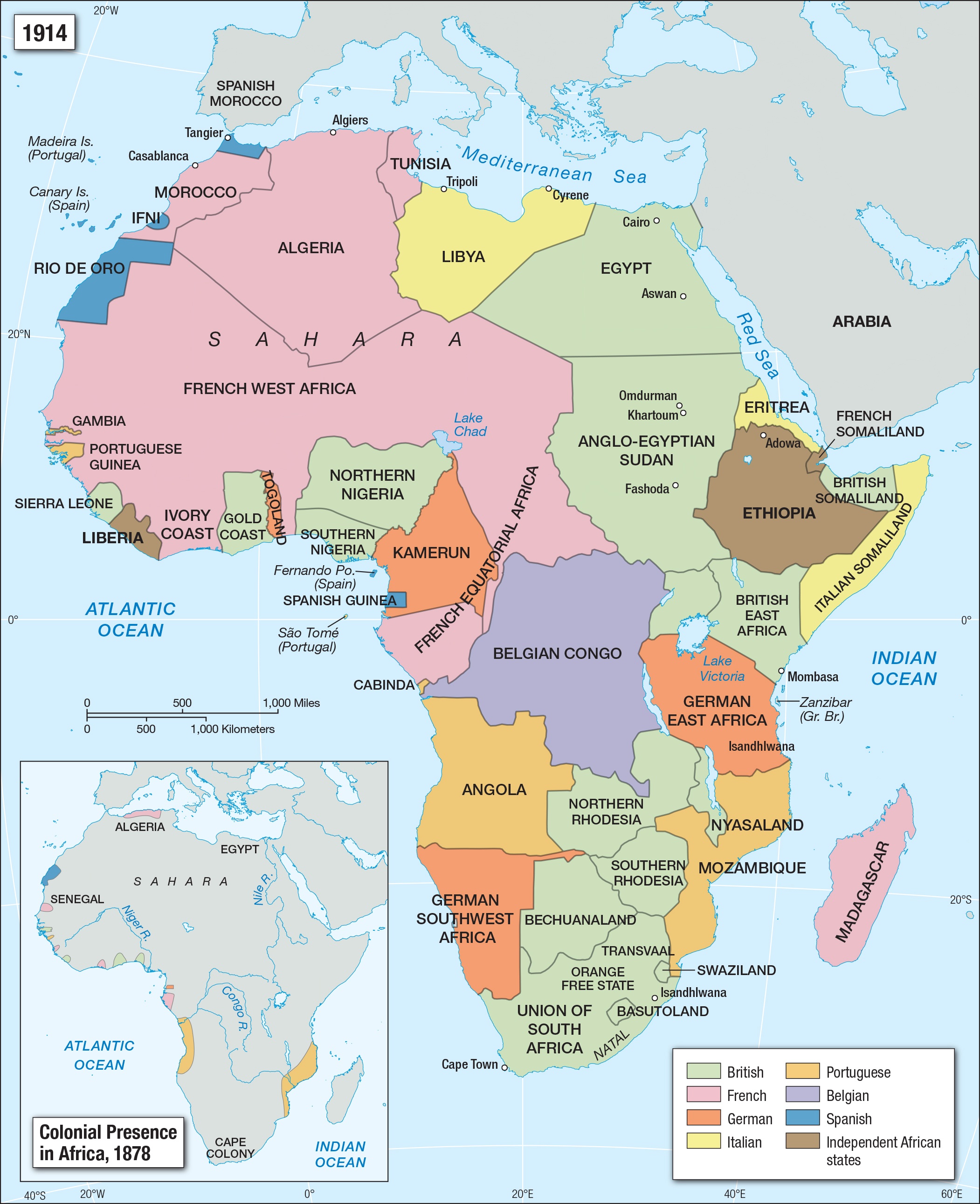
The modern day political boundaries, civil wars, and conflicts found in Africa can often be traced back to which of the following event?
European partitioning and colonization
Ancient African trading empires
European cooperation in the late 1800s
Asian invasions in the 1800s
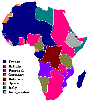
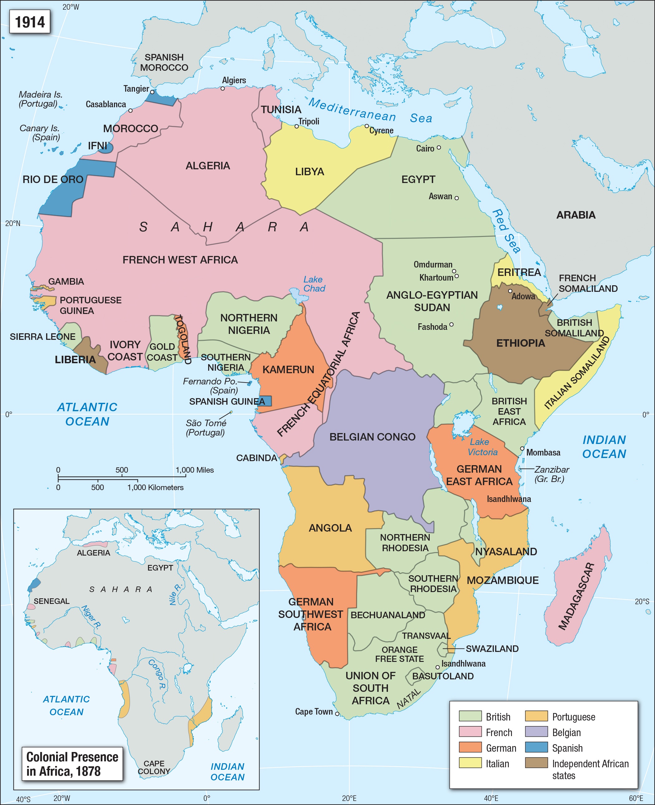
Which conclusion is accurate based on the map above?
the partitioning of Africa into colonies creates uneven and artificial political boundaries
European countries divided Africa because there were no civilizations there in 1914
modern African countries probably enjoy these boundaries because they all follow rivers
there were so many European countries that had colonies in Africa, so there was little conflict
The invasion, occupation, colonization, and annexation of Africa territory by European powers during the New Imperialism period between 1881 & 1914
Apartheid
Colonization
Scramble for Africa
Imperialism

What does partitioning mean?
to divide up
to take over
to cause conflict
to teach
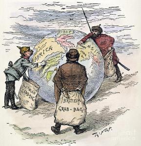
What is Imperialism?
when one nation is able to control other, usually smaller or weaker, nations
loyalty and devotion to a nation especially as expressed in a glorifying of one nation above all others
shared or governmental ownership and administration of the means of production and distribution of goods
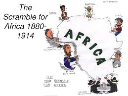
The scramble for Africa can be described as.......
fighting for natural resources and land in Africa
spreading religion
establishing new trade routes
Europeans working together to get new African trade routes
Artificial political boundaries are....
boundaries made by Europeans that ignored historical and ethnic borders
boundaries made by Europeans that follow along rivers and mountains
boundaries made by Africans that properly divided ethnic groups
boundaries made by Africans that separated ethnic groups and put rival ethnic groups together

The conditions described in the excerpt are most likely a result of the legacy of -
racial policies in South Africa
tribal division in South Africa
government corruption in South Africa
poor economic decision in South Africa
English and French have become common languages spoken in Sub-Saharan Africa because of -
a history of European colonization in the region
the migration of many missionaries to the region
a tradition of learning multiple languages in the region
an established system of Christian schools in the region
In what way did the European colonization of Sub-Saharan Africa affect economic development in the region?
Most economies primarily export natural resources.
Command economies became a common institution.
Traditional economies were encouraged to continue.
Industrial economies were established in most nations.
Many conflicts in Sub-Saharan Africa resulted from the way the European colonists -
mined the region for resources
educated different ethnic groups
distributed farmland amongst the settlers
established boundary lines between nations
How has the history of Sub-Saharan Africa contributed to political instability in some nations of the region?
The devastation of the WWII has left some nations struggling to recover.
The end of foreign aid to the region is leaving many without proper food and medicine.
The end of European colonization left some nations struggling to form effective governments.
The migration of the Bantu-speaking people across national boundaries has caused a clash of cultures.
The early civilizations of Africa were great empires. Their location along waterways allowed for their wealth and power to increase. Which of these was easier for them to do because of their location along waterways?
hunting
religion
trade
industry

True or False?: European countries failed to consider differences in ethnic groups, cultures, and political traditions when making artificial political borders in Africa.
True
False

In what way did European colonization of Sub-Saharan Africa affect economic development in the region?
Command economies became a common institution.
Traditional economies were encouraged to continue.
Industrial economies were established in most nations.
Most economies primarily export natural resources.

In what way did physical geography affect the language patterns of Sub-Sahara Africa?
Mountain ranges stopped the spread of languages across the continent.
Deserts and oceans served as barriers to the spread of some language families.
Languages were able to spread from islands in the Indian Ocean to Africa's mainland.
River systems in Africa helped to spread languages from South Africa to North Africa.
A major factor in the development of 20th–century nationalist movements throughout Africa was a common
language throughout most of Africa
goal to end European rule in Africa
ethnic bond among the people of
sub-Saharan Africa
religion throughout most of Africa
One way in which apartheid in South Africa and the caste system in India are similar is that both systems
allowed for educational opportunities
determined roles based on gender
revolved around central religious beliefs
enforced different sets of rules for distinct groups of people
Which country is most closely associated with the terms pass laws, homelands, and white minority rule?
El Salvador
South Africa
Iran
Israel
One characteristic of apartheid, which was practiced in South Africa, is
forced migration of blacks to other nations
integration of all races in society
an open immigration system
segregation of the races

Nelson Mandela was imprisoned for 27 years because he protested apartheid.
true
false
Why was Mandela an important person in South Africa?
because he defended human rights
because he was the first black President in South Africa
because he protested against the apartheid in South Africa
all of the above

What is apartheid?
a policy that brings together/integrates white and nonwhite people
a policy that keeps white and nonwhite people separated/ segregated
a policy that Nelson Mandela supported

