
NEW
Font size
 Worksheets
Surface Processes Review
Total questions: 64
Worksheet time: 53mins

While hiking in a region known for its glacial history, you come across an elongated hill composed of mixed glacial deposits. This feature is known as a...
kettle lake
moraine
sand dune
drumlin

🧊✨ Imagine you're part of a scientific team on a field study, observing the dynamic processes through which glaciers shape the Earth's surface. This series of captivating pictures captures the formation of which awe-inspiring glacial feature?
Moraine
Kettle Lake
Drumlin
Esker
While observing a landscape after a glacier has retreated, what is a major difference you would note between the materials deposited directly by the glacier (glacial till) and those deposited by meltwater (outwash)?
Glacial till is unsorted and unlayered, outwash is sorted and layered
Glacial till is sorted and unlayered, outwash is unsorted and layered
Glacial till is unsorted and layered, outwash is sorted and unlayered
Glacial till is sorted and layered, outwash is unsorted and unlayered

As a geologist studying the last Ice Age, you're analyzing the landscape and come across a series of smooth, elongated hills known as drumlins. These formations indicate the presence of a massive glacier in the past. Based on the orientation of these drumlins, can you infer the direction in which the glacier was moving?
From east to west
From south to north
From west to east
From north to south

What is the name for this large glacial boulder that does not match the surrounding sediments?
A drumlin
An erratic
A moraine
A kettle lake
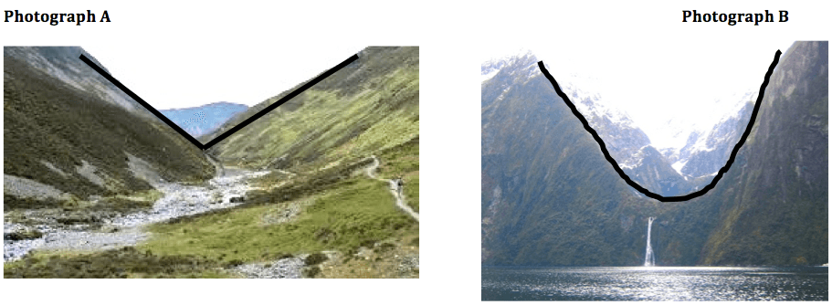
Which cross-section best represents the valley shape where a rapidly flowing stream is cutting into the bedrock in a mountainous area?


Which agent of erosion most likely produced this valley’s shape?
blowing wind
ocean waves
moving ice
running water
Which particle of quartz shows evidence of being transported the farthest distance by a stream?


Unsorted, angular, rough-surfaced cobbles and boulders are found at the base of a cliff. What most likely transported these cobbles and boulders?
running water
wind
gravity
ocean currents

Which rock layer appears to be most resistant to weathering and erosion?
Lockport dolostone
Rochester shale
Grimsby sandstone
Queenston shale
Sandstone, limestone, and conglomerate cobbles are found in a streambed in New York State where the surrounding bedrock is composed of shales and siltstones. The most likely explanation for the presence of these cobbles is that they were
weathered from the surrounding bedrock
formed when shale and siltstone bedrock were eroded
transported to this area from another region
metamorphosed from shale and siltstone

The diagram shows a process called frost wedging. Frost wedging is an example of
weathering
cementing
metamorphism
deposition
A meandering stream deposits most of its sediments on the
inside of meanders where the stream flows faster
inside of meanders where the stream flows slower
outside of meanders where the stream flows faster
outside of meanders where the stream flows slower
Which agent of erosion most likely formed the drumlins and finger lakes in New York State?
running water
moving ice
wave action
mass movement
Which statement best describes sediments deposited by glaciers and rivers?
Glacial deposits and river deposits are both sorted.
Glacial deposits are sorted, and river deposits are unsorted.
Glacial deposits are unsorted, and river deposits are sorted.
Glacial deposits and river deposits are both unsorted.
As a quartz pebble is transported by a stream, the pebble will become more rounded as a result of
dissolving as water is running over the rock
abrasion by colliding with other rocks
deposition in well-sorted layers
resistance to weathering and erosion

The diagram represents a side view of a hill (drumlin) that was deposited by a glacier. This hill is most likely composed of
cemented sediments
unsorted sediments
vertically layered sediments
horizontally layered sediments

Which type of weathering was primarily responsible for the development of these caves?
physical weathering of sandstone
physical weathering of limestone
chemical weathering of sandstone
chemical weathering of limestone
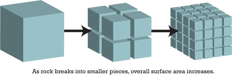
Which block will weather the fastest?
The left block
The middle block
The right block

At which two locations would the stream most likely be the deepest?
A and B
B and C
C and D
D and A

On which depositional feature is location X found?
an island arc
a barrier island
a drumlin
a floodplain

Which statement best describes the physical weathering shown by the diagram?
Enlargement of the cracks occurs because water expands when it freezes
This type of weathering occurs only in bedrock composed of granite
The cracks become wider because of chemical reactions between water and the rock
This type of weathering is common in regions of primarily warm and humid climates
Which event is an example of chemical weathering?
rocks falling off the face of a steep cliff
feldspar in granite being crushed into clay-sized particles
water freezing in cracks in a roadside outcrop
acid rain reacting with limestone bedrock
Landscapes will undergo the most chemical weathering if the climate is
cool and dry
cool and wet
warm and dry
warm and wet
A landslide is an example of
river deposition
glacial scouring
mass movement
chemical weathering
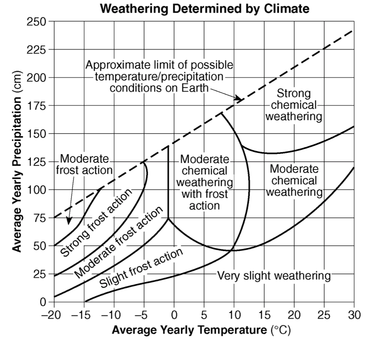
The amount of chemical weathering will increase if
air temperature decreases and precipitation decreases
air temperature increases and precipitation decreases
air temperature decreases and precipitation increases
air temperature increases and precipitation increases
Which agent of erosion is most likely responsible for the deposition of sandbars along ocean shorelines?
glaciers
mass movement
wave action
wind action

The accompanying cross section illustrates the general sorting of sediment by a river as it flows from a mountain to a plain. Which factor most likely caused the sediment to be sorted in the pattern shown?
velocity of the river water
hardness of surface bedrock
mineral composition of the sediment
temperature of the water
A sedimentary particle is dropped into a cylinder of water. The particle will take the longest time to settle if the particle has
low density, small size, and spherical shape
low density, small size, and flattened shape
high density, large size, and spherical shape
high density, large size, and flattened shape
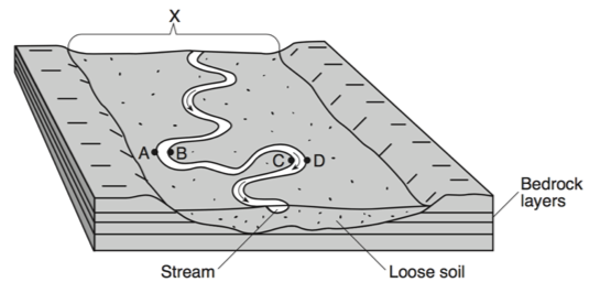
The landscape feature labeled X is best described as
a flood plain
a sand bar
a delta
an escarpment

When two meanders meet, and the river is redirected, the resulting formation is called
an oxbow lake
a drumlin
a delta
an outwash plain
Which type of climate has the greatest amount of rock weathering caused by frost action?
a dry climate in which temperatures remain below freezing
a dry climate in which temperatures alternate from below freezing to above freezing
a wet climate in which temperatures remain below freezing
a wet climate in which temperatures alternate from below freezing to above freezing

The block diagram represents a landscape where caverns and sinkholes have gradually developed over a long period of time. Which type of weathering was primarily responsible for the development of these caves?
physical weathering of sandstone
physical weathering of limestone
chemical weathering of standstone
chemical weathering of limestone
Water is a major agent of chemical weathering because water
has a density of about one gram per cubic centimeter
cools the surroundings when it evaporates
dissolves many of the minerals that make up rocks
has the highest specific heat of all common earth materials
What are the two things that affect the rate of weathering?
rain and ice
type of rock and climate
time and date
size of rock and time of the year

The photograph shows scratched and grooved
bedrock with boulders on its surface. The scratches and grooves were most likely created when
alternating thawing and freezing of water cracked the bedrock
flooding from a nearby lake covered the bedrock
a glacier dragged rocks over the bedrock
rocks from a landslide slid along the bedrock

The diagram shows sand particles being moved by wind. At which Earth surface locations is this process usually the most dominant type of erosion?
deserts an beaches
deltas and floodplains
glaciers and moraines
mountain peaks and escarments
Which profile best shows the general depositional pattern that occurs when water from a stream enters
the ocean?


The map shows a stream. Letters A, B, C, and D represent locations on the stream surface. Arrows represent the direction of stream flow. Which two locations have the greatest stream velocities?
A and B
B and C
C and D
D and A
Which agent of erosion is most likely responsible for the deposition of sandbars along ocean shorelines?
glaciers
mass movement
wave action
wind action

Base your answer on the block diagram and on your knowledge of Earth science. The diagram represents a meandering stream flowing into the ocean. Points A and B represent locations along the streambanks. Letter C indicates a triangular-shaped depositional feature where the stream enters the ocean. Identify the triangular-shaped depositional feature indicated by letter C.
flood plain
delta
erratic
oxbow lake

When talking about weathering, what does the word composition mean?
what the rock is made of
how long it takes to weather
It has nothing to do with weathering
temperature change
The formation of soil is primarily the result of
stream erosion and mass movement
stream deposition and runoff
precipitation and wind erosion
weathering and biological activity
What are two major factors that control the development of soil in a given location?
vegetative cover and slope
tectonic activity and elevation
erosion and transpiration
bedrock composition and climate
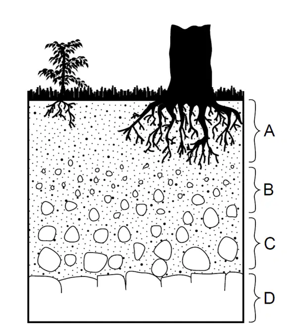
The cross section below represents zones of soil labeled A, B, and C. Letter D represents underlying bedrock. Which letter identifies the zone having the most organic and weathered material?
A
B
C
D

The sand dune was formed by-
Water
Ice
Wind
Snow

What type of erosion create the structure in the picture?
wind erosion
water erosion
glacial erosion
mass wasting
Glacial till is ____________
Sorted and Layered sediments deposited by glacial outwash
Unsorted and unlayered sediments deposited by glacial ice.
Oval shaped deposit that provides information on the direction of motion for a glacier.
Small lake left behind by a frozen block of buried ice melting

This land form was most likely formed by __________.
the movement of wind
the movement of water
the movement of a glacier
the movement of a tornado

These rocks were broken apart from the continuous freeze/thaw of water in the cracks of the rocks. This is an example of:
Frost wedging
acid rain
permeability
abrasion
An Outwash Plain is deposited by ___________.
glacial ice and is unsorted/unlayered
glacial ice and is sorted/layered
glacial meltwater and is unsorted/unlayered
glacial meltwater and is sorted/layered


_____ are long ridges (piles) of unsorted & unlayered sediment deposited at front end or along sides of glaciers.
Eskers
Till
Erratics
Moraines
The photograph shows scratched and grooved
bedrock with boulders on its surface. The scratches and grooves were most likely created when
alternating thawing and freezing of water cracked the bedrock
flooding from a nearby lake covered the bedrock
a glacier dragged rocks over the bedrock
rocks from a landslide slid along the bedrock

Which agent of erosion most likely formed these barrier islands?
mass movement
wave action
streams
glaciers
The movement of material along a coast by waves that approach at an angle to the shore but recede directly away from it.
swash
storm surge
longshore drift
breakwater

What are the features at letter B?
Terminal moraine
Groin
Breakwater
Seawall
Jetties are an effective technique because they stop the process of what from occurring?
Transportation
Longshore drift
Nearshore drift
Deposition

The diagram above shows the sequence of events leading to the deposition of landslide debris. What was the primary force that caused this landslide?
gravity
moving ice
prevailing wind
stream discharge
The natural sandblasting (abrasion) of surface bedrock in a desert region is the result of
wind erosion
wave erosion
mass movement
chemical precipitation
Unsorted, angular, rough-surfaced cobbles and boulders are found at the base of a cliff. What most likely transported these cobbles and boulders?
running water
wind
gravity
ocean currents
Which sediment is most easily picked up and transported by the wind?
cobbles
pebbles
sand
silt

