
 Worksheets
Plate Tectonics, Earthquakes, and Volcanoes Test
Total questions: 76
Worksheet time: 38mins
Name
Class
Date
1.
The German scientist Alfred Wegener proposed a theory that is called _____ that said the continents were once all joined as a single landmass called Pangaea.
a)
Paleomagnetism
b)
Continental Drift
c)
Floating Continents
d)
Seafloor Spreading
2.
The process in which new crust is formed that verified Alfred Wegener's theory of continental drift is
a)
geomagnetic reversal
b)
magnetic symmetry
c)
subduction
d)
seafloor spreading
3.
Which evidence does NOT support the theory that Africa and South America were once part of the same large continent?
a)
correlation of coastlines on opposite sides of the Atlantic Ocean
b)
correlation of living animals on opposite sides of the Atlantic Ocean
c)
correlation of rocks on opposite sides of the Atlantic Ocean
d)
correlation of fossils on opposite sides of the Atlantic Ocean
4.
Wegener's theory of continental drift was rejected because
a)
he did not have any evidence
b)
he could not prove what force caused continents to move
c)
he found fossils of Mesosaurs on mutiple continents
d)
he had too much evidence
5.
The two types of crust are
a)
oceanic and volcanic
b)
oceanic and transform
c)
volcanic and continental
d)
continental and oceanic
6.
During the process of seafloor spreading at the mid-ocean ridge
a)
old crust is destroyed
b)
crust goes into the trenches
c)
new crust is formed
d)
the less dense plate melts into the mantle
7.
During the process of subduction at the trench
a)
old crust is destroyed
b)
continental crust goes under oceanic crust
c)
new crust is formed
d)
the lighter plate melts into the mantle
8.
Tectonic plates are huge pieces of
a)
lithosphere/crust
b)
mantle
c)
core
d)
asthenosphere
9.
The process that involves magma being heated from the core, cooling as it rises and then sinking back down is called what?
a)
radiation
b)
convection
c)
conduction
d)
perspiration
10.
To get a sample of material from the mantle, drilling will be done through the oceanic crust rather than through the continental crust because oceanic crust is
a)
younger than continental crust
b)
less dense than continental crust
c)
thinner than continental crust
d)
softer than continental crust
11.
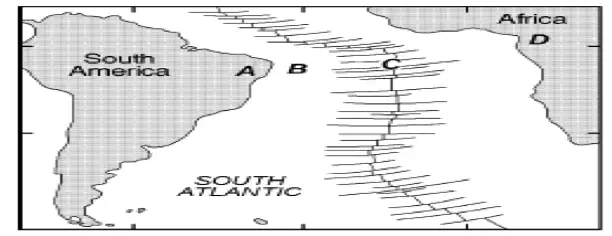
The map below shows the continents of Africa and South America, the ocean between them, and the ocean ridge and transform faults. Locations A and D are on the continents. Locations B and C are on the ocean floor. Which table best shows the relative densities of the crustal bedrock at locations A, B, C and D?
a)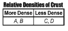
Option 1
b)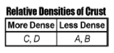
Option 2
c)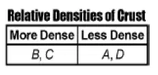
Option 3
d)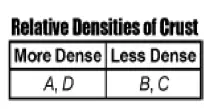
Option 4
12.
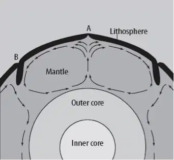
What type of plate boundary is occurring at point A in the diagram?
a)
Reverse
b)
Divergent
c)
Convergent
d)
Transform
13.
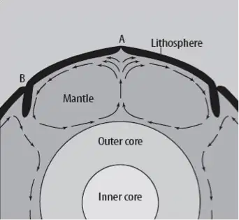
What type of plate boundary is occurring at point B in the diagram?
a)
Reverse
b)
Divergent
c)
Convergent
d)
Transform
14.
When a continental crustal plate collides with an oceanic crustal plate, the continental crust is forced to move over the oceanic crust. What is the primary reason that the continental crust stays on top of the oceanic crust?
a)
continental crust deforms less easily
b)
continental crust is less dense
c)
continental crust melts at higher temperatures
d)
continental crust contains more mafic minerals
15.
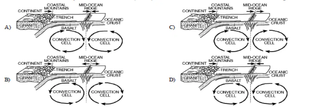
The diagrams below shows some features of Earth's crust and upper mantle. Which model most accurately shows the movements (arrows) associated with the surface features shown in the diagram?
(a)
16.
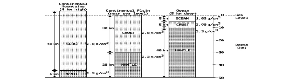
The diagram below represents three cross sections of the Earth at different locations to a depth of 50 km below sea level. The measurements given with each cross section indicate the thickness and the density of the layers. The thinnest section of Earth's crust can be found beneath:
a)
coastal plains
b)
desert regions
c)
mountain ranges
d)
oceans
17.
The movement of crustal plates is most likely caused by
a)
the revolution of the Earth
b)
the erosion of Earth's crust
c)
shifting of the Earth's magnetic poles
d)
convection currents in Earth's mantle
18.
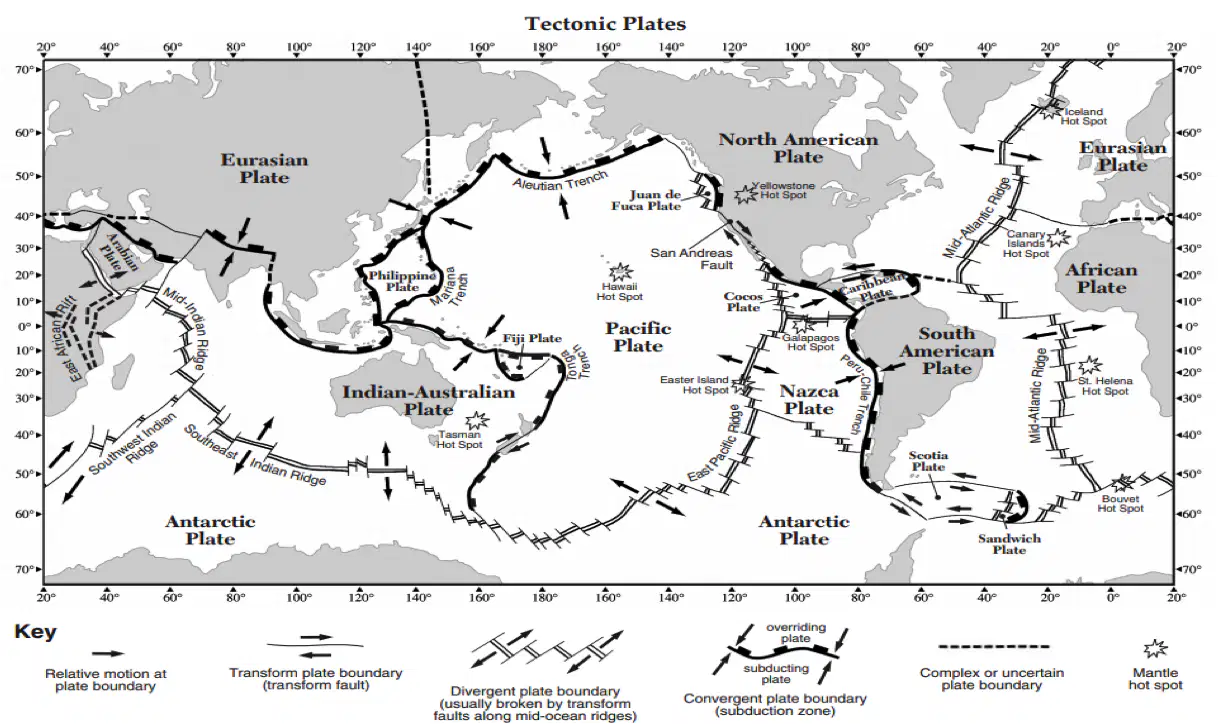
What geologic formation is located at (32N, 18W)?
a)
Canary Islands Hot Spot
b)
Hawaiian Islands Hot Spot
c)
Mid-Atlantic Ridge
d)
East African Rift Valley
19.

What type of plate boundary occurs between the Nazca Plate and the South American Plate?
a)
Divergent
b)
Convergent
c)
Transform
d)
Complex/Uncertain
20.

What two plates are involved at the Mariana Trench convergent boundary?
a)
Philippine and Pacific
b)
Philippine and Indian-Australian
c)
Eurasian and Philippine
d)
Indian-Australian and Pacific
21.
Some early mapmakers thought that the coastline of South America matched the coastline of Asia.
a)
True
b)
False
22.
Scientists at the time rejected Wegener's theory of continental drift because he could not explain how or why Earth's continents moved.
a)
True
b)
False
23.
Wegener's theory of plate tectonics stated that Earth's continents had once been joined as a single landmass.
a)
True
b)
False
24.
The Theory of Plate Tectonics states that Earth's crust and rigid upper mantle (lithosphere) are broken into enormous pieces called tectonic plates that move slowly over Earth's surface.
a)
True
b)
False
25.
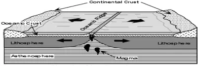
Check the boxes that indicate the type of boundary, direction of movement and resulting geologic feature for the image provided. (3 boxes should be checked)
a)
Divergent
b)
Away
c)
Mid-Ocean Ridge
d)
Convergent
e)
Transform
26.
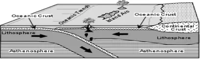
Check the boxes that indicate the type of boundary, direction of movement and resulting geologic feature for the image provided. (3 boxes should be checked)
a)
Convergent
b)
Towards
c)
Trench/Volcanic Islands
d)
Divergent
e)
Transform
27.
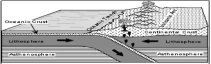
Check the boxes that indicate the type of boundary, direction of movement and resulting geologic feature for the image provided. (3 boxes should be checked)
a)
Convergent
b)
Towards
c)
Trench/Volcanic Mountains
d)
Divergent
e)
Transform
28.
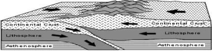
Check the boxes that indicate the type of boundary, direction of movement and resulting geologic feature for the image provided. (3 boxes should be checked)
a)
Convergent
b)
Towards
c)
Mtn Range
d)
Divergent
e)
Transform
29.
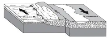
Check the boxes that indicate the type of boundary, direction of movement and resulting geologic feature for the image provided. (3 boxes should be checked)
a)
Transform
b)
Sliding
c)
Fault Line
d)
Convergent
e)
Divergent
30.
Volcanoes that form over hot spots are often solitary and close to tectonic plate boundaries.
a)
True
b)
False
31.
The Hawaiian Islands formed as the result of the Pacific Plate moving over hot spots in Earth's mantle.
a)
True
b)
False
32.
Earthquakes do not generally kill people, the effects from earthquakes (I.e. falling buildings) do.
a)
True
b)
False
33.
The San Andreas Fault is the only active fault in the United States.
a)
True
b)
False
34.
The location within Earth where the first motion of an earthquake occurs is called a(n)
a)
Epicenter
b)
Seismic
c)
Focus
d)
Shadow
35.
When rocks along a fault slip into new positions, they release energy in the form of vibrations called
a)
Tidal Waves
b)
Elastic Waves
c)
Seismic Waves
d)
Focus Waves
36.
What is the epicenter of an earthquake?
a)
The location along a fault where the first motion of an earthquake occurs
b)
A seismic wave that travels along the surface of Earth
c)
The point on Earth’s surface directly above the earthquake’s focus
d)
A seismic wave that is the most damaging
37.
What happens to tsunamis as they move toward the shore?
a)
They decrease in height
b)
They die out
c)
They turn into riptides
d)
They increase in height
38.
Which of the following would be an important warning sign of volcanic activity?
a)
A change in local wind patterns
b)
A bulge in the surface of the volcano
c)
A decrease in seismic activity
d)
A decrease in local temperatures
39.
As you increase the amount of gas in magma, the explosively
a)
increases
b)
decreases
c)
stays the same
d)
gas has nothing to do with explosively
40.
As you increase the temperature of a substance, the viscosity will
a)
increase
b)
decrease
c)
increase briefly then decrease
d)
temperature has no effect on viscosity
41.
If a volcano's magma is high in silica, the volcano will probably
a)
Erupt quietly
b)
Remain Dormant
c)
Erupt explosively
d)
Produce dark colored lava
42.
What provides the force that powers volcanic activity?
a)
motion of magma in the mantle
b)
minerals present
c)
gravity in the lithosphere
d)
the viscosity of the lava
43.
Before lava reaches the surface, the molten material is called
a)
rock
b)
magma
c)
volcanic ash
d)
liquid fire
44.
What is the minimum number of seismograph stations required in order to determine the exact location of an earthquake's epicenter?
a)
one
b)
two
c)
three
d)
four
45.
What does a seismograph record?
a)
the Mercalli scale rating for an earthquake
b)
the speed of seismic waves
c)
the ground movements caused by seismic waves
d)
the location of the epicenter
46.
In what direction do seismic waves carry the energy of an earthquake?
a)
Away from the focus
b)
Toward the focus
c)
From the surface to the interior
d)
Through the mantel only
47.
Which of the following is NOT a danger from a volcanic eruption?
a)
Volcanic summer
b)
Loss of land
c)
Pyroclastic Flow
d)
Volcanic Bombs
48.
The San Andreas Fault is actually a transform plate boundary. Which of the following diagrams correctly shows how the plates are moving in the San Andreas fault area?
a)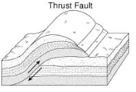
A
b)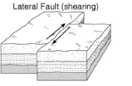
B
c)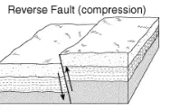
C
d)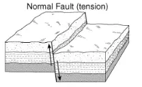
D
49.
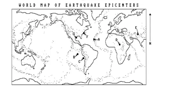
How would a map showing the location of active volcanoes compare to the map showing the location of earthquake epicenters in the picture?
a)
Only a small percentage of volcano locations would be in the same regions as the epicenters.
b)
the location of the volcanoes and the epicenters would only match in the ocean regions.
c)
A large percentage of volcano locations would be in the same regions as the epicenters.
d)
There would be no match between the locations of the volcanoes and epicenters.
50.
Where do most earthquakes occur?
a)
Randomly over the Earth's surface
b)
At the plate boundaries
c)
In the continental interiors
d)
At the mantle-core boundary
51.
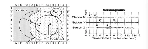
The diagram shows three seismograms of the same earthquake recorded at three different seismic stations, X, Y, and Z. The distances from each seismic station to the earthquake epicenter have been drawn on the map. A coordinate system has been placed on the map to describe locations. On the map, which location is closest to the epicenter of the earthquake?
a)
E-5
b)
G-1
c)
H-8
d)
H-3
52.
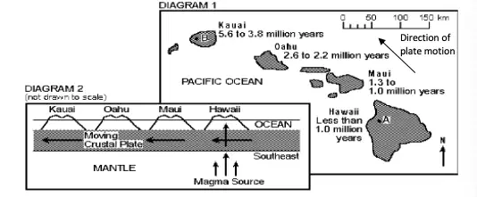
Diagram 1 below is a map showing the location and bedrock age of some of the Hawaiian Islands. Diagram 2 is a cross section of an area of the Earth illustrating a stationary magma source and the process that could have formed the islands. Which of the Hawaiian Islands has the greatest probability of having volcanic eruption?
a)
Oahu
b)
Hawaii
c)
Kauai
d)
Maui
53.
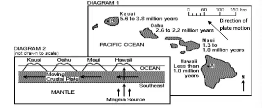
Diagram 1 below is a map showing the location and bedrock age of some of the Hawaiian Islands. Diagram 2 is a cross section of an area of the Earth illustrating a stationary magma source and the process that could have formed the islands. If each island formed as the crustal plate moved over the magma source in the mantle as shown in the diagram, where would the next volcanic island most likely form?
a)
Southeast of Hawaii
b)
Northwest of Hawaii
c)
Northeast of Hawaii
d)
Between Hawaii and Maui
54.
Rates earthquake intensity
a)
modified Mercalli scale
b)
magnitude
c)
stress
d)
fault
e)
tsunami
55.
Wave generated by vertical motions of the seafloor
a)
tsunami
b)
modified Mercalli scale
c)
magnitude
d)
stress
e)
fault
56.
Seismic wave that causes the ground to move in two directions
a)
surface wave
b)
modified Mercalli scale
c)
magnitude
d)
stress
e)
fault
57.
Forces per unit area acting on a material
a)
stress
b)
modified Mercalli scale
c)
magnitude
d)
fault
e)
tsunami
58.
Measure of the energy released by an earthquake
a)
magnitude
b)
modified Mercalli scale
c)
stress
d)
fault
e)
tsunami
59.
Deformation of materials in response to stress
a)
strain
b)
modified Mercalli scale
c)
magnitude
d)
stress
e)
fault
60.
Fracture in rock along which movement occurs
a)
fault
b)
modified Mercalli scale
c)
magnitude
d)
stress
e)
tsunami
61.
Shield Volcano
a)
Tallest type of volcano, explosive, most dangerous, Mt. St. Helens
b)
Explosive and non-explosive eruptions, steep sides, smallest, Mt. Lassen
c)
Largest type of volcano, gentle slopes, quiet eruptions, Moana Loa
62.
Composite Volcano
a)
Tallest type of volcano, explosive, most dangerous, Mt. St. Helens
b)
Explosive and non-explosive eruptions, steep sides, smallest, Mt. Lassen
c)
Largest type of volcano, gentle slopes, quiet eruptions, Moana Loa
63.
Cinder-Cone Volcano
a)
Tallest type of volcano, explosive, most dangerous, Mt. St. Helens
b)
Explosive and non-explosive eruptions, steep sides, smallest, Mt. Lassen
c)
Largest type of volcano, gentle slopes, quiet eruptions, Moana Loa
64.
Rhyolitic Magma
a)
Intermediate Silica Content, Intermediate viscosity, quiet or loud eruptions
b)
Low silica content, low viscosity quiet eruptions, pahoehoe and Aa lava
c)
High silica content, high viscosity, explosive eruptions
65.
Andesitic Magma
a)
Intermediate Silica Content, Intermediate viscosity, quiet or loud eruptions
b)
Low silica content, low viscosity quiet eruptions, pahoehoe and Aa lava
c)
High silica content, high viscosity, explosive eruptions
66.
Basaltic Magma
a)
Intermediate Silica Content, Intermediate viscosity, quiet or loud eruptions
b)
Low silica content, low viscosity quiet eruptions, pahoehoe and Aa lava
c)
High silica content, high viscosity, explosive eruptions
67.
Measures earthquake magnitude on a scale of 1-10
a)
Richter Scale
b)
Seismology
c)
Seismograph
d)
Seismogram
e)
Surface Waves
68.
The Second faster seismic wave; causes particles of rock to move in an up and down motion
a)
S-waves
b)
Seismology
c)
Seismograph
d)
Seismogram
e)
Richter Scale
69.
Diagram of earthquake waves
a)
Seismogram
b)
Seismology
c)
Seismograph
d)
Richter Scale
e)
Surface Waves
70.
A seismic wave that travels along the surface of the Earth
a)
Surface Waves
b)
Seismology
c)
Seismograph
d)
Seismogram
e)
Richter Scale
71.
The fastest seismic wave; causes particles of rock to move back and forth
a)
P-waves
b)
Seismology
c)
Seismograph
d)
Seismogram
e)
Richter Scale
72.
An instrument used for detecting and recording vibrations in the ground
a)
Seismograph
b)
Seismology
c)
Seismogram
d)
Richter Scale
e)
Surface Waves
73.
The study of earthquake waves
a)
Seismology
b)
Seismograph
c)
Seismogram
d)
Richter Scale
e)
Surface Waves
74.
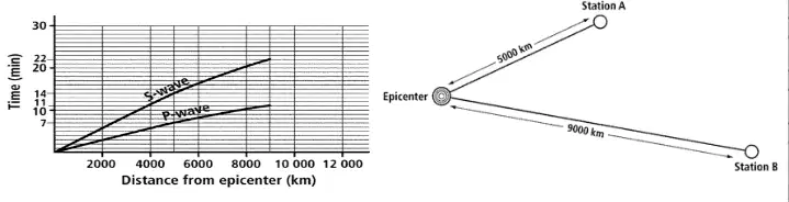
An earthquake occurred and seismic waves were detected by stations A and B as shown below. Examine the diagram and the travel-time graph. About how long did it take for the first P-waves to reach station A?
a)
5 minutes
b)
7 minutes
c)
10 minutes
d)
14 minutes
75.
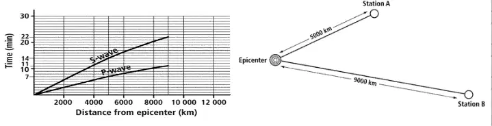
An earthquake occurred and seismic waves were detected by stations A and B as shown below. Examine the diagram and the travel-time graph. About how long did it take for the first S-waves to reach station A?
a)
5 minutes
b)
7 minutes
c)
10 minutes
d)
14 minutes
76.
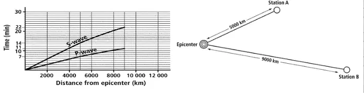
An earthquake occurred and seismic waves were detected by stations A and B as shown below. Examine the diagram and the travel-time graph. About how long did it take for the first P-waves to reach station B?
a)
5 minutes
b)
7 minutes
c)
10 minutes
d)
14 minutes
100 %

