
 Worksheets
XMas Term SOCIAL STUDIES Quiz - Part 1
Total questions: 60
Worksheet time: 35mins
What is geography mostly about?
Studying ancient myths
Reading stories from different cultures
Learning only about people
The study of people, places and the environment
Why is geography important?
It helps us understand where things are, why they are there, and how they affect our lives
It mainly teaches us how to predict the weather.
It is mostly about maps and directions.
It focuses only on landforms and oceans.
In the word “geography,” what does “geo” mean?
People
Earth
Maps
Study
In the word “geography,” what does “graphy” mean?
Water
Map
To write about or study
People
Which of the following are the main branches of geography?
Biology and Chemistry
Physical Geography and Human Geography
Oceanography and Astronomy
History and Literature
What is the main difference between human geography and physical geography?
Human geography studies maps; physical geography studies history.
Human geography studies rocks and rivers; physical geography studies cities and governments.
Human geography studies people, cultures, and communities; physical geography studies landforms, water, weather, and nature.
Human geography studies animals; physical geography studies plants.
Climatology and meteorology fall under which branch of geography?
Human Geography
Physical Geography
Cultural Geography
Economic Geography
Which of the following are areas of human geography?
Mountains, rivers, and oceans
Population, cultural, and economic
Volcanoes, earthquakes, and tsunamis
Weather, climate, and seasons
Which of the following lists the Five Themes of Geography?
History, Science, Math, Reading, Art
Latitude, Longitude, Mountains, Rivers, Cities
Continents, Oceans, Climate, Maps, Culture
Location, Place, Movement, Region, Human-Environment Interaction
What are the two types of location in geography?
North and South
Absolute and Relative
Urban and Rural
Physical and Cultural
Which option correctly shows the right examples for Place, Human-Environment Interaction, Movement, and Region?
Place → Africa
Human-Environment Interaction → The Pacific Ocean
Movement → Mountains and rivers
Region → 48.8584° N, 2.2945° E
Place → Eiffel Tower in Paris
Human-Environment Interaction → People build dams and cities
Movement → Goods and people traveling between countries
Region → The Sahara Desert
Place → Europe
Human-Environment Interaction → Forests
Movement → Schools and hospitals
Region → Paris
Place → Europe
Human-Environment Interaction → Forests
Movement → Schools and hospitals
Region → Paris
Which of the following is an example of absolute and relative location?
Absolute: 48.8584° N, 2.2945° E; Relative: In the center of Paris, near the Seine River
Absolute: Near the Eiffel Tower; Relative: 48.8584° N, 2.2945° E
Absolute: In Paris; Relative: In France
Absolute: Europe; Relative: Northern Hemisphere
Choose a Bahamian island and describe its unique features using the five themes of geography.
How were maps used in the distant past?
They were chiseled on stone
They were drawn in dirt
They were carved in the bark of trees
All of the above
What is a World Map?
A drawing that shows only the countries in one continent
A map that shows the entire Earth’s surface
A map of North and South America
A map that shows only oceans and no land
What is a Globe?
A flat drawing of a neighborhood
A tool used to measure distance
A map that shows only one continent
A ball-shaped model of the Earth
What do you call a person who draws maps to scale?
Maptologist
Historian
Cartographer
Globologist
Which option correctly matches the profession with what they do using maps?
Land Surveyor – designs parks and recreational areas
• Architect – guides hikers using maps
• Teacher – maps out property lines
Land Surveyor – teaches students about cities and countries
• Architect – draws political boundaries only
• Teacher – measures land for building projects
Land Surveyor – measures and maps land for construction or property boundaries
• Architect – designs buildings and plans using maps for layouts
• Teacher – uses maps to teach geography and social studies
Land Surveyor – creates weather maps
• Architect – measures rivers and mountains
• Teacher – builds roads and bridges
Which book has a collection of maps?
Encyclopedia
Atlas
Dictionary
Bible
What is one key difference between a map and a globe?
A map changes shape when rotated, while a globe stays the same shape.
A map always shows the entire world, while a globe only shows continents.
A map shows Earth’s features on a flat surface, while a globe represents Earth as a sphere.
A map is three-dimensional, while a globe is flat.
True or False
A Globe shows accurate size, shape and distances of places on earth, but a map does not.
true
false
Which option correctly lists all the parts commonly found on a map?
Title, inset, compass rose, scale, legend, latitude bands, distance markers
Title, border, inset, compass rose, scale, legend, grid lines
Border, grid lines, inset, orientation arrow, elevation key, scale
Title, compass rose, border, landforms key, scale bar, coordinate boxes
What part of the map tells you what it is about?
Inset
Grid lines
Legend
Title
What does the border of a map show you?
The height and shape of the land
The symbols used to explain features
The boundaries of places shown on the map
The direction of north and south
What is the purpose of an inset on a map?
To show a smaller or zoomed-in map inside the larger map
To show the directions
To display the meaning of symbols
To measure elevation and land height
What is the purpose of a scale on a map?
To show which direction is north
To show how distances on the map related to real-world distances
To identify the symbols used on the map
To compare sizes of different landforms
If a location has the grid reference B4, what does that mean?
The place is found at column B and row 4 on the grid
The place is 4 km from point B
The place is the 4th city in area B
The place is at 4° latitude
What is the difference between a word (verbal) scale and a bar (linear) scale on a map?
A word scale represents distances using proportional circles, while a bar scale uses a straight line
A word scale shows distances numerically only, while a bar scale uses both numbers and symbols
A word scale uses words to describe distances (e.g., “1 cm = 10 km”), while a bar scale is a graphic line showing distances visually
A word scale measures elevation or relief, while a bar scale measures distances
What are the correct steps for using a linear (bar) scale on a map?
Step 1 – Estimate the distance with your finger; Step 2 – Multiply by 10; Step 3 – Round to the nearest city
Step 1 – Place a paper or ruler between the two points; Step 2 – Mark the distance between the points on the map; Step 3 – Place the paper or ruler on the scale and read the distance
Step 1 – Draw a line between the points; Step 2 – Count the grid squares crossed; Step 3 – Ignore the scale
Step 1 – Measure only rivers; Step 2 – Convert to inches; Step 3 – Add 5 km to your answer
What is the legend on a map and what purpose does it serve?
It is a list of important cities shown on the map
It is the map key – a guide that explains symbols and colors on a map
It is a section that shows the climate of the region
It is a chart that compares the population of different areas
What is the Grid?
A set of intersecting lines that form squares which help locate places using coordinates
A key that explains symbols on the map
A smaller map inside a larger map
A scale that shows distances between places
What are the names of the grid lines on a map?
Equator and Prime Meridian only
Meridians and Tropics only
Latitude and longitude
Compass lines and borders
In which direction do lines of latitude run on a map?
East to west (horizontally)
North to south (vertically)
Diagonally from corner to corner
In circles around the poles only
What are lines of longitude also known as, and in which direction do they run?
Equators – around the middle of the Earth
Tropics – diagonally across the globe
Parallels – east to west (horizontally)
Meridians – north to south (vertically)
What do contour lines represent on a map?
The elevation or height of the land
Rivers and lakes only
Political boundaries between countries
Roads and highways
Which option shows the correct representation of contour lines?
Close lines → gentle slopes
Wide lines → steep slopes
Closed loops → rivers
V-shaped lines → hills
Close lines → steep slopes
Wide lines → gentle slopes
Closed loops → hills or mountains
V-shaped lines → valleys or rivers
Close lines → flat land
Wide lines → mountains
Closed loops → valleys
V-shaped lines → plateaus
Close lines → hills
Wide lines → cliffs
Closed loops → rivers
V-shaped lines → plains
What is one key difference between a map and an aerial photo?
A map always shows the entire world, while an aerial photo only shows countries
A map is a drawn or digital representation of an area, while an aerial photo is a real-life image taken from above
A map cannot show physical features, while an aerial photo only shows mountains and rivers
A map changes when rotated, while an aerial photo always stays the same size
What is another word for a map symbol, and what does it mean?
Marker – a tool used to draw on the map
Signal – a warning for travelers
Sign – something that represents something else
Indicator – a line showing direction
What are map symbols?
Names of cities and countries written on a map
Lines that show the borders between countries
Pictures, shapes, or colors used on a map to represent real-world features
Measurements of distance between two points on a map
Why are symbols important for maps?
They change the scale of the map depending on the area
They provide the latitude and longitude of every location
They show the exact size of objects on the ground
They allow map readers to understand and identify features quickly without lots of words
Which option correctly matches each map color with what it usually represents?
Red – cities
• Green/Purple – forests
• Brown – deserts
• Blue – sky
Red – political boundaries
• Green/Purple – farmland
• Brown – hills and mountains
• Blue – clouds
Red – main roads
• Green/Purple – land areas
• Brown/Yellow – highlands, mountains, or hills
• Blue – water features (rivers, lakes, oceans)
Red – highways
• Green/Purple – parks and fields
• Brown – cliffs and valleys
• Blue – sky
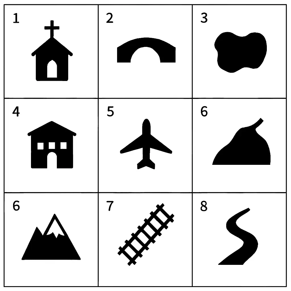
Which option correctly matches the map symbols with what they represent? (ignore 1st number 6)
1 – Church
2 – Bridge
3 – Lake
4 – School
5 – Airport
6 – Mountain
7 – Railroad
8 – River
1 – Temple
2 – Tunnel
3 – Pond
4 – Library
5 – Airport
6 – Hill
7 – Railroad
8 – Stream
1 – Chapel
2 – Overpass
3 – Reservoir
4 – Academy
5 – Airport
6 – Peak
7 – Railroad
8 – Waterfall
1 – Cathedral
2 – Road Crossing
3 – Lagoon
4 – College
5 – Airport
6 – Volcano
7 – Railroad
8 – Canal

On a map, what is represented by this symbol?
city/settlement
shopping mall
capital city
hospital

What does this symbol represent on a map?
lamp pole
road
stream
bridge
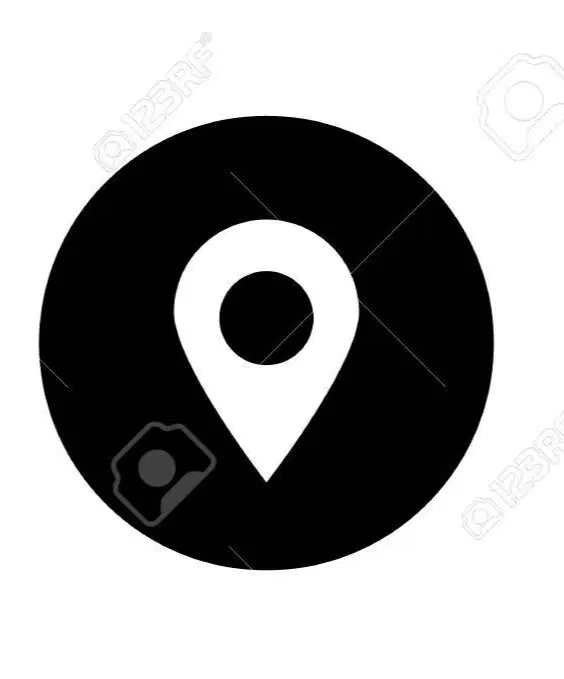
On a map, what does this symbol represent?
A city/settlement
Forest
Hospital
Train station
What would you see on a political map?
Climate zones and weather patterns
Land heights, mountains, and valleys
Country names, cities, capitals, and borders
Rivers, lakes, and natural landforms
What would you find on a physical map?
Climate types and weather patterns
Population density and economic activities
Country borders, capitals, and major cities
Landforms such as mountains, rivers, lakes, and plains
What is a contour or topographic map?
A map that shows countries, capitals, and borders
A map that shows the shape and height of the land using contour lines
A map that displays climate zones and temperature patterns
A map that shows roads, highways, and travel routes
What is a thematic map?
A map that shows only physical features like mountains and rivers
A map that displays political boundaries and capitals
A map that focuses on a specific topic or theme, such as population, climate, or resources
A map that shows roads, highways, and transportation routes
Why are physical maps sometimes called topographic maps?
Because they show country borders and cities
Because they sometimes show the shape and elevation of the land using contour lines
Because they focus on a specific theme or topic
Because they display roads and transportation networks
List 5 Thematic maps and what you would see on them.
What are the four cardinal points on a compass?
North, South, East, West
Northeast, Southeast, Southwest, Northwest
Up, Down, Left, Right
North, South, Northeast, Southwest
Which option correctly lists the four cardinal points and the four major intermediate points of the compass?
Up, Down, Left, Right, Northeast, Northwest, Southeast, Southwest
North, South, East, West, Northeast, Northwest, Southeast, Southwest
North, South, East, West only
Northeast, Northwest, Southeast, Southwest only
Which option correctly lists the 16 points of the compass?
North, South, East, West, Up, Down, Left, Right, Northeast, Northwest, Southeast, Southwest, Far North, Far South, Far East, Far West
North, East, South, West repeated four times
N, NNE, NE, ENE, E, ESE, SE, SSE, S, SSW, SW, WSW, W, WNW, NW, NNW
N, S, E, W, NN, SS, EE, WW, WN, SW, NW, EW, ES, NS, EN, SE
Each of the points on the compass has degrees of turn known as what?
Rotations
Directions
Headings
Bearings
What is the purpose of bearings?
To measure distances between two locations
To indicate accurate directions using degrees
To show elevation above sea level
To determine speed of travel
The large areas of land that divide the earth are called what?
Continents
Countries
Cities
Peninsula
How many Oceans surround the 7 continents?
5
7
9
6
Which of these is not a body of water that surrounds the seven continents?
Pacific Ocean
Atlantic Ocean
Indian Ocean
Arctic Ocean
Coral Ocean
African Ocean
Southern/ Antarctic Ocean
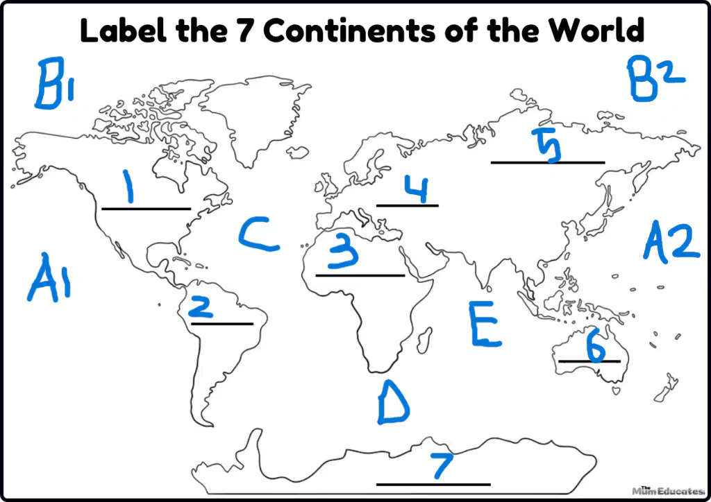
Which option correctly matches the bodies of water?
A1 – Atlantic Ocean
A2 – Pacific Ocean
B1 – Arctic Ocean
B2 – Indian Ocean
C – Pacific Ocean
D – Southern Ocean
E – Atlantic Ocean
A1 – Pacific Ocean
A2 – Pacific Ocean
B1 – Arctic Ocean
B2 – Arctic Ocean
C – Atlantic Ocean
D – Southern Ocean
E – Indian Ocean
A1 – Indian Ocean
A2 – Atlantic Ocean
B1 – Southern Ocean
B2 – Pacific Ocean
C – Arctic Ocean
D – Atlantic Ocean
E – Pacific Ocean
A1 – Arctic Ocean
A2 – Indian Ocean
B1 – Atlantic Ocean
B2 – Southern Ocean
C – Pacific Ocean
D – Pacific Ocean
E – Arctic Ocean

