
 Worksheets
Maps, Graphs, & Charts
Total questions: 78
Worksheet time: 46mins
AFRICA: How many miles does an inch equal on the Political
Relief Map of Southern Africa?
423 miles
600 miles
730 miles
820 miles
AFRICA: The land cover of the Congo Basin is mostly of what
type?
cropland
desert
tropical rain forest
tundra
AFRICA: How many miles is it from the capital of Uganda to
the capital of Somalia?
about 500 miles
about 700 miles
about 900 miles
about 1,100 miles
AFRICA: What is the main metal in the country of Nigeria?
oil
copper
nickel
tin
AFRICA: The largest country by population is in what area of
the continent?
eastern
northern
southern
western
AFRICA: What is the highest elevation in the country of Chad?
over 10,000 feet
5,000 to 10,000 feet
2,000 to 5,000 feet
1,000 to 2,000 feet
AFRICA: Which country does the Niger river not run through?
a. c.
b. d.
Mali
Egypt
Niger
Nigeria
AFRICA: The Great Rift Valley runs through which country?
Angola
Gabon
Mozambique
Niger
AFRICA: What is the main climate type found on Madagascar?
desert
savanna
steppe
tropical rain forest
AFRICA: How many capitals does the nation of South Africa
have?
0
1
2
3
AFRICA: What is the dominant land use in Angola?
commercial farming
forestry
nomadic herding
subsistence farming
AFRICA: What capital is just north of the largest lake on the
continent?
Cairo, Egypt
Bamako, Mali
Kampala, Uganda
Cape Town, South Africa
AFRICA: What percentage of the labor force in Niger is
involved in agriculture?
50%
75%
80%
90%
AFRICA: Which of the following has the highest population
growth?
Ethiopia
Niger
South Africa
the world
AFRICA: The longest continental mountain range crosses
which country?
Angola
Congo
Morocco
Niger

How many festival venues are indicated on the
map?
1
2
3
4
What do the gift box icons represent?
Christmas
vendors
birthday gifts
not indicated
What is the scale of the insert compared to the other
map?
4 to 1
10 to 1
20 to 1
not indicated

What does the dotted line represent?
state highway
city street
river
parking area
Which venue is the furthest south?
a. City Center
b. Festival Park
c. Morgan Art Center
d. University Park
Which venue is the furthest south?
a. City Center
b. Festival Park
c. Morgan Art Center
d. University Park

Where in Festival Park is the camping area located?
a. northeast corner
b. northwest corner
c. southeast corner
d. southwest corner
How many First Aid stations are shown on the map?
a. 1
b. 2
c. 3
d. 4

The International Date Line runs through what body of water?

Atlantic Ocean

Arctic Ocean

Indian Ocean

Pacific Ocean

The Arabian Peninsula is mainly made up of what type of land cover?
Cropland
Grassland
Semidesert and Desert
Tundra

Which of the following countries is not a leader in oil exports?

China

Saudi Arabia

Iraq

Russia

The word's coldest continually inhabited settlement is in what country?

Antarctica

China

Iceland

Russia

Which of the following cities is not on the Yangtze River
Chongquing
Hong Kong
Nanjing
Wuhan

The Persian Gulf lies between Saudi Arabia and what country?
Iran
Iraq
Oman
Yemen

What is the region's most densely populated country?
Indonesia
Malaysia
Japan
Singapore
The highest peak on the continent is in what country?
(a)

Buddhism is a predominant belief in which of the following?
China
India
Philippines
Thailand

Spratly Island is a territory of what country?
Japan
Russia
Turkey
Disputed
Which of the following is the largest urban area in Asia?

Muscat, Oman

Tokyo, Japan

New Delhi, India

Bangkok,
Thailand

Mount Everest is....
Sinking about 5 millimeters per year
Sinking about 2 millimeter per year
Growing about 5 millimeters per year
Growing about 2 millimeters per year
Tundra can be found in which of the following countries?
South Korea
Russia
Iran
Taiwan

Which of the following cities in Uzbekistan is the largest?
Jizzakh
Muynak
Tashkent
Samarqand

Which country's capital is closest to the equator?

Philippines

Maldives

Taiwan

Yemen

The pie chart shows the colours of 32 beads. How many green beads are there?
90
8
11
9

What is the maximum number of computers that someone said they had?
8
10
4
1
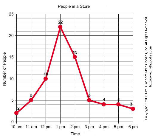

Which day of the week had the lowest temperature?
Monday
Thursday
Tuesday
Wednesday

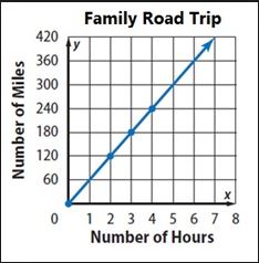
Based on the graph, Which of the following statements is TRUE?
I drove 80 miles every 4 hours
I drove 160 miles in an hour
I drove 80 miles every 2 hours
I drove 240 miles in 4 hours


What is the dependent variable on this graph?
Year
Number of Visitors
None of these

Mikey had two mice that were about the same age and weight. Mikey fed each of the two mice a different feed for a month. He measured how much the mice weighed every two days until the month was over. Mikey's results showed that although both mice gained weight over the month, mouse 2 gained more weight than mouse 1.Which graph below best shows these results?

Assuming that the population growth of the bacteria continues, what would be a good prediction for the number of bacteria cells that will exist in 140 minutes?
0
40
100
2000

What sport is the most popular?
Cricket
Rugby
Football
Cricket and netball

What is this graph showing you?
The world's population has been growing but the rate of growth is decreasing
The worlds population was growing but now is decreasing
The worlds population is staying the same

How many months were there more than 200 ice cream cones sold?
2
3
4
5

What was the highest temp. on Friday?
56*F
57*F
40*F
38*F


This is the coldest continent and also home of many penguins.
North America
Antarctica
South America
Europe
What graph is described?
In 1997 there were two equal sectors.


largest to smallest. -Jayapura,Indonesia ; Kalgoorlie, Australia and Quezon City, Philippines.
Palau is just under 1,000 miles.

