
Font size
 Worksheets
Earth & Space Practice Test 1
Total questions: 40
Worksheet time: 55mins



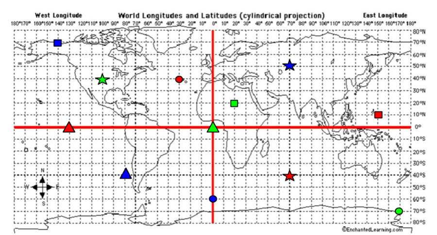
What are the coordinates for the RED Circle?
40*S, 70*E
40*N, 30*W
0*, 130*W
10*N, 150*E



Lines running East to West, measuring distance North or South of the Equator in Degrees.
Latitude
Longitude
Meridian
Parallel
Lines running North and South, measuring distance East or West of the Prime Meridian in degrees.
Latitude
Longitude
Meridian
Parallel
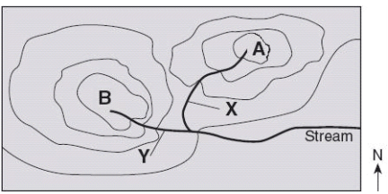


What is the contour interval of this map?
10
20
30
40



What is the contour interval on this map?
10
50
100
500

Lines on a map that separate colors on a relief map and show all points on the map that have the same altitude are called
meridians.
contour lines.
parallels.
gores.



Which side is steeper?
The left side of the hill
The right side of the hill

Match the topographic map to its profile.


Match the topographic map to its profile picture.


What is the elevation of point Z?
190 m
220 m
240 m
250 m

Which locations have the same elevation?
A and C
B and E
C and I
F and G

What is the elevation of point A on the topographic map?
1,700 ft
1,650 ft
1,600 ft
1,550 ft

A person walks along the trail from location C to location D. The person will be walking
downhill then uphill, only
downhill, then uphill, then downhill again
uphill then downhill, only
uphill, then downhill, then uphill again

If the contour interval is 10 feet, what is the highest possible elevation of this mountain?
79 ft
65 ft
69 ft
60 ft

A topographic map of a region is provided. Which position indicated by the letters is at an elevation of 475 meters?
W
X
Y
Z
As you hike 3.3 miles, your elevation increases from 2500 ft to 3100 ft. The gradient of your hike is (a) ft/mi.
Just write the NUMBER (rounded correctly). Do not write the unit or anything else.
You ride your bike from an elevation of 35 m to 167 m over 1.7 km. The gradient of your mike ride is (a) m/km.
Just write the NUMBER (rounded correctly). Do not write the unit or anything else.

What is the difference in elevation between points C and Y?
1000 ft
1500 ft
500 ft
100 ft.

What is the approximate gradient between points E and B?
120 ft/mi
20 ft/mi
56 ft/mi
4150 ft/mi
Match the topographic map to its profile picture.

Which profile most likely represent the landscape today?



