
 Worksheets
geodesy 1 + quiz 1
Total questions: 30
Worksheet time: 15mins
What shape is used to approximate the Earth's shape?
Rectangle
Ellipsoid
Pyramid
Cube
None of these
What parameters describe the shape of an ellipsoid?
Linear and angular
Normal to ellipsoid
Vertical and horizontal
None
In what way is an ellipsoid used as a reference frame?
For meteorological predictions
For mapping and geodetic purposes
For archaeological excavations
Mininng surveying
What is the term used to describe the difference between the ellipsoid and geoid?
Undulation
Ellipsoidal Height
Orthometric Height
Datum
What is the significance of linear parameters in ellipsoid geometry?
They determine the location of the Earth's poles
They describe the angle of inclination of the Earth's axis
They influence the atmospheric conditions on the Earth's surface
They define the overall size and shape of the ellipsoid
Which type of latitude is the angle between the equatorial plane and a radial line connecting the center of the ellipsoid to a point on the earth’s surface?
Geographic latitude
Geodetic latitude
Geocentric latitude
Magnetic latitude
What is the purpose of using best-fitting ellipsoid models?
To create simplified representations of the Earth for educational purposes
To accurately depict the Earth's shape for geodetic calculations
To determine the exact location of the Earth's geographic coordinates
To study the variations in climate patterns across different regions
Which type of latitude is the largest for the same point?
Geocentric latitude
Geodetic latitude
Reduced latitude
None of the above
Which parameter of an ellipsoid represents its size?
Semi-major axis
Flattening
Angular eccentricity
Linear eccentricity
What is the formula for calculating the flattening of an ellipsoid?
f = 1 − ab
f = a- cos(α)
f = a * e
f = a2 − b2
What is a normal section in surveying?
A section perpendicular to the meridian
It is a plane curve created by intersecting a plane containing the normal to the ellipsoid (a normal section plane) with the surface of the ellipsoid.
A section that follows the contour lines
A section tangent to the earth's surface
What is the purpose of a geodesic?
To measure distances accurately on a curved surface
To determine elevations using trigonometric calculations
To establish boundary lines using straight line
To measure distances accurately on a flat surface
A reference ellipsoid can be defined directly using its size parameters.
True
False
Topocentric and geocentric ellipsoids share the same parameters
True for size and shape
True for center only
Always False
None of the above
If the angle of deflection of the vertical equals zero,
then geoid and ellipsoid ...... at that point.
coincide
parallel
intersect
none of the above
The angle of deflection of the vertical has a distinct and equal value for all points on the earth’s surface.
True
False
If geoid undulation becomes zero, then the geoid and ellipsoid ...
intersect
parallel
coincide
There are two principal radii of curvature at any point on the surface of the ellipsoid.
Each of these is a function of point longitude.
True
False
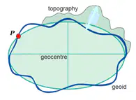
what is the value of geoid undulation in this case?
Zero
h-H
H-h
none of the above
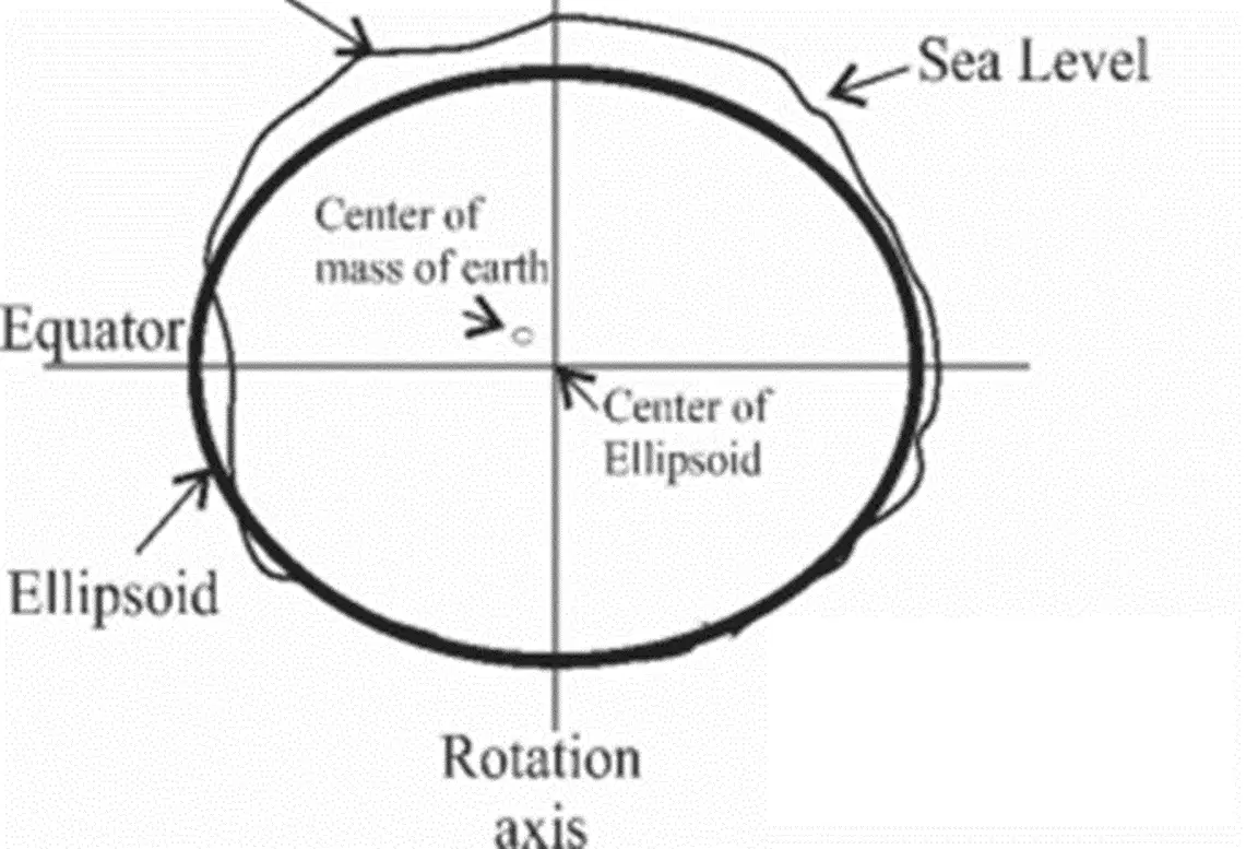
The shown ellipsoid is ......
Geocentric
Topocentric
WGS84
None of the above
ellipsoidal height is meaured along ......
the vertical direction
the normal to ellipsoid
radial line to ellipse center
None of the above
The radius of curvature in the prime vertical is always greater than its counterpart in the meridian direction.
True
False
Geodesy is .....
the science of determining the size and. figure of the earth, and its external gravity field
the science of studying geology of the earth
the science of determining the archeological excavations
None of the above
.......... geodesy studies and determine the gravity field of the earth.
Satellite
Remote sensing
Physical
Geometric
Eratosthenes’ experiment aims to determine ....
Rotational axis of the earth
Flatness of the earth
Earth's gravity field
radius of the earth
Geoid is an ....... surface
Equipotential
Mathematical
Ellipsoidal
None of the above
What is the primary reason for using the geoid in surveying and mapping?
To create visually appealing topographic maps
To ensure consistency in distance calculations over long distances
To establish a standard global coordinate system
To account for the Earth's irregularities and provide accurate height measurements
Which surface represents the "mean sea level"?
Topographic surface
Geoid
Ellipsoid
None of the above

This figure shows ......... latitude
Geocentric
reduced
Geodetic
None of the above
Direction of plumb line is not a straight line because .......
Variations in atmospheric pressure lead to the vertical direction being non-linear.
The Earth's magnetic field causes the direction of the vertical to deviate from a straight line.
Equipotential surfaces are not parallel
None of the above

